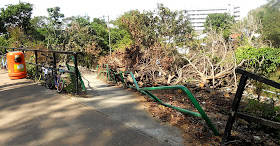
When Typhoon Mangkhut hit Hong Kong on 16th September, at least 55,000 trees were uprooted, and many more were damaged, having branches or tops ripped off. More than two months later, signs of the damage wrought by the most powerful tropical cyclone to tear through the territory since records began can still be seen everywhere.
I’ve been back in the territory for a week, and without travelling too far, I’ve been trying to record some of the more obvious signs of the disruption caused on that fateful day in September. Obviously, most of the uprooted trees have been cleared, especially where they blocked roads that in normal times would be busy, but some of the photographs below show trees that are likely to remain indefinitely where they fell.
As usual on my first day back in Hong Kong, Paula and I go for a short bike ride along the frontier road. And this was the first sign of damage:
It looks as though this tree fell across the road, but now that the blocking section has been sawn off and removed, I imagine that what remains will simply be left to rot—or regenerate.
The frontier road eventually joins Ha Wan Tsuen East Road, which in turn leads to the frontier fence. The following photo of Paula cycling on this road also shows some of the damage here:
Although ‘Lok Ma Chau’ is the name of an MTR station and a border crossing point, the actual village of that name lies at the end of a road that leads nowhere else, which is why I don’t expect any more effort to be expended in clearing the fallen tree next to this road:
A bike ride along the frontier road means having to come back the way you came, but we always turn off at the top of the climb out of the frontier area to the village of Liu Pok, where I took this photo:
No uprooted trees here, but if you look closely, several trees have had branches or tops snapped off by the wind (in case you were wondering, we come this way in order to do Liu Pok Hill).
There are only two places where it is possible to cross the railway between Sheung Shui station and the border, and this is a view, looking east, of the one that we always use:
There are no major uprootings here, but notice the piles of smaller arboreal debris on the pavement (sidewalk). There are similar piles of debris in many other places, and it looks as though it is awaiting collection. I believe that it is all destined for landfill!
The next fallen tree is located close to the site of the previous photo and has been sawn into lengths that will be easy to remove, eventually:
The next two photos show a section of the footpath between the village where I live and Fanling. The first photo was taken looking towards Fanling, while the second is a view of the same location from the opposite direction:
The next two photos show trees that have fallen into a storm drain close to the village of Tsung Yuen Ha, which is next to the border northeast of Fanling. The Drainage Services Department (DSD) access road on the left of each photo is a part of my regular Sunday bike ride.
Whenever we cycle west of Fanling, we need to follow a tree-lined road through a part of Sheung Shui, and Paula has often commented on how picturesque this road is. We reach it by cycling through a squatter area from the Ng Tung River, and we arrive at the road by coming up the ramp seen in this photo:
The tree that fell on the railing must have been a big one, but it has since been removed.
Here are two photos that give some indication of the extent of the damage to trees along this road:
I photographed the next fallen tree next to the Ma Wat River, which marks the southern boundary of Fanling:
…while the next photo was taken further along the cycle track that runs alongside the river and shows more debris awaiting collection:
Ma Sik Road marks the eastern boundary of Fanling. On one side there are only high-rise apartments, while the other side is completely rural. The footpath in the next photo runs parallel to this road, and only the central section of the trunk of the fallen tree has been removed—to allow passage along the path:
My guess is that the rest of the tree will remain where it lies indefinitely:
I’ve included the next photo, from a location close to the Ng Tung River, because it shows a tree that has snapped rather than been uprooted:
The next photo, which was taken close to the west bank of the Ng Tung River west of the main railway line, shows another tree that may remain where it is indefinitely because it isn’t causing an obstruction:
Remedial work is still taking place, as this photo of a location adjoining the main north–south cycle track through Fanling and Sheung Shui shows:
My final photo is of the remains of what would have been quite a large uprooted tree in an enclosed plot next to Sha Tau Kok Road, an extremely busy road leading east from Fanling:
It is probably just as well that the #10 signal, the highest in Hong Kong’s typhoon alert system, has been issued just fifteen times since the Second World War. If this kind of devastation were to become an annual occurrence, I shudder to think how Hong Kong would cope.


You may see how the government handled the fallen trees almost two months ago in https://www.scmp.com/news/hong-kong/health-environment/article/2166343/12-football-fields-former-kai-tak-runway-become
ReplyDeleteI’d already read the SCMP story, but to allow readers to avoid having to cut and paste the URL, this is the link.
Delete