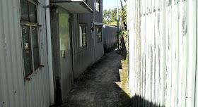
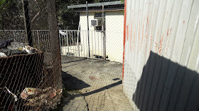
Although I’ve spent a lot of time during the past few years exploring the countryside around Fanling on my bike, I didn’t pay much attention to the area to the east until last winter. I had explored Lau Shui Heung Road, which joins Sha Tau Kok Road—the main road out of Fanling to the east—about 2km from the town, but I had no idea what lay within the angle between the two roads until I decided to take a closer look. The result was ‘fruity pie’, an intricate route through a maze of narrow alleyways that emerges, eventually, onto Lau Shui Heung Road (the name I gave to this segment is a corruption of the name of the village from which it starts—Fu Tei Pai).
There are two T-junctions on this route where the left-hand option merely returns you to where you started (they occur at 4.40 and 5.15 in the fruity pie video—fruity pie itself starts at 3.51, but the approach to this point provides a good idea of what I’ve described elsewhere as ‘rural sprawl’ looks like). And here is a still from the video that shows the second of these T-junctions:
Notice that if you turn right, there is a path to the left within a few metres, but because continuing straight on eventually leads to somewhere that I could link into a contiguous route, I never returned to investigate.
However, a couple of weeks ago, I was exploring the area on foot. I was on Sha Tau Kok Road, about to use a light-controlled pedestrian crossing to reach the north side, when I spotted a gap in the buildings to my right that I’d never noticed before despite cycling past it dozens of times. Regular readers will recognize my response immediately:
Where does this go?
I ventured down the usual quota of culs de sac, but I eventually came to somewhere that I recognized—the second of the T-junctions described above. And of course I spotted the left turn and decided to investigate more closely. This is what the path looks like from fruity pie:
Not very promising, you might think, but it does get better:
What you can see in the distance in the previous photo is a bricked-up gateway, and the left turn is forced:
This is a close-up of the junction visible in the previous photo. When first exploring this section, I came from the right and took the path that is straight on in this photo:
…so all I had to do was backtrack on my previous exploration and I would have a new cycling option to enjoy.
The following sequence records how I got back to Sha Tau Kok Road.
It isn’t obvious, but the route turns left immediately after the building on the left:
…then right:
The route turns left at the T-junction seen in the previous photo:
…although I suspect that it may be possible to continue straight on where I advocated turning left above and rejoining the route described at this point.
This is a close-up of the junction shown in the distance in the previous photo:
By this stage, I knew to turn right at this point, because turning left would merely lead to a dead end:
I would like, eventually, to work out a route where I cycle this in the opposite direction, because ramps like this are much more fun going up rather than down:
A footbridge over the river and a short up-ramp lead to Sha Tau Kok Road:
At this point, I have to confess that whichever way I might cycle this route in the future, I haven’t ridden it in either direction to date. I can’t point to an incident that has caused the problem, but I’ve somehow sustained an injury that makes it almost impossible to ride a bike. I must be getting too old for this game.
update: 18/01/19
I finally had a chance yesterday to see what this sequence of paths and alleyways is like on a bike. The right turns shown in photos #5 and #12 (above) are particularly tricky—I almost went off the path on the outside of the turn while trying to negotiate the first of these, which as you can see from photo #6 would have been fairly disastrous.


Hey there, You've done a fantastic job. I'll certainly digg it and personally recommend to my friends.
ReplyDeleteI am sure they'll be benefited from this web site.
Thank you for your support.
Delete