Although we had been out cycling on the previous two days, we still planned to go out for another ride on the third day. However, there was a slight problem: when I’d looked at the weather forecast the previous evening, there was a lightning symbol in the forecast for noon, which meant that we would have to go out early. Unfortunately, when I checked the forecast again the following morning, I noticed that a rain symbol had been added for 11am. It seemed prudent to eschew the cycling and go for a walk instead.
Because we live close to the northwestern edge of Penrith, when going for a walk we will always head north to begin with. This takes us through the Thacka Beck Nature Reserve, after which, on this occasion, we followed the eastern edge of town, which is also the highest, southwards until we reached the small hamlet of Carleton.
Sixty years ago, Carleton had been located at the junction of the A66, a major road connecting Penrith to Scotch Corner, a major junction on the A1, and the A686, which leads over the Pennines to Newcastle-upon-Tyne. However, the A66 was rerouted in the late 1960s as part of the infrastructure associated with the construction of the Penrith bypass, now part of the M6 motorway. It is no longer possible to follow the original route of the A66 south from Carleton in a motor vehicle, although it is still possible on foot.
Incidentally, ‘Carleton’ is of Old English (Anglo-Saxon) origin. The suffix –ton indicates a farm, while carle means ‘serf’ or ‘peasant’. Carleton was separated from Penrith sixty years ago by an extensive area of fields, but during the intervening years, residential development has meant that the two are now contiguous.
The River Eamont runs from west to east a short distance south of Carleton and can be reached by following the old route of the A66. While most of the rivers in Cumbria have names that are Cumbric in origin (Cumbric was the language spoken by the original inhabitants of the region but became extinct in the 11th century), ‘Eamont’ is purported to be of Old English origin. The first element, ea–, means ‘water’, while the meaning of the second element should be obvious. The most likely meaning of these juxtaposed elements is ‘water from the mountains’.
This is not a fanciful interpretation. The source of the Eamont is Ullswater, the second-largest of the lakes in the district. Ullswater is a narrow ribbon lake about nine miles long that is surrounded by mountains, which provide a considerable catchment area during periods of heavy rain. All this runs off into the lake and thence into the Eamont.
The straight-line distance between the outflow from Ullswater and the Eamont’s confluence with the River Eden is no more than about 12 miles, but the actual length of the river is more than twice this because it meanders all over the place. Unsurprisingly, therefore, the Eamont is prone to catastrophic flooding following winter storms, which dump considerable amounts of rain on the mountains. In one such storm a few years ago, the bridge at Pooley Bridge, the first to be encountered from the river’s source, was swept away, and houses close to the river are often overwhelmed by floodwater.
Our objective on this occasion was the footpath along the north bank of the Eamont from Brougham upstream to Eamont Bridge, which has always been the most important crossing point over the river. Here are a few photographs that I took along the way:
It was quite a warm day, and most of the sheep in the first field were sheltering from the sun in the shade of a large tree:
This is a general view of the river, looking upstream:
I hadn’t expected to see a grey heron here.
Lone trees in the middle of fields are a common sight. I sometimes wonder whether they have been left by the farmer simply to provide shelter for his livestock:
I simply had to include the following photos of a spectacular bracket fungus growing on a sycamore:
One of Paula’s colleagues is a mycologist, so I might be able to find out the species.
I hadn’t been along this path for several years, but I felt sure that at one point close to Eamont Bridge there had been a footbridge across the river. If I’m correct, then that footbridge has also fallen victim to the rapacity of the river:
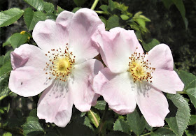
To end on a lighter note, here is a photo of a wild rose that I took just before reaching Eamont Bridge:


It was CERTAINLY another INTERESTING walk to discover the fungus that spreads wide like a broad brim hat, walk in a trail with plenty of sheep's excrement while not encountering a drop of rain.
ReplyDeleteI thought you would remember this walk. It was certainly interesting!
Delete