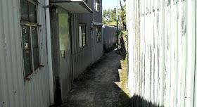
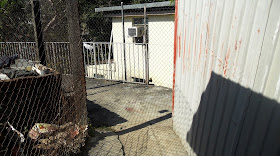
The final frontier, which is probably my favourite bike ride, is feasible only on Sundays and public holidays because of the amount of industrial traffic on key road sections. However, due to a combination of injury and illness, I hadn’t done it for more than two months—until yesterday.
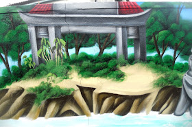
It isn’t a difficult segment of the ride, but the path that I originally described in Ghost Alley is an integral part of the day’s adventure. The attraction here is the artwork—on footpaths, on walls, on houses—although nothing new had appeared during the past two years. Nevertheless, every time that I pass through the area, I’m on the lookout for new developments, although even if I hadn’t been paying attention yesterday, I couldn’t have missed a sensational new mural on the wall opposite the ‘ghosts’.
Because the alleyway is quite narrow, it’s impossible to photograph it all in one go, but here is a sequence of four photos that I hope convey something of the artistry involved:
The photos are arranged in the sequence that you would see if approaching from Ping Yuen Road, which is the usual direction that a visitor would come from. The colours have not been enhanced, and the painstaking workmanship is obvious. I wonder if this is someone’s vision of an earthly paradise, or an ironic observation that such a paradise would be empty.
The usual exit from the ghost alley area is via what Paula once christened ‘the giraffe path’. This collection of painted stones is an interesting way to introduce more colour into the scene, although I cannot guess the thinking behind their use:
The paintings on the house behind are not new.
A lot of the original footpath art around here has faded, but the artwork on the two elaborately decorated houses is reasonably well preserved, and the ‘ghosts’ are as ethereal as ever. This new mural is a splendid addition to a location that is marked on Google Maps as ‘Ping Yeung Mural Village’. It is well worth a special visit.
see also
Ghost Alley Revisited
More From Ghost Alley
Monday, 28 January 2019
Wednesday, 16 January 2019
the house on the hill
I like to boast to myself that I know where every lane, track, path and alleyway in my neighbourhood leads to, so I was surprised last week to discover that I was wrong. There is a road leading off the misleadingly named Lok Tung Street next to the abandoned and now ruined mansion of Shek Lo, which is mentioned as a point of interest on the Lung Yeuk Tau Heritage Trail, although it isn’t possible to gain access:
This photo was taken five years ago, when access was still possible.
The side road leads eventually to a Christian cemetery, although I’d forgotten this fact when I went there last week because I suspected that there might be a path hereabouts that leads over the mountain and thence to Taipo. There isn’t.
However, as I walked back down the road, I noticed the kind of track that does look as though it should lead somewhere:
So far, so good:
It wasn’t long before I reached somewhere familiar. I’d been here before:
The gate is locked, but it’s possible to see that it leads to an elaborate grave, clearly the final resting place of someone important. The structure behind the gate is a shelter where relatives of the occupant who come here to tidy the grave during the Ching Ming festival can rest.
There is also a broad concrete path heading up the hillside to the right of the camera position. As I suspected, it leads to another grave:
According to the inscription, this is a grave of the Chiu family:
The guarding animal—there is another on the right-hand side—may be a lion, but to be honest it looks more like a dog.
This photo shows just how elaborate the grave is:
When I returned to the road, I almost didn’t continue over the hill, because I thought I remembered that the road quickly reached a dead end . However, I thought, I’d better make sure:
The yellow car marks the furthest that it’s possible to drive. There are several substantial squatter houses around here:
Just after I reached this point, I noticed an old lady ahead, so I decided to stop to take a couple of photographs to give her time to get to wherever she was going:
The high-rise blocks in the first photo define the eastern edge of Fanling (the yellow-tiled structure in the foreground is a small ossuary). The second photo is a view through the next gap in the trees, at an angle about 60 degrees clockwise from the first, of a cluster of very substantial squatter houses.
The old lady was still ahead, but the path is wide, so I could overtake without causing her any inconvenience. And it clearly goes a long way:
This was the most obvious legacy contribution of Typhoon Mangkhut that I found hereabouts:
I can’t imagine this tree ever being removed, or the railing repaired!
A short distance further on, I came to a cluster of at least a dozen substantial squatter houses over a distance of about 50 metres:
Judging by the canine cacophony that I encountered here, they are all still occupied.
The red signs in the third and fifth photos carry the following information:
The path continues beyond this cluster of houses, but it doesn’t appear to be cleared too often, and nature is gradually encroaching on the sides:
Up to this point, I’d been optimistic that I’d discovered the path that I’d conjectured led over the mountain. I could now see that I didn’t have much more height to gain before I reached the col. I was beginning to dream of a major cycling option—remember, I was on foot—but I was about to hit a snag:
Three steps doesn’t constitute a barrier, and it might even be fun to see if I can ride up them. The sharp turn to the right is likely to be tricky though. The ramshackle dwelling behind the steps has been abandoned.
However, even if I could get past this obstacle, the next would be impossible on a bike:
…although I could always get off and push:
Unfortunately, the next section appears to be impassable, even on foot:
However, when I reached this point, I did think that I could make out some kind of built structure through the foliage, and by getting down on my hands and knees, I was able to reach it. This is a view from the opposite side of the building to the approach:
I was struck immediately by the quality of construction: neatly pointed stone blocks in parallel courses. Why would anyone go to the considerable trouble of hauling the stone all the way up here?
The door was wide open. It was very dark inside, but I was able to take two photos using flash:
Somebody lived here once, but it has clearly been abandoned for a while—the calendar on the wall is open at February 2002. I wonder if it has been ransacked since the original occupant left, given that the drawers in the chest of drawers have been pulled out and up-ended. But who would come this way? There is no continuation of the path beyond this building.
Given the quality of construction, not only of the ‘house’ but also of the approach path, and the fact that the path goes no further, I wonder if the building originally served some other, possibly official, purpose. But what? I cannot resolve this conundrum. Can you help?
This photo was taken five years ago, when access was still possible.
The side road leads eventually to a Christian cemetery, although I’d forgotten this fact when I went there last week because I suspected that there might be a path hereabouts that leads over the mountain and thence to Taipo. There isn’t.
However, as I walked back down the road, I noticed the kind of track that does look as though it should lead somewhere:
So far, so good:
It wasn’t long before I reached somewhere familiar. I’d been here before:
The gate is locked, but it’s possible to see that it leads to an elaborate grave, clearly the final resting place of someone important. The structure behind the gate is a shelter where relatives of the occupant who come here to tidy the grave during the Ching Ming festival can rest.
There is also a broad concrete path heading up the hillside to the right of the camera position. As I suspected, it leads to another grave:
According to the inscription, this is a grave of the Chiu family:
The guarding animal—there is another on the right-hand side—may be a lion, but to be honest it looks more like a dog.
This photo shows just how elaborate the grave is:
When I returned to the road, I almost didn’t continue over the hill, because I thought I remembered that the road quickly reached a dead end . However, I thought, I’d better make sure:
The yellow car marks the furthest that it’s possible to drive. There are several substantial squatter houses around here:
Just after I reached this point, I noticed an old lady ahead, so I decided to stop to take a couple of photographs to give her time to get to wherever she was going:
The high-rise blocks in the first photo define the eastern edge of Fanling (the yellow-tiled structure in the foreground is a small ossuary). The second photo is a view through the next gap in the trees, at an angle about 60 degrees clockwise from the first, of a cluster of very substantial squatter houses.
The old lady was still ahead, but the path is wide, so I could overtake without causing her any inconvenience. And it clearly goes a long way:
This was the most obvious legacy contribution of Typhoon Mangkhut that I found hereabouts:
I can’t imagine this tree ever being removed, or the railing repaired!
A short distance further on, I came to a cluster of at least a dozen substantial squatter houses over a distance of about 50 metres:
Judging by the canine cacophony that I encountered here, they are all still occupied.
The red signs in the third and fifth photos carry the following information:
The areas in the vicinity of this sign are subject to landslip risk. Some squatter huts have been recommended for clearance. Locations of the affected squatter huts are available from the Geotechnical Engineering Office at 2760 5715. Please stay away from the areas during Landslip-Warning Signal, Typhoon Signal No. 8, or heavy rains.I wouldn’t describe any of these dwellings as ‘huts’, and the possibility that they could be swept away in a landslide here has, in my opinion, been exaggerated. However, Hong Kong does have a history of landslides that could fairly be called disasters, which is why the Geotechnical Services Department was created in the first place.
The path continues beyond this cluster of houses, but it doesn’t appear to be cleared too often, and nature is gradually encroaching on the sides:
Up to this point, I’d been optimistic that I’d discovered the path that I’d conjectured led over the mountain. I could now see that I didn’t have much more height to gain before I reached the col. I was beginning to dream of a major cycling option—remember, I was on foot—but I was about to hit a snag:
Three steps doesn’t constitute a barrier, and it might even be fun to see if I can ride up them. The sharp turn to the right is likely to be tricky though. The ramshackle dwelling behind the steps has been abandoned.
However, even if I could get past this obstacle, the next would be impossible on a bike:
…although I could always get off and push:
Unfortunately, the next section appears to be impassable, even on foot:
However, when I reached this point, I did think that I could make out some kind of built structure through the foliage, and by getting down on my hands and knees, I was able to reach it. This is a view from the opposite side of the building to the approach:
I was struck immediately by the quality of construction: neatly pointed stone blocks in parallel courses. Why would anyone go to the considerable trouble of hauling the stone all the way up here?
The door was wide open. It was very dark inside, but I was able to take two photos using flash:
Somebody lived here once, but it has clearly been abandoned for a while—the calendar on the wall is open at February 2002. I wonder if it has been ransacked since the original occupant left, given that the drawers in the chest of drawers have been pulled out and up-ended. But who would come this way? There is no continuation of the path beyond this building.
Given the quality of construction, not only of the ‘house’ but also of the approach path, and the fact that the path goes no further, I wonder if the building originally served some other, possibly official, purpose. But what? I cannot resolve this conundrum. Can you help?
Sunday, 13 January 2019
brick-a-brac
The villages immediately east and southeast of Fanling are characterized by what I’ve often described as ‘rural sprawl’. Most modern village houses—those built since the mid-1970s according to a legal formula that defines maximum height and floor area—have been sited in an indiscriminate, higgledy-piggledy fashion that makes it impossible to locate where one village ends and another begins, unless, of course, you live in one and are therefore aware of your address.
However, there are some pockets of regularity, where the houses have been laid out in a rectilinear grid with narrow alleyways between individual buildings. This is the case with Tsz Tong Tsuen, or at least that part of the village immediately east of the Tang Chung Ling Ancestral Hall, the largest ancestral hall in Hong Kong. Tsz Tong Tsuen is one of six tsuens (villages) and five wais (walled enclosures) established in this area by the Tang clan during the Ming Dynasty (1368–1644). The six villages lacked defensive walls, so it would have been natural to group the houses close together to make them easier to defend against marauding pirates and other ne’er-do-wells. Pirates were a constant menace in southern China for centuries.
In the case of Tsz Tong Tsuen, the present grid is made up almost exclusively of modern houses, but I conjecture that they were all built on the sites of older houses, which from my observations elsewhere are first abandoned, then are allowed to decay and finally are demolished and replaced.
I don’t usually walk through such places, but for some reason I decided to take a short cut last week via an east–west alleyway in Tsz Tong Tsuen. My attention was drawn immediately to the distinctive roof tree of a traditional Chinese house down an alleyway to my right (north):
Incidentally, I haven’t confirmed that these alleyways run precisely north–south and east–west, but the orienting of houses has always been important in Chinese culture (fung shui), and the layout is certainly close to what I’ve suggested.
Whatever lies behind the foliage on the left is of absolutely no interest, or so I thought, although a glance down the next alleyway to the left did appear to confirm that initial conclusion:
But I was wrong:
Although I may make erroneous assumptions, I will still look for confirmation. You may need to take a closer look at the brickwork on the left to see what I’m getting at:
The brickwork at the base of the wall is fairly conventional, but I have never seen bricks in a wall arranged in such a chaotic diagonal jumble.
But there’s more:
Of course, the brickwork on the corner of this building is fairly conventional, but there are two other things to note: the range of brick colours; and the variations in brick size. The first points to a range of different sources for the clay, while the second suggests that each brick was hand-moulded before being fired.
And if you want to see what the range of colours does to the ‘chaotic diagonal jumble’, look no further:
A point to make about the previous image is that although there is mortar between the bricks in the horizontal brickwork on the left, the main wall appears to have been built without, apart from occasional dollops here and there that I suspect are not original. In fact, if you look closely, small stones have been used to fill in some of the larger gaps!
This is what this wall looks like from the southwest corner. Note that the top of the wall is conventional brickwork, and the corner has been rendered:
This is a view down the south side of the building, looking east:
…while this is the view from the opposite direction:
There appears to be an inner wall supporting the chaotic outer wall, and the only way in is also visible, although I cannot believe that the building is still occupied. Would you allow such a creeper to obscure this much of your front door?
Incidentally, the traditional house that originally attracted my attention is derelict. I had hoped that there would be some painted friezes and polychrome mouldings to record. There would have been once, but they’re long gone.
Saturday, 5 January 2019
fruity pie: second helpings
Although I’ve spent a lot of time during the past few years exploring the countryside around Fanling on my bike, I didn’t pay much attention to the area to the east until last winter. I had explored Lau Shui Heung Road, which joins Sha Tau Kok Road—the main road out of Fanling to the east—about 2km from the town, but I had no idea what lay within the angle between the two roads until I decided to take a closer look. The result was ‘fruity pie’, an intricate route through a maze of narrow alleyways that emerges, eventually, onto Lau Shui Heung Road (the name I gave to this segment is a corruption of the name of the village from which it starts—Fu Tei Pai).
There are two T-junctions on this route where the left-hand option merely returns you to where you started (they occur at 4.40 and 5.15 in the fruity pie video—fruity pie itself starts at 3.51, but the approach to this point provides a good idea of what I’ve described elsewhere as ‘rural sprawl’ looks like). And here is a still from the video that shows the second of these T-junctions:
Notice that if you turn right, there is a path to the left within a few metres, but because continuing straight on eventually leads to somewhere that I could link into a contiguous route, I never returned to investigate.
However, a couple of weeks ago, I was exploring the area on foot. I was on Sha Tau Kok Road, about to use a light-controlled pedestrian crossing to reach the north side, when I spotted a gap in the buildings to my right that I’d never noticed before despite cycling past it dozens of times. Regular readers will recognize my response immediately:
Where does this go?
I ventured down the usual quota of culs de sac, but I eventually came to somewhere that I recognized—the second of the T-junctions described above. And of course I spotted the left turn and decided to investigate more closely. This is what the path looks like from fruity pie:
Not very promising, you might think, but it does get better:
What you can see in the distance in the previous photo is a bricked-up gateway, and the left turn is forced:
This is a close-up of the junction visible in the previous photo. When first exploring this section, I came from the right and took the path that is straight on in this photo:
…so all I had to do was backtrack on my previous exploration and I would have a new cycling option to enjoy.
The following sequence records how I got back to Sha Tau Kok Road.
It isn’t obvious, but the route turns left immediately after the building on the left:
…then right:
The route turns left at the T-junction seen in the previous photo:
…although I suspect that it may be possible to continue straight on where I advocated turning left above and rejoining the route described at this point.
This is a close-up of the junction shown in the distance in the previous photo:
By this stage, I knew to turn right at this point, because turning left would merely lead to a dead end:
I would like, eventually, to work out a route where I cycle this in the opposite direction, because ramps like this are much more fun going up rather than down:
A footbridge over the river and a short up-ramp lead to Sha Tau Kok Road:
At this point, I have to confess that whichever way I might cycle this route in the future, I haven’t ridden it in either direction to date. I can’t point to an incident that has caused the problem, but I’ve somehow sustained an injury that makes it almost impossible to ride a bike. I must be getting too old for this game.
update: 18/01/19
I finally had a chance yesterday to see what this sequence of paths and alleyways is like on a bike. The right turns shown in photos #5 and #12 (above) are particularly tricky—I almost went off the path on the outside of the turn while trying to negotiate the first of these, which as you can see from photo #6 would have been fairly disastrous.


