Showing posts with label video. Show all posts

Monday, 25 November 2024

peak viewing

“Let’s go up the Peak,” suggested Paula recently.

Victoria Peak, the highest summit on Hong Kong Island, is the only major mountain in Hong Kong that I don’t know the Chinese name of. However, it’s always been simply ‘the Peak’, hence the wording of Paula’s suggestion. How to get there is the first problem. We can get a train from Fanling to Admiralty station on the island side (this line used to terminate at Hung Hom, on Kowloon side, but was extended by the MTR a few years ago), followed by a short walk to Central. From here, if you’re a tourist, you will probably take the Peak Tram (actually a funicular railway), but we always take the bus, mainly because the views are far superior—on the tram, you’re tilted backwards at an obscene angle, so you can’t see much, although if you’ve never tried it, then you should. Just once though.

The bus terminates next to the upper terminus of the tram, so there’s no effect on what you might want to do next. It is possible to continue uphill on foot, although the actual summit of the Peak is inaccessible because it houses a radio station. We always start by walking along Harlech Road, which contours the southern side of the Peak. There are occasional views to the south, but nothing particularly impressive. And despite the crowds around the tram terminus, it’s relatively quiet on this road, with few people and almost no traffic:
I never notice at what point we find ourselves on Lugard Road, which crosses the northern slopes of the Peak with no major gradients, ending eventually at our starting point. However, according to the government map Harlech Road continues straight on where Lugard Road branches off to the right somewhere around the col that separates the Peak from nondescript higher ground to the west. The last time we visited the Peak, we encountered a couple of young wild pigs around the col, and I shot quite an intimate video:

The individual that accounted for the bulk of the time in this video was probably expecting to be fed. Incidentally, I hadn’t realized that there are wild pigs on the island side, although I’ve seen many of these creatures in the New Territories.

I’d carelessly neglected to charge my phone before this excursion, and we spent some time in Hong Kong Park, where I took more than 60 photos, before catching the bus to the Peak, so I shouldn’t have been surprised when my phone decided to switch itself off to conserve power as we walked along Harlech Road. Consequently, I asked Paula to take some photos whenever a gap appeared through the trees as we walked along Lugard Road. What follows is a selection of her photos, with occasional explanatory comments from me.

The first two photos are views of what might be called the ‘western approaches’ to the harbour:
Almost all the high-rise blocks that you can see in the foreground of these photos are residential buildings. The buildings in the distance in the second photo are part of the town of Tsuen Wan, the northern terminus of the MTR’s Tsuen Wan Line to Central, one of the first lines to be constructed in what is now a very extensive network.

And this was our first view of the harbour, with a glimpse of the building that dominates the view towards Kowloon:
I don’t know the name of the building, which is located on land reclaimed from the sea since the handover to Chinese rule in 1997. The entire reclaimed area is known collectively as ‘West Kowloon’.

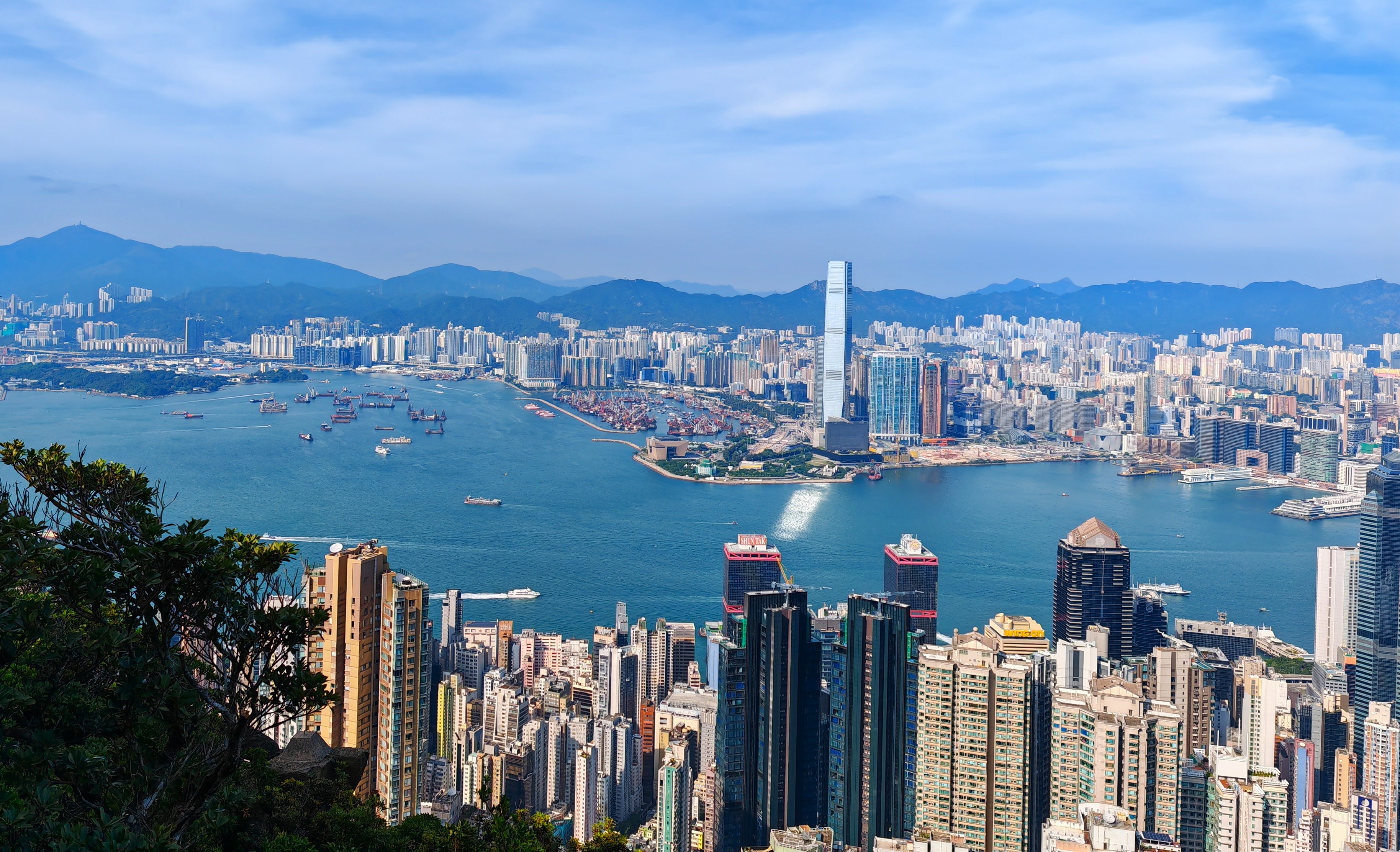
The next photo provides a fairly comprehensive view of Kowloon:
You will notice that there aren’t many super-high buildings. The reason for this situation is that when Hong Kong’s airport was located at Kai Tak, in eastern Kowloon, a height restriction (18 storeys) was in force. Notice too the line of mountains in the distance. ‘Kowloon’ means ‘Nine Dragons’ in Chinese, referring to these mountains. I can’t positively identify any of these summits apart from the one on the far right, which is Fei Ngo Shan (‘Flying Goose Mountain’), better known simply as ‘Kowloon Peak’.

The next two photos are essentially the same view from different angles:
Notice that there are now quite a few commercial buildings in the foreground. This is because the area below is the central business district, better known simply as ‘Central’.

These are views looking east along the harbour (shots taken from different locations):
The final four photos are general views from different positions, which I present without further commentary:
One final comment: it would seem from many observations over the years that a majority of people who follow this walk do so in the opposite direction. This might seem like the logical direction to follow—spectacular views almost straight away—but if you follow Lugard Road first, Harlech Road is going to seem like an anticlimax. We will always circumnavigate the Peak in a clockwise direction!

Sunday, 31 December 2023

extraordinary egret exhibition

I often see egrets in our local river (Ng Tung River), but they are almost always solitary individuals, with just the odd occasion when I see two or three. This is in sharp contrast to the situation on the Kam Tin River (out west), where I frequently see large groups of egrets, together with cormorants, black-winged stilts and even the occasional spoonbill. However, this can be explained by the section of the Kam Tin River that we cycle along being a typical estuarine environment, with large areas of mangroves along the shore, while the Ng Tung River is about as far from the sea as it’s possible to get in Hong Kong.

I do see the occasional grey heron here, but nothing could have prepared me for the recent sight of dozens of egrets lined up alongside the winter channel of the river (all the rivers hereabouts have been canalized to prevent flooding, which I surmise would once have been a regular occurrence). And it wasn’t a one-off sight either. Each day for a week, it was party time for egrets on the section of the river that is visible from the road bridge linking the villages of San Wai (where I live) and Siu Hang.

18th december
On this date, Paula and I had walked up the river—something we rarely do nowadays because of the construction in progress—and when we reached the bridge we couldn’t fail to notice all the egrets in the river:
You can see a small part of the ongoing construction in both photos, and also the confluence with the Ma Wat River, which joins the Ng Tung River from the left in the middle distance.

19th december
The following day, when crossing the river, I couldn’t help but notice the concentration of egrets upstream from the bridge:
There are thousands of tiny fish in the winter channel—hence the lines of egrets on each side—which you can see from the bridge on sunny days because the light catches them as they move through the water.

Incidentally, the mountain in the distance is Hung Fah Leng (‘Red Flower Ridge’), otherwise known as Robin’s Nest, although I avoid using silly gweilo toponyms.

20th december
It was sunny on this day, although the fish are too small to be captured by my camera:
This is a closer view of the crowd of egrets where the river bends to the right:
21st december
The crowds were definitely largest on this day:
The first three photos were taken from different positions along the bridge on my way downriver, and the other three were taken about 20 minutes later, on my way home. I couldn’t decide which photo(s) to leave out, so I’ve included them all!

22nd december
This was undoubtedly the quietest day in the seven-day period:
23rd december
This occasion was the only one where I saw egrets close to the bridge on the downstream side:
The mountain in the distance is Lung Shan (‘Dragon Mountain’).

This is a view from the bridge of the same scene, looking directly down to the water:
24th december
Although I walk across the bridge every day, this was the last day when I saw more than two or three egrets. Perhaps they’d exhausted the fish supplies.
*  *  *
Regular readers of this blog will be aware that I’ve posted no new material for the past two months. It’s my ongoing problems with a lower back injury sustained back in July, which means that I cannot sit for extended periods. However, I wanted to post something before the end of what has been a fairly dismal year, and my recent encounters with egrets in our local river seemed a fitting subject.

On the bright side, since last month, I’ve been able to walk extended periods without the aid of a stick, and Paula and I have been out cycling twice a week this month, which has included two 62km rides, although I do have to be careful when stopping and putting my foot down. Here are two videos (shot on an earlier occasion) of part of the ride we did just two days ago:


I found the spiral ramp, which occurs between 5.06 and 5.21 in the first video, to be a bit of a beast! The hidden ramp starting at 2.22 in the second video is also quite tricky, especially if you don’t know it’s there.

I expect to resume posting regularly next month. I have two more reports to write that pertain to our trip to Switzerland in September, and there was a major event centred on the local ancestral hall (held, I believe, every ten years) earlier this month attended by many hundreds of people. I took a lot of photos, and here’s a taster:
I think that you will find a full account fascinating.

Wednesday, 5 July 2023

an incredibull encownter

In my last post, I described how Paula and I failed to find the continuation of the public footpath to Catterlen after we’d crossed the River Petteril, and as a result we followed an alternative path that led to a few problems with cows as we crossed their field. Well, a few days later we were back to make another attempt to follow the missed path, and this time we succeeded, albeit not without more problems with cows.

I took a few photos of the first section of the ‘path’, which to start with can be more accurately described as a ‘track’:
Although the track starts off by running parallel to the motorway, this first photo shows the point where it starts to diverge away.

More photos:
After we passed the open gate that I described in my previous post, the way becomes considerably overgrown:
…but we eventually reach a gate on the left, from where the path crosses an open field towards the first footbridge over the River Petteril:
The way ahead, up the hill on the far side of the river, isn’t at all obvious. Before tackling the hill, I took this photo of masonry ruins:
I can only guess its original purpose, although I suspect that it had something to do with drainage in the area.

From a point further up the hill, I took this photo looking back down towards the river:
You can see the second footbridge, which we crossed during our earlier venture into this area, to the right of centre.

And then things started to get really interesting!
Thou shalt not pass! That was my impression, but I was having none of it:
I cleared a comfortable path across the field, but when we reached the gate into the next field, which was empty, we could see another herd massing behind the next gate. They were waiting for us when we reached the gate:
However, this was definitely the way to go, and I was able to induce these cantankerous cattle to get out of our way quite easily:
We reached Catterlen without further problems. Although the original signpost we had followed merely indicated the name of the village, the signpost in Catterlen specifically identified the path as a ‘bridleway to Penrith’, which means that there is a legal right to ride a horse along the route we’d just followed. I don’t think anyone does this nowadays though. In fact, I don’t think this path is followed by many walkers either.

Having reached Catterlen, there is no obvious off-road alternative to the way we’ve just come, so we simply followed the road, which carries very little traffic, to Newton Reigny, where we made an interesting discovery. I’ve cycled along this road in the opposite direction many, many times, but I never knew that this is Catterlen Hall (even though it’s in Newton Reigny):
The name is inscribed on the millstone partially embedded in the ground to the right of the bridge, but you can see how you would never notice it if you’re riding a bike:
At the bottom of this hill, the road crosses the River Petteril before joining a busier road that leads eventually to Penrith:
A separate footbridge strikes me as unnecessary!

This is the view downstream:
There is a direction/distance signpost at the junction I mentioned above:
I’ve included what seems like a trivial photo because of the lettering on the post: ‘Cumberland County Council’. Cumberland ceased to exist following local government reorganization in the 1970s, when Cumberland and Westmorland, together with the Furness District of Lancashire and a small part of the Yorkshire Dales, became a new county: Cumbria. This has now been abolished, and Penrith, which was in Cumberland fifty years ago, is now in Westmorland. What!?

Although the road from Newton Reigny to Penrith is unclassified, it does carry quite a lot of traffic. That is not a problem for cycling, but I didn’t fancy walking along it. However, I noticed a parallel track on the map to the southwest, which seemed like a much safer option. However, the middle section turned out to be heavily overgrown, which caused a few problems. This photo shows where the overgrown section reaches a good track, which we followed through Sewborwens Farm:
…and thus to Penrith
…without further problems.