For the past couple of weeks, I’ve been out and about looking for new examples of my favourite floral display of the year: the firecracker vine. I’ve also been visiting some of the locations I already knew about in the hope that I might be able to take some better photos than the ones I already had.
Consequently, I decided to visit the location of what I consider to be the finest single example of a firecracker vine in bloom that I already knew about (check out the first photo in
Jeepers Creepers #2 to see what I mean) one day last week. This location is about 6km downstream from our village, just before the Ng Tung River flows under the main railway line into China (when the border is open), so I planned to take in a few detours as part of what was clearly going to be a long walk.
Having left behind the construction area that currently blights the upper section of the river, I decided to cut away from the river to walk through the village of Wa Shan in the hope of spotting some new examples of firecracker vines. There were none here, but I did spot one in the distance, in what is clearly a forested area:
The pink in the foreground of the first photo is provided by
bougainvillea.
I wondered whether I could get a closer shot, because this vine was likely to be near ‘
the top road’. I could, although there was too much vegetation for an ideal photo:
Although firecracker vines are usually to be seen adorning the perimeter fences or walls of people’s gardens, this one was clearly a wild example. Unusual, but not unique, in my experience. I wondered whether it was an escapee from someone’s garden, or whether this was its natural state.
I returned to the Drainage Services Department (DSD) access road I had been following and continued downstream. Having crossed Man Kam To Road, a major highway into China (when the border is open), I decided to have a rest at the next covered seating area, kindly provided by the Home Affairs Department despite DSD ‘keep out’ notices. When I continued, almost immediately my ears pricked up. That sounds like goats, I said to myself, so I walked over to the side of the road to see whether I was right. I was:
I also shot a video:
My first thought was “how did they manage to cross Man Kam To Road safely?” Then I realized. This was a different herd to the one we often see upstream from this highway, almost all black, with just one white individual—the other herd includes several white and brown individuals. I followed the herd as it browsed slowly along, until it reached the area in the fourth photo, which apparently had enough to eat for them to pause for a while. I continued on my way.
Opposite the first footbridge across the river downstream from Man Kam To Road, there is a path that leads through a large cluster of small houses, eventually emerging onto Fu Tei Au Road. I’ve often cycled through here, because it provides quite a stern test of one’s bike-handling skills. However, this was the first time I’d been here on foot, and therefore the first time I noticed this memorial stone:
Although it’s difficult to read after more than half a century, it commemorates a catastrophic flood in 1964, before the river was canalized, and the subsequent rebuilding efforts, which included this rather quaint brick-arch bridge over the connection between two large ponds that are currently covered in dead water hyacinths:
This path leads eventually, through quite a few twists and turns, to the firecracker vine that was the original motivation for this expedition:
The target vine is on the left; there was no vine on the right when I took the photo that I included in
Jeepers Creepers #2.
This is a view looking down the path from Fu Tei Au Road:
The floral density of the vine on the roof is almost solid, but there were many more flowers above and right of the gate when I took the earlier photo. The building in the right middle distance is the Sheung Shui abattoir, the final destination for thousands of pigs from China every day.
Having taken several more photos here, which will be published later this week as part of this year’s survey of firecracker vines, I continued along Fu Tei Au Road to where it is joined by the DSD access road. My intention had been to cross a footbridge here and follow a footpath that runs alongside the slaughterhouse, but as a result of construction work here, unrelated to the construction in our neighbourhood, the path was blocked, so I had to backtrack along the DSD road instead.
This turned out to be a serendipitous move. After a short distance, I knew that I could join a path that runs parallel to the DSD road, and almost immediately that I did so, something in the distance caught my attention. From that distance, it appeared like printed material, because the colours were so bright, but it turned out, unexpectedly, to be a fascinating mural painted onto a brick wall:
It’s well worth taking a closer look:
I hadn’t realized at the time I took the photos that this is one contiguous scene, although I did notice that it was painted across a buttress in the wall, and the next buttress along was unpainted, thus separating this scene from a completely different scene further to the right.
You might think that the calendar on the wall is displaying a completely arbitrary date, but thanks to the plethora of homophones in the Chinese language, ‘two three’ sounds like ‘easy to accumulate riches’. The character on the calendar means ‘blessings’ and is seen everywhere around the time of the new year. This is clearly a new year scene, given the four-character invocations pasted on each side of the window. The one on the left means ‘one group happy’ (implying no arguments), while the one on the right means ‘plenty of money’.
Other things to note in this scene: the boy on the right is busy doing his homework, but the boy stealing around the buttress in the foreground, who should probably be doing his homework too, is more keen to join the two smaller children playing marbles. Note too the old-fashioned cathode ray tube television, and the collection of (presumably empty) wine bottles on the top shelf.
The right-hand painting is even more intriguing:
This photo was taken two days after my initial visit, partly because I’d inadvertently chopped quite a lot off the right-hand side of the image because I couldn’t get far enough away, given the width of the alleyway here, but mainly because I wanted Paula to see the mural (we waited two days because we’d planned to go out cycling on the intervening day, and given the dubious weather recently, that was a date that couldn’t be changed).
Paula was particularly amused by her observation that while the humans in this image are working hard (threshing rice, polishing rice, harvesting vegetables, fishing), the cat and the cow are taking it easy:
Incidentally, I haven’t seen rice being grown in Hong Kong since the 1970s, although I do recognize the threshing box being used to separate the rice grains from the rest of the plant.
It was only when I looked at the photo after we got home that it occurred to me that although it looks like a domestic pussy cat, the animal on the left is actually a tiger (and it’s slurping an ice cream cone), and cows are oxen (this cow is sipping a milk shake). And we are about to exit the Year of the Ox at midnight tonight, to be followed by the Year of the Tiger. So this part of the mural also has a new year significance, and I think that it must have been painted very recently, given the freshness of the colours.
By the way, I can’t explain the fish swimming in a pink sky, so if anyone can, please leave a comment.
Another thing I didn’t notice on my initial visit, but Paula did:
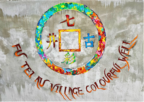
Easy to miss if you’re walking towards the camera: the sign reads ‘seven colours [rainbow?] ancient well’. The arrow points up a narrow alley, and of course we had to see where it led. It turned out to be a proverbial ‘blind alley’, but I noticed this painted plaque on one sidewall, just before the end:
The characters are the same as on the arrow, reading top, bottom, right, left. And the well is located in the left-hand corner at the end of the alley, surrounded on the two open sides by stainless steel railings:
Clearly, this well is no longer used as a source of water, but I wonder why it was considered ‘colourful’. I can only conjecture that evaporation of water from the well, combined with refraction of light through water vapour, somehow created a rainbow effect. I also wonder why its existence is both signposted and commemorated by a plaque, especially as very few people pass this way, even on the DSD access road. And I didn’t realize that Fu Tei Au is a village—there are no modern three-storey village houses here, or a public toilet—although perhaps I should have guessed, given that named roads in the New Territories tend to lead to wherever the road is named after.
I wasn’t about to return home the same way, so I crossed the river via the footbridge opposite the memorial stone, which leads to the road into the abattoir. I wasn’t paying attention, but when I came this way with Paula, she quickly spotted a truckload of pigs on their final journey. After that, I counted four more trucks carrying doomed pigs in the five minutes it took us to reach Po Wan Road.
I may not have been paying attention to traffic on the road, but I couldn’t help but notice this on the opposite side of the road:
The question is almost too obvious to ask: how do you polish effluent? The logo on the right is that of the DSD. And there is another question. The boundary here appears to be a hedge, but notice that the letters are quite wobbly. How were they fixed to the hedge, which doesn’t appear to have obscured a single letter?
The rectangle on the left appears to be a site map superimposed on an aerial photograph:
I think that there may be other intriguing mysteries and talking points further left along the boundary fence, so I will probably be back at some time to take a closer look.
Meanwhile, on Po Wan Road:
I was tempted to shrug and say to myself “well, this is Hong Kong!”, and at least there is almost no traffic, but it isn’t possible to cross to the other side until the road changes from a dual to a single carriageway. And these are big articulated wagons blocking the pavement. I wonder how often the police check this road for illegal parking.
After a short distance along Po Wan Road, it’s possible to detour into a park next to the moat around part of Wai Loi Tsuen, which I wrote about in
Historical Sites in Sheung Shui, where I came across this structure:
Gazebos are common in small parks all over the New Territories, but this is something rather more grand. It obviously has a religious significance, hence the rectangular box filled with sand, used to plant burning joss sticks, and the square structure on the left, used to burn paper representations of useful objects, like a motor car, that a deceased person could use in the afterlife.
Incidentally, you may think that the swept-up profile of the roof is a mere idiosyncrasy of Chinese architecture, but if a flying demon lands on the roof, it will slide down the roof and be swept back into the air. Makes sense.
My route home then follows a path between the moat and the houses where the walls of Wai Loi Tsuen, which were around 8 metres high, once stood:
Admittedly, I took this photo, looking back the way I’d just come, for the bougainvillea rather than to illustrate this excursion.
And I took this photo of the Liu Man Shek Tong Ancestral Hall as evidence that we were indeed approaching the new year:
Notice the pots of kumquats, popular at this time as a symbol of prosperity, and the pots of yellow flowers on each side of the door, which are probably chrysanthemums.
Having encountered a previously unknown herd of goats on my outward journey, it was probably inevitable that we would bump into our local herd when I repeated the route with Paula:
We actually spotted them some distance downstream, but they were herded along by a couple of day trippers in cars—the pre-construction route was inaccessible to motor vehicles. They would probably have wandered off to the right much earlier than they did, and when they did squeeze through the gaps in the barriers, they would have faced a barren landscape with almost nothing to eat.
At least I could have a cold beer when I got home, which isn’t far from where this last photo was taken.