I first noticed the construction that was taking place southeast of our balcony in 2019, and I took this photo in November of that year:
It was obvious that these buildings were destined to become high-rise blocks, and I remember being annoyed at the time, because our house faces east, away from Fanling. Consequently, no high-rise blocks were visible from here—unless I went up onto the roof. This is a recent photo:
I already knew that this area was known as Queen’s Hill, because I’d seen the name on a public toilet next to the roundabout marking the junction between Sha Tau Kok Road, the only road out of Fanling to the east, and Lung Ma Road, which until recently had been a short
cul de sac. However, although this name is a typical Britishism, in line with the former colonial masters’ habit of assigning silly names to topographical features, I don’t think it references a specific queen, because there are also a ‘Dukes Hill’ and a ‘Princess Hill’ in the same general area. I should also point out that all three ‘hills’ are mere excrescences that I wouldn’t have bothered assigning names to in the first place. This is a map of the general area:
Paula and I have been coming to the shopping centre in what is now known as Queen’s Hill Estate, a public housing estate, since it opened, for breakfast or dinner at Fairwood, a territory-wide fast-food chain that also has an outlet in Luen Wo Hui, the easternmost district of Fanling. We couldn’t help but notice the escalators that provide access to a higher level, and I kept thinking that we should check it out. Well, we finally got around to doing so last week, and we were in for quite a surprise!
The first thing we saw that surprised us was a mature tree—a banyan—in what would otherwise have been a mere flower bed:
Wow! There are engraved metal plaques everywhere that provide relevant background information about the various exhibits here, and I learned that this tree was originally located near the entrance to the estate’s bus terminus. It was transplanted to its present location in stages between 2017 and 2019.
You can also see a sculpture in the previous photo that is meant to represent a drop of water and is titled ‘Life’:
Apparently, the wood used in this sculpture was salvaged from the buildings of the former Queen’s Hill Barracks, which were not taken over by the PLA when it replaced the British Army in Hong Kong in 1997 because the nearby San Wai Barracks (Gallipoli Lines in British times) is huge, so another garrison nearby was deemed unnecessary. Incidentally, I’m assuming that ‘Queen’s Hill Barracks’, which is mentioned on several plaques, is an informal name for what was known to the British as Burma Lines, the remains of which can be seen near the top of the hill (
Hidden History).
Another striking feature here is this huge canopy:
I don’t know whether it has an intended function or is merely a gigantic sculpture.
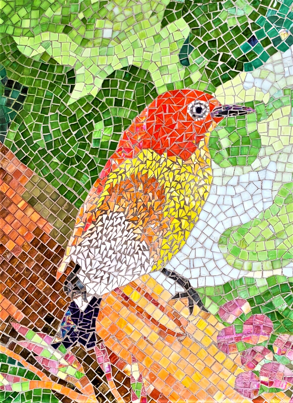
As we walked around, the next object of interest that we came across was what I first assumed to be a spectacular impressionistic mural:
But it isn’t a mural. It’s a mosaic!
…titled ‘The Tree of Life’.
We then walked over the bridge across the extension of Lung Ma Road (still a dead end), where I took a few more photos. The first is just a general view of the gardens there:
The walls separating the flower beds from the walkways are designed for sitting on.
This sculpture is titled ‘Beacon of Hope’:
It is meant to be a reflection on the many people who now live in the flats here, which are brightly illuminated at night. I believe that it is designed to also light up at night, so I shall have to check that out sometime.
And there is a basketball court, with floodlighting:
Finally, this is a photo of some flowers that I just thought were attractive:
I don’t know what kind of flowers they are, although they appear to have some significance that I can only guess at (see below).
Paula was busy on Saturday, so I decided to take a more systematic walk around the area to see whether I’d missed anything. I had!
This is the grand tour:
This roundabout, which marks the furthest extent of Lung Ma Road before construction had been completed, is the entrance to the estate:
Notice the logo next to the name of the estate. I think that it’s an abstract interpretation of the flowers that I included above.
And this is a view looking up the continuation of Lung Ma Road, showing the bridge over the road that links the two parts of the estate:
The building on the left is a school.
There is a cycle track that runs parallel to the road:
I have no reason to come this way on my bike, because pedestrians are a major hazard here.
This is the entrance to the shopping centre. There is another rendition here of the logo that I referred to above:
And this is a view of the ground-floor concourse from the top of the escalator:
All the big shops are here, including supermarket chain ParknShop and pharmacy giant Watsons.
I’d photographed one of the bronze plaques set into the paving that you can see in the photo of the canopy/sculpture above, but on my second visit I photographed one cluster of three plaques:
All three reflect aspects of Hakka culture (the Hakka, who speak a different language to that spoken by most Hong Kong people, migrated into this area during the Ming Dynasty (1368–1644). The surrounding rings are meant to represent tree rings, which in turn represent the passage of time. The entire installation is titled ‘Our Footprint’, and it occurred to me after I came home that I should have checked the other clusters of plaques, because I suspect that they will reflect other aspects of the history of the area (I did photograph one plaque on our earlier visit, which was titled ‘Fruit of Big-Leafed Fig’, a common tree hereabouts).
Another example of what I will call the ‘estate flower’:
…and another view of the canopy/sculpture:
I intended to take some more photos of ‘The Tree of Life’, but on the way I simply had to take a photo of this pine tree, which like the banyan (above) was probably transplanted from a nearby location, although I couldn’t find the relevant plaque to confirm this:
And this is what ‘The Tree of Life’ looks like in its entirety:
On our earlier visit, we turned back the way we’d just come after looking at this mosaic, but I noticed that there was an elevated section on the far side of a road that provides vehicular access for residents, so I wanted to take a closer look. This is effectively the perimeter of the estate, adjoining what I’d described in
Across the Swamp as ‘pristine forest’. And on one of the nearby site maps that I’d come across, there is a reference in the legend (not marked on the map) to a ‘woodland trial [
sic]’, so I wondered whether this forested area might be accessible.
But first, I was intrigued by the designs woven into the fence surrounding a small area whose purpose I can’t even guess at (it isn’t accessible):
From a distance, I thought that these designs, which represent common vegetables, were made from coloured string, but they are actually coloured wire and are very robust.
The forest is actually fenced off, but there are gates in the fence, currently padlocked, but there are paved paths leading to the gates, so I wonder whether the eventual plan is to construct some kind of woodland
trail for residents:
After I’d ascended to the next level, I took this photo of the large open area that includes the canopy/sculpture:
Some of the ‘Our Footprint’ plaques are clearly visible, and you can see the skyline of Fanling in the distance.
This is a view of the verandah leading to the bridge across Lung Ma Road, which passes what appears to be quite a luxurious Chinese restaurant:
We shall have to check it out sometime.
And this is a view from the bridge, looking uphill:
The green cars are New Territories taxis, which aren’t allowed to enter Kowloon, while the red cars are urban taxis, which can go anywhere but are more expensive.
The first thing you will encounter on the far side is this artwork, titled ‘Moments in the Woods’:
This is a collaboration between the artist and pupils from Fanling Government Secondary School. The plaque on the right includes a diagram showing which segments were the work of pupils (around 45 percent). All the wood used comes from Queen’s Hill Barracks, as does the wood used in these benches:
Another view of ‘The Beacon of Hope’:
This is part of what has been labelled ‘recycling path’, although I don’t understand the reference:
When I came to the estate with Paula, we turned around here, but on my subsequent visit I walked as far as I could, to be confronted by a staircase leading up to level three:
I didn’t find anything of interest on level three on this side of the estate, but I did take a couple of general photos of the estate on my way back to my original starting point:
I took this general view of the main shopping area from the top of the escalators on level two (note the ‘flower’ logo again):
Of course, I wanted to check out level three on this side of the road. There is another basketball court here (two, in fact):
…and even a table tennis table:
…while this is another view of the open area on level one, this time from level three:
When I descended to level one, I inadvertently went the wrong way, but it was a serendipitous error, because I came across the estate’s wet market. Naturally, I went in and took a few photos:
And outside, some more ‘estate flowers’:
Finally, here are two views of the estate from Lung Ma Road, looking downhill:
And that’s Queen’s Hill Estate. I’ve been in flats in public housing estates that were built in the 1960s and 1970s, which are quite spartan, but although I don’t expect to see the inside of any of the flats here, I imagine that they are a big improvement. And the amenities here are quite staggering, as you can see. These include a regular bus service to Fanling station, not to mention bus services to East Kowloon, West Kowloon and Hong Kong Island. I grew up on a council estate in England in the 1950s, and it was nothing like this.


I enjoyed the walk round there as I could see yhe creative work from schools as part of the co-construction of this enlightening living environment!!!
ReplyDeleteWe’ll undoubtedly be back, because it certainly is an ‘enlightening living environment’.
DeleteI wonder if that fenced-off area is intended to be used as allotment / community garden given the vegetable design on the fence? It looks like there is a small plaque on the right hand side of the gate (with a QR code), maybe it will explain more?
ReplyDeleteI wondered about that. I checked out the link you provided (below), and it does appear to be intended as some kind of communal garden/farm. I'll be checking this site when I come back from the UK in the autumn (and also whether any progress has been made with a nature trail through the forest).
DeleteIt is a community farm according to https://www.housingauthority.gov.hk/mini-site/queenshillestate/en/interweaving.html
ReplyDelete(From the site https://www.housingauthority.gov.hk/mini-site/queenshillestate/en/ )
I drove by that estate a few times during the pandemic and did not manage to stop and get in to take a look, so thank you for all the pictures and the virtual tour.
I remember your council house. It seemed to be huge and you had an indoor toilet. I was very jealous and thought that you were rich. I also remember the prefab that you had in the early fifties, that also seemed to be huge and for some reason I thought that it was an exciting place to live, visiting always felt like an adventure.
ReplyDeleteI don’t remember you telling me about any of this before. Of course, I do remember your flat in Farndale Road, which must have been pretty cramped, especially with five kids!
Delete