Friday 23 February 2018

another joke

Although I used to do so at least once a week, I haven’t ridden the journey to the west recently. In fact, when I did it with Paula yesterday, it was the first time since April last year. Naturally, after such a long absence, we couldn’t help but notice a few changes. The first obvious change has been to the link path, the key to the route during its initial exploration. What had once been a rough, nerve-racking section has been resurfaced, so there are no longer any lumpy bits, and the dodgy ‘bridge’, a photo of which I originally posted in Journey to the West: Part 2, has been eliminated entirely. We do not regret its absence.

The road leading to ‘the avenue of the dead’, which I described in Journey to the West: Part 4, has also been resurfaced, so that’s a few more bumps ironed out.

However, by far the biggest development has been the work being carried out alongside the Drainage Services Department (DSD) access road leading to Fairview Park (starting from the red ‘X’ in the southwest corner of the map below) and thence to the Kam Tin River. This will eventually become part of the much-trumpeted cycle track connecting Ma On Shan with Yuen Long.


The last time that I came this way, a short section of cycle track linking directly to the Yuen Long network was already under construction, and it is now complete. I thought that we might as well check it out, although I did notice that a few recreational cyclists ignored it and continued on the DSD access road alongside the Kam Tin River. I was almost immediately taken aback by a warning sign, which I made a mental note to photograph on the way back:


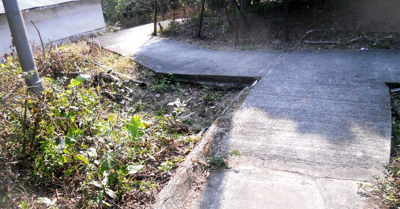
Steep road? I don’t think I stopped pedalling, let alone used my brakes. I’m not sure why the cycle track drops below the level of the access road, but the height difference is no more than 1.5 metres, and I would rate the hill as negligible, given that difference.

The previous photo shows the exit from the bridge over a small tributary stream looking north. This is the exit from the same bridge to the south:


The yellow bollards in both photos are probably there to encourage riders to slow down or even dismount but are merely a bloody nuisance. The person whose bright idea it was to install them is unlikely to be a cyclist.

On the other hand, I regularly see people riding bicycles who don’t know how to stop! I’ve lost count of the number of people I’ve seen who, having decided that they want to stop, take their feet off the pedals and slide them along the ground. I wonder what they think their brakes are for. You shouldn’t be putting your feet down until you’ve actually stopped.

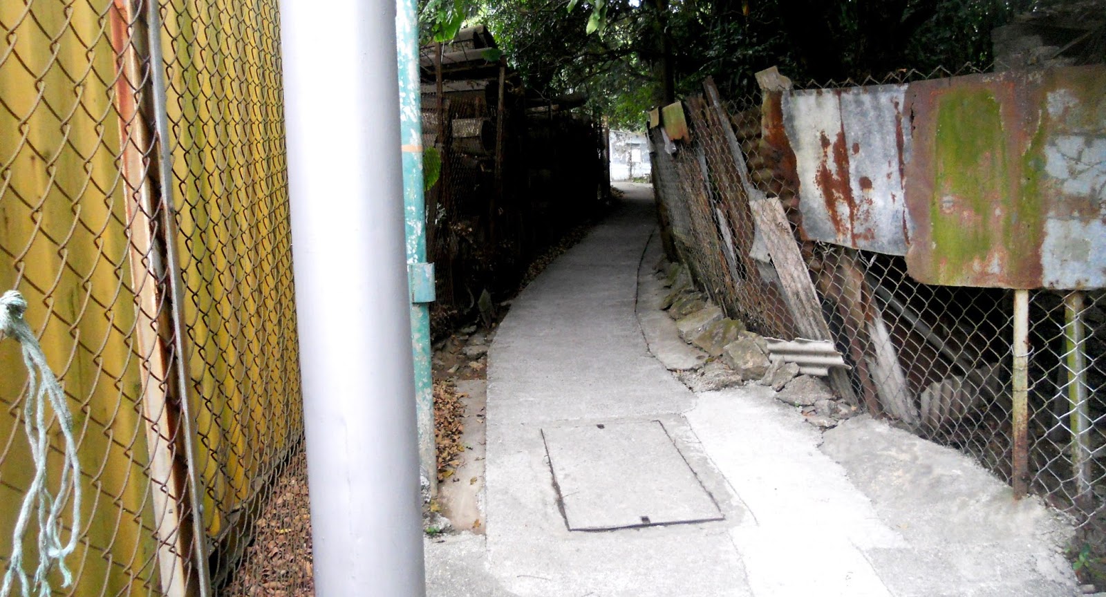
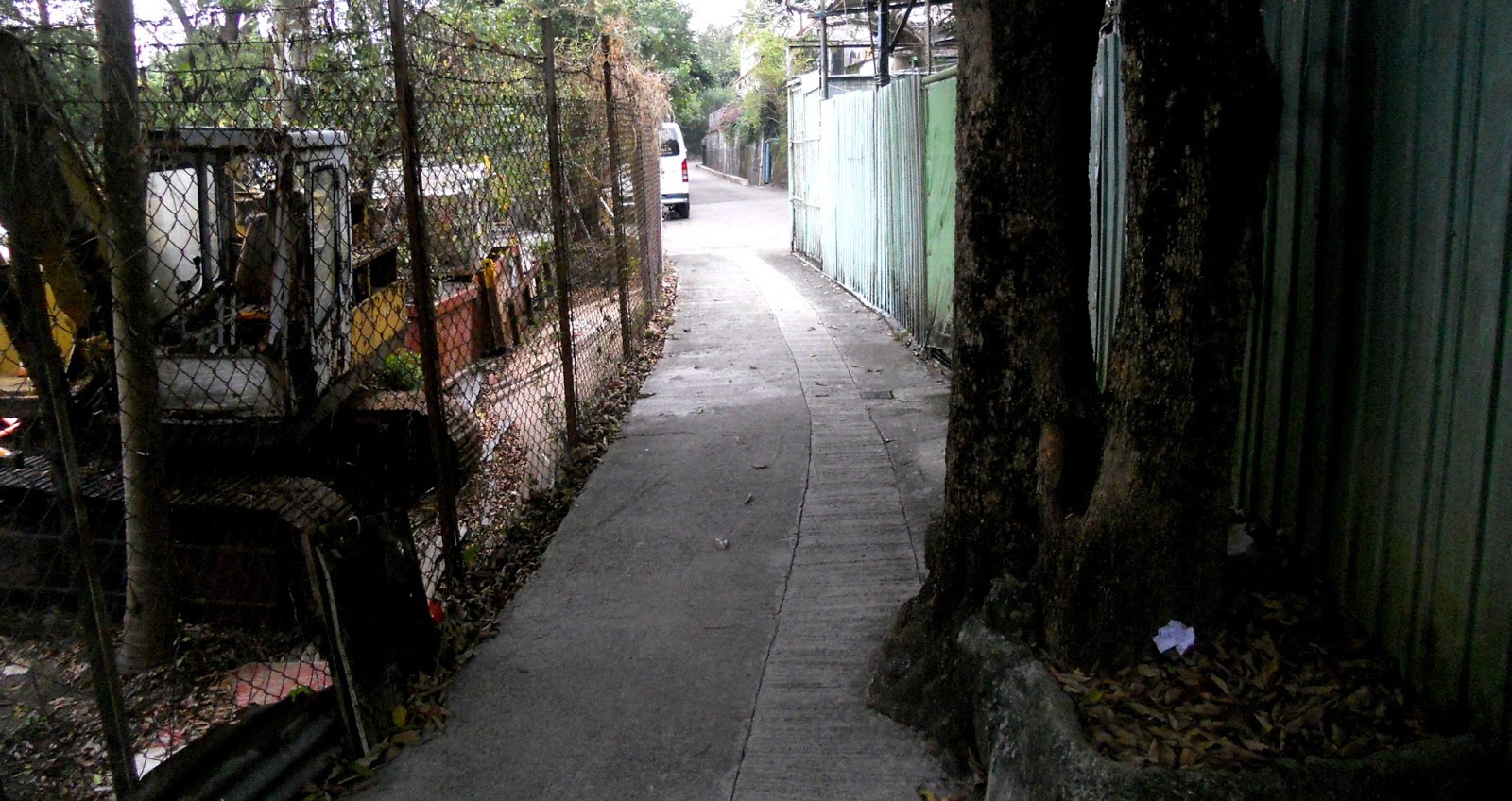
But if you think that the recommendation to get off and push is more than a bit silly in those two locations, what about this next example, a short distance to the north?


You may think that this is the joke referenced in the title of this report, but there’s an even bigger joke, and it’s not the least bit funny: this cycle track, from the red ‘X’ to the start of the Yuen Long cycle track network, is unnecessary. Millions of dollars are being wasted here, and on the cycle track running parallel to the Sheung Yue River (northeast of the second ‘X’ on the map above), because the DSD access roads in both places are perfectly capable of handling cycle traffic, particularly if the suggestions that I made in A Dangerous Arrangement for managing the DSD access roads around the Kam Tin River catchment are implemented.

And when the existing construction work is completed, there remains a big gap between the two X’s. I’ve no idea where the cycle track between these points is slated to go, but it must follow the general line of the expressway. There is a route through the large grey area to the south of the expressway, but it is quite mountainous, and “steep road, cyclists advised to walk” signs would be everywhere. But the crucial point here is that even if in the future it is deemed necessary to replace use of the DSD access roads with dedicated cycle tracks, why isn’t the X–X connection being built first?

To conclude, on our ride yesterday, it started to rain as we began our return journey, but we were keen to see whether there were any changes around fish pond alley. The rain became heavier as we rode through this area, so we decided to omit the Tam Mei loop. However, we did want to check whether anything had changed in the area of the snake path, because the last time that we’d come this way, the farmer had told us that major developments were afoot.

This is probably the only time that we’ve done the snake path in the rain, and I have to say that the wet conditions make it harder than usual. The turn onto the penultimate dodgy bridge was particularly harrowing, given that the bridge is bare metal, and the penalty for failure is a three-metre drop into the stream below. However, the really nasty section is shown in the following photo, which I took on our last venture through this area:


I took the photo because even then it seemed harder than I’d remembered. It may not look all that difficult in the photo, but the various surfaces are all at different angles, and the section next to the pond on the right of the tin shack looks like it’s about to subside into the pond. Well, when we tackled it yesterday, I swear that this section is now canted at an angle of 40 degrees or so—I certainly scraped my pedal as I rode across it. Paula was able to ride across via the left-hand section, but I suspect that my handlebar is too wide. Anyway, my wife suggested that next time we pass this way, I get off and push. Being a bloody-minded sod, I’m unlikely to comply, although that could mean that I end up in the pond.

And that would be no joke.

Friday 16 February 2018

dog day afternoon

As you probably already know by now, today marks the start of the Chinese year of the dog. However, I won’t tell you what that means, or what people born in dog years are like, because, like the Western zodiac, it’s all bullshit. To suggest that millions of people born in a particular year share personality traits beggars belief, even though millions of people do believe. After all, if it were true, I’d be just like Dim Damn Don, the bouffant buffoon currently occupying the White House, because we are, in astrological parlance, both fire dogs. And if I really were like Trumplthinskin, Paula would have thrown me out of the house years ago.

Chinese New Year is just about as late as it possibly can be this year, which may explain why it’s so warm. I used to joke that it was always cold at new year, and it certainly was last month, when at one point we hit 4 degrees on three days out of seven. And instead of being too cold for cycling yesterday, it was almost too hot, although Paula and I did complete the ‘four-hill challenge’ that I’d devised. Can’t have been hard enough.

Anyway, I don’t know whether it’s just my imagination, but every year the lion dancers seem to arrive in my village later and later in the day. This year, it was after one o’clock before they popped up on my doorstep, although they had spent an hour or so parading around the rest of the village beforehand:


The lion costumes have been laid out in advance, and the firecrackers are ready:


The lions are brought to life before the firecrackers are ignited:


You’re not supposed to start dancing yet (they must have been standing too close):


We always have a long string of firecrackers:


…and the biggest bang always comes at the end:


In the dance troupe, I didn’t recognize any of the regular members from previous years, apart from the two sifus, and it struck me that the dancers were inexperienced, which may explain why this year’s lion dance eschewed the complexities I’ve seen in past years.

Here are a few pictures:


I have only one other thing to add:

Lung ma tsing san.

‘May you have the strength of a lungma’, which you may well need in the coming year if the predictions of Chinese astrologers that I’ve read really do come true.

see also
A New Year
Enter the Dragon
Snakes Alive
A Horse with No Name
Sheep Thrills
Nuclear Chicken

Wednesday 14 February 2018

serendipity #3

I concluded Serendipity #1 with this photo of an alleyway leading off to the left from the main through route I was describing:


Although I would normally check out an alley like this on my bike, the next time I might otherwise have done so, it was far too cold to even think about cycling. But I wanted to take some photos, so this alleyway was actually explored on foot the first time I ventured down it, which explains Paula’s presence in a couple of the photos below.

This may look like a T-junction, but the apparent right turn leads immediately to a gate:


There is another apparent T-junction coming up, but on this occasion the left turn is the illusion:


We noticed some abandoned pig farms along this stretch, which you wouldn’t spot if you were riding a bike:


I often include photos in this kind of report not only to illustrate the route, which isn’t particularly difficult, but also to show some of the oddities I see along the way, like this discarded gas hob:


In fact, there is nothing technically difficult along the entire alley:


…before the path joins a rough track wide enough for motor vehicles:


The first time I came this way on my bike, I turned left and immediately found the way blocked by a truck that appeared to be loading stuff but was aligned across the track. I therefore turned right. The track went on for quite a distance but eventually came to a dead end, so I had to retrace my steps to the path described in Serendipity #1. The one good thing about this is that the turn onto that path is technically quite difficult because it is uphill.

The problem here is that this junction is what mathematicians call an ‘odd node’, which means that it is impossible to traverse this path, and the paths described in Serendipity #1 and #2, without retracing one’s steps at some point, unless, of course, one starts from and finishes at this junction, which is just silly. So, although I’m more likely to continue up that hill in the future, because it’s far more challenging, there is a reason why I could choose to follow the path described in this report. This is where the track emerges onto Ma Tso Lung Road:


The start of the alleyway that I described in Serendipity #2 is almost directly behind the camera! Coincidence or what?

Monday 12 February 2018

serendipity #2

Having discovered a more interesting (and safer) route between the end of the heart of darkness and the beginning of long tall sally entirely by accident, as I described in Serendipity #1, and because I’m always looking for opportunities to get off-road, I couldn’t help but scan the right-hand side of the road as I cycled south along Ma Tso Lung Road. It took about 400 metres after emerging onto this road (‘1’ on the map below) before I spotted this:


An alleyway this wide (‘2’ on the map below) has to lead somewhere, but where?


Notice the streetlight on the left in the next photo. That is always a good clue:


The next photo also contains a streetlight, but the point to note here is that there’s a T-junction (and a decision) coming up:


This is the right-hand option, although I checked out the left-hand option first. It was a dead end!


The next photo shows a modern, three-storey village house, which must have taken a lot of work to build, given that all the concrete will have had to have been barrowed in from Ma Tso Lung Road. The entrance gate is quite grandiose for this kind of location, although of course it doesn’t qualify for inclusion in the gates of delirium.


You will notice that the path is becoming narrower and slightly more broken:


The next photo is a good illustration of the sort of challenges that you have to deal with when exploring this kind of terrain. I initially took the right-hand option, for no better reason than it was the straight-on choice. Unfortunately, it came to a dead end within about 15 metres.

Usually, when this happens, I dismount, tip the bike up on its end, spin it through 180 degrees, get back on and retreat. However, this was an exceptionally narrow alleyway, and I ended up with my waist bag snagged on the wire fence behind me, while the knobbles on my front tyre prevented my front wheel sliding across the wire mesh fence in front of me.


Of course, I did manage to free myself eventually, but I should have turned left:


The next photo was taken from a point where there is a viable left turn, but I always take the long way round if I think it’s more interesting:


And it certainly is more interesting! You do need to have confidence in your brakes as you make the left turn in the second photo though:


…and to make sure that you don’t try to ride down the steps!

The rest of the path, which leads to Po Lau Road (second ‘2’ on map), is straightforward:


It may not be obvious from the photo, but the path just before it emerges onto Po Lau Road zigzags to the left then back right:


The first time I came this way, having checked that turning right led to a dead end, I simply followed Po Lau Road to its junction with Ho Sheung Heung Road. It was a Sunday, so there was little industrial traffic, but I realized that cycling 400 metres along this road during the week was a potentially dangerous option.

Fortunately, there is another way, which I might have spotted if I hadn’t originally turned right on Po Lau Road:


The start of this road is right next to where the path emerges onto Po Lau Road, and it leads directly to the start of long tall sally (‘L’ on the above map):


I’ve yet to encounter any traffic on this road, probably because there are no industrial premises—the fence on the right encloses land above the MTR rail line to Lok Ma Chau, except in the final photo, where it delineates the edge of a large nullah. The road is also mostly downhill, so you can take it at a decent speed. And if you think that finding a quiet road leading directly to the start of long tall sally was an outrageous coincidence, wait until you read Serendipity #3.

footnote
As is usual with Google Maps, almost the only roads are those with names. The rest are narrow alleyways. Perhaps the most egregious misrepresentation occurs at the ‘1’ on Ho Sheung Heung Road, where the ‘road’ to the southeast is actually the heart of darkness, while what I assume represents an alleyway across the road to the northwest is actually significantly wider (I described it in Serendipity #1, so you can compare the two).

Wednesday 7 February 2018

serendipity #1

When the Hong Kong government opened up the frontier road in 2013, there wasn’t a lot of ancillary terrain to explore. There was the turn into the village of Liu Pok at the start of the descent into the frontier area, and Ma Tso Lung Road, which starts halfway along the frontier road and leads, eventually, to Ho Sheung Heung Road. The first time I tried to follow this road, I encountered more and more heavy industrial traffic, and I decided that if I wanted to use this road on future bike rides, I would need to find a link between the two roads that meant I didn’t need to pass through the junction between them.

I had no trouble finding that link, although like so many segments of my bike rides, I discovered the link while exploring in the opposite direction to the way I now follow it. However, I no longer follow Ma Tso Lung Road from the beginning, because I prefer to continue along the frontier road to the Liu Pok turn-off. This means taking on Liu Pok Hill, which I described in Fortissimo #2 and which connects to Ma Tso Lung Road just after the crest of the hill.

This is the exit from the frontier road that I always follow nowadays, but a couple of weeks ago, when I arrived at the usual cross-link to Ho Sheung Heung Road, I found the way blocked by a huge flat-bed truck that appeared to be unloading a lot of stuff. I didn’t take a photo at the time, but this is the start of that link:


I could have waited until the unloading was finished, but my first thought was to wonder whether I could find an alternative link to Ho Sheung Heung Road, so I continued along Ma Tso Lung Road. This is the first possibility I spotted:


The streetlight visible in the second photo was an encouraging sign, so I took a closer look:


Naturally, I continued straight on, but after 200–300 metres, the road came to a dead end, so I was obliged to retreat. I might have ignored the right turn in the above photo (indicated by the sign with the red arrow), except that when I reached this point during my retreat, a truck was pulling out of this side road. I’d better take a look, I thought. At the time, I didn’t notice the other sign, which read “Private Road, Phoenix Garden”, or I might not have continued. I noticed a couple of quasi-industrial premises on my right, but eventually I came to the end of the road. However, there was an obvious alleyway:


I didn’t know what to expect here, but when the path started going downhill after a short distance, I knew that I must be onto something:


Not only does the path debouch onto Ho Sheung Heung Road, it does so almost exactly opposite the exit from the heart of darkness! Consequently, instead of riding along what is quite a busy road for about 200 metres to reach the start of long tall sally—and having to accept that drivers of big trucks will disregard your presence and pull out of the quasi-industrial premises on either side and force you to brake—the new route takes this path in reverse. The start of long tall sally is directly opposite the end of Ma Tso Lung Road.

This is what the route looks like in the direction I now take it:


You will have to wait for my photographic highlights post in May to see the remainder of the mural that’s visible in the last photo.

Straight on is the obvious choice, but the route actually turns right as it passes the gnarly tree in the distance:


There is an obvious left turn (see below) at the end of the industrial panels in this photo:


…although the following sequence records the rest of the original route:


The day after I found this connection, I cycled here with Paula to show her what I’d discovered, and on the ‘private road to Phoenix Garden’, we found ourselves behind an artic (US: ‘semi-trailer’), which was confronted by another artic coming in the opposite direction at the junction illustrated above. The two vehicles managed to sort themselves out, but where this side road joined Ma Tso Lung Road, there was an almighty traffic jam. I would love to know who was blocking whom, but I wasn’t about to hang around to find out when we could find a gap to sneak through.

I’ve now checked out the left turn referred to above, and this photo shows why I had to know where it leads to (a path this long and straight can't possibly be a dead end, can it?):

[
Serendipity #3 is a detailed report on this option.