Monday 30 April 2018

accidental tourists

Paula and I used to cycle journey to the west almost every Saturday, but mainly as a result of the new segments I’ve discovered this winter that have become integral parts of our Saturday ride, this once popular route has been neglected. However, we decided last Saturday to rectify this deficiency, to see if anything had changed. It had!

I described my initial exploration of the first part of the route in Journey to the West, in particular the problems that I found when, having descended from Saddle Pass (which is a classic pleonasm, by the way) and turned off to the left onto a dirt road, I struggled to find what I later named ‘the link path’. A couple of years after this initial exploration, I described how we discovered that the dirt road had been blocked by a gate of doubtful legality in Skullduggery. While this gate effectively blocks motor traffic on this road, it was possible to ride around the obstruction, although this option was extremely lumpy, making it hard to stay on the bike.

Not having done journey to the west since I’d acquired a video camera, it was my intention to record the key sections of the route, so the video was rolling as we turned off the Saddle Pass road. I’ve included stills from that video to illustrate what happened next:


The blocking gate can be seen just right of centre in the next still, but the well-defined track to the left wasn’t there the last time we came this way:


Wow! It looks as though this track has been here for ever:


…but I did notice where the previous ride-around went (behind the clump of elephant grass indicated by the red arrow). You will see it only if you look!


If you listen to the video soundtrack (link below), somewhere between the next two locations, I began to express doubts about being on the right track. Although I prefaced my comment with “I think…”, I knew we were going the wrong way, but I wanted to see Paula’s reaction.


She didn’t appear to notice that for a short distance, whoever constructed this track had used concrete, which by no stretch of the imagination is a cheap option.

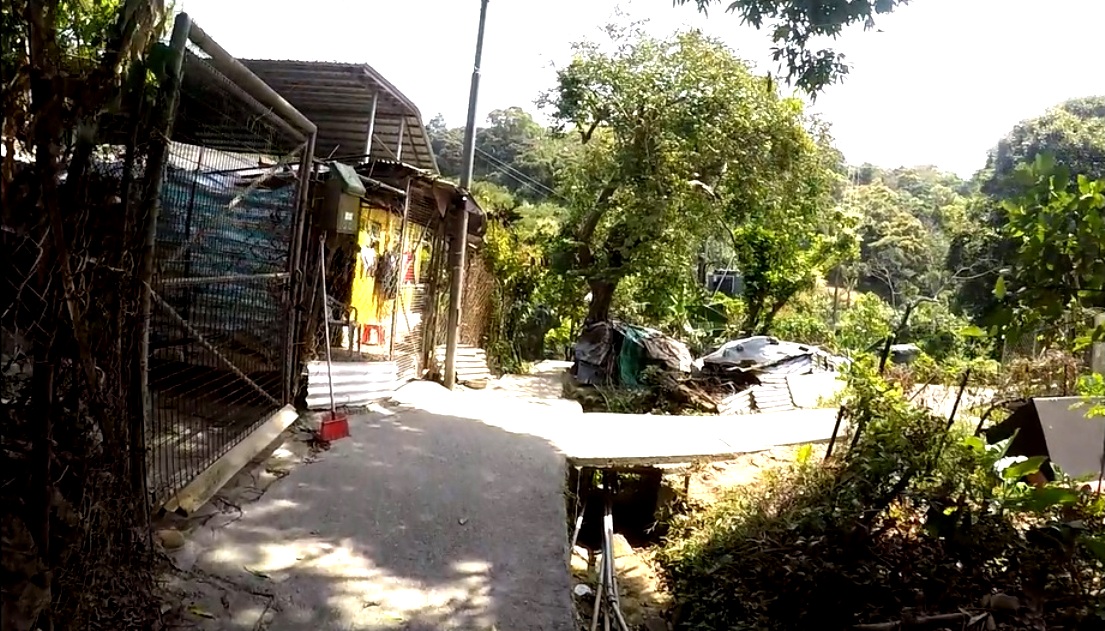
The next images show the approach to a potential junction. Paula told me afterwards that she was hoping to rejoin the original route, but she would have had to have turned right here for that to have any chance of happening. She turned left, although, to be fair, if you watch the video, you will see that there was some confusion at this point.


The road was becoming narrower, a possible sign that we were approaching a dead end:


Dogs are a recurring hazard when cycling off-road in the New Territories, although only a small number are actually dangerous. Many are extremely noisy, but these ones didn’t even bark!


The next image shows a second point where a road branches off to the right, but in this case Paula had no hesitation in turning left. By this stage, it was obvious that the track we were following wasn’t new (just look at the condition of the surface):


I shouldn’t, therefore, have been surprised when we soon found ourselves on a ‘proper’ metalled road:


We both had a sense that what lay ahead was somehow familiar, but we’d almost joined it before we realized that what we could see was the road descending from Saddle Pass on the right:


This is the full video:


Naturally, we followed the road again to the point where the video started, and this time we went the right way, although as you might guess from this still from the video I shot the second time, Paula took some convincing that this was indeed the right way to go. The original track can be seen between two concrete blocks at the end of this short link.


You may wonder why I’d never checked out the metalled road at the bottom of the descent from Saddle Pass, but the answer is simple: a blind corner to the right, with a short uphill section, means that you can’t afford to look left here. However, you can be sure that the segment described here will now become an integral part of journey to the west, albeit in the opposite direction to the way it was originally explored. And this may well be the only instance ever of a video recording of initial explorations, because I venture down dozens of tracks, paths and alleyways to see where they might lead, and the vast majority are dead ends, which there is no point in recording.

Wednesday 25 April 2018

hark! the village round

During my 2016/17 sojourn in Hong Kong, I developed a new bike ride that I called ‘the final frontier’—because it passed through an area that, until the beginning of 2016, had been part of the so-called ‘frontier closed area’. Exploring this new area meant venturing east from Fanling for the first time—previously, I’d always gone west.

However, it never occurred to me to look south of Sha Tau Kok Road (the main road out of Fanling to the east) until a couple of weeks before I was due to head back to the UK in May last year. In Reservoir Dodges, I described how I’d found an unexpected path that led to an area south of the main road that I simply had to take a closer look at. As part of that exploration, I followed one path that led back to Sha Tau Kok Road, which is a dual carriageway only as far as its junction with Ping Che Road.

I crossed to the north side of the road and followed a narrow lane and path as far as a Drainage Services access road (X on the following map):


As you can see, turning right only leads back to Sha Tau Kok Road. The road to the left is the kind of road that I ride only once. It leads to the Ping Che Service Reservoir, which is effectively a giant water tank at the top of quite a gruelling climb. Did I say “only once”? Naturally, I had to show Paula, and to make it really interesting, I pitched it as a ‘four-hill challenge’, the other three hills being the climb up to Hok Tau Reservoir, Hok Tau Road and Liu Pok Hill). This is by far the toughest of the four.

However, on this first visit to the area, I saw a much more obvious way to go:


I simply had to find out where the bridge over the drainage channel might lead to. It was certainly a good path:


As you have probably already noticed, the images I’m using to illustrate this excursion are not photographs but stills from a video, hence the distortion and, in some pictures, the crazy angles.

Solid yellow railings are always a sign that the path they border is going somewhere. But where? The first decision isn’t long in coming:


In my initial exploration, I chose to go straight on here, although as you will discover, I eventually returned via the right-hand path. And it’s all flat:


However, that is about to change. Radically! The ramp is not technically difficult, but it’s a lot steeper than it looks:


Around this point, I met a man who informed me that there was no way through. I’d like to see for myself, I replied. Keep to the right, he suggested. However, I kept left at the top of the ramp:


It’s the kind of question that I’ll never know the answer to: I have a vague feeling that the steps alongside the ramp weren’t there when I first came this way. The ramp was blocked a few weeks ago, I think for the concrete of the ramp to be renewed, and I now wonder if the steps were added then. The exit from the ramp seen in the previous image does seem easier now.

It’s still uphill though:


On my first visit, I continued up to the left:


…but it was a dead end, so I followed the path past the pavilion on the right:


The path here is obvious, contouring across the hillside:


…with one final uphill section:


…and a short level section:


…before an abrupt right turn:


The turn is an easy decision to make because, although it isn’t obvious in the picture, straight ahead is a flight of steps!

And it’s now downhill all the way:


You don’t want to allow your concentration to lapse here though:


…because the left-hand third of the path is a flight of steps!

There are no further difficulties, and we’re soon back on the flat:


The far end of the yellow railing in the previous image marks the junction seen in the fifth picture above:


And then it’s back the way I came earlier:


I’ve just described a circuit of the village of Wang Shan Keuk San Tsuen, which, as you have seen, is located on a hillside. The route follows the more westerly of the two paths north of the X on the map and returns via the more easterly. The path that connects the two is not marked on the map above, as I’ve come to expect from Google Maps.

San Tsuen means ‘new village’ in Cantonese, and I know of several such new villages in the Fanling area. I don’t know how or why such villages exist, whether they’re some kind of overspill from the ‘parent’ village, which is always located nearby. In this case, Wang Shan Keuk is located between Sha Tau Kok Road and the X on the map, and I do have to say that I find siting an overspill village on a hillside rather than on a flat area strange. It must be quite new though, because until 40 years ago New Territories villages were self-sufficient in rice, and there is nowhere here where rice could have been grown.

Finally, give yourself a bonus point if you spotted the Steeleye Span reference. Hark! The Village Wait is the title of an early album by my favourite folk band. I always do this round nowadays whenever I’m in the area, but to paraphrase Doctor Johnson’s assessment of the Giant’s Causeway, it may be worth doing, but it probably isn’t worth the trouble of going to do. After all, it doesn’t actually go anywhere.

Friday 13 April 2018

squatters’ rights

Last summer, a friend in Penrith, my home town in the UK, told me that he’d watched a TV documentary about Hong Kong, and he expressed surprise that shacks and shanties were still to be found here. A couple of years earlier, a friend who’d been a high-ranking government official during the British administration was equally surprised to see the squatter huts around where I live.

Of course, the huge squatter areas of the 1970s in town, such as Diamond Hill, are long gone, but a lot of impromptu dwellings exist out in the New Territories. However, I must confess to being ignorant of the legal status of squatters until the first day of 2018, when Paula and I were doing our favourite bike ride, the long and winding road. At one point, we found that the path we usually follow was blocked, and in the course of navigating a detour, I spotted a sign that contained a lot of writing. I stopped to take a look.


All the structures in this photo are squatter dwellings, except, possibly, the three-storey building on the right.

I’d seen signs related to squatters before, notably the one announcing that a given slope is subject to landslide risk, and some dwellings have been scheduled for clearance. This one was different. There were a lot more words for a start, and I thought that these were worth recording:
  1. Squatter structures existing before 1982, as well as their uses, were surveyed and recorded by the government.
  2. Change in the use or unauthorized extensions will lead to demolition of the squatter structures concerned.
  3. New erections of squatter structures will be demolished, and offenders may be prosecuted.
  4. Residents are advised to contact their respective Squatter Control Offices for appropriate advice on any repairs before commencement of works to ensure that the works accord with the requirements.
  5. A territory-wide squatter occupancy survey was conducted by the government in 1984/85 whereby the squatters were registered. Coverage by this survey is one of the eligibility criteria for public rental housing when squatters are affected by clearances. However, the survey does not confer any right to anybody for the occupation of government land.
  6. Purchase of squatter structures is not protected by the law nor confers any rights to their occupants on clearance. Therefore, DO NOT purchase any squatter structures.
  7. Unauthorized occupation of squatter structures recovered by the government is liable to prosecution and eviction.
  8. If in doubt, please contact the District Squatter Control Office.
I frequently cycle through squatter areas, and I’d already noted that squatter dwellings have piped water and mains electricity connected, but I knew little else about the legal status of such structures, so this sign was quite an eye-opener.

Despite Article 3, I see new structures going up all the time, although any long-term resident of Hong Kong is unlikely to be surprised by my statement. For example, this fine house, located on the frontier road, is unlikely to have been built—and therefore surveyed—before 1984/85 (Article 5):


Although you cannot see them, there are four air-conditioning units on the right of the building, and three on the left, so it’s a fair guess that the interior will be surprisingly luxurious, even though the walls are merely industrial panelling. Note too the sign in front proclaiming government ownership of the land. I see scores of these signs, and as in this case they refer to a narrow strip of land that has been so designed to constrain development around it. It doesn’t refer to the land on which the house has been built.

However, it’s not difficult to find examples of squatters blatantly ignoring such signs:


I took this photo just a short distance from my house on the eastern outskirts of Fanling.

I should comment on Article 6, which admonishes readers not to purchase squatter structures. I know of at least one confidence trickster who scours the countryside looking for structures that have been abandoned. He renovates them and sells them on. Welcome to the Wild East.

Since discovering that first sign, I’ve noticed quite a few more, although there are none within easy walking distance of my house. This is the nearest, and also the first that I found, at the junction of Po Kat Tsai Road and Lau Shui Heung Road:


The curious thing about this location is that there do not appear to be any squatter dwellings in the immediate vicinity, although there are a lot of what I’ve described elsewhere as ‘quasi-industrial units’. I’ve since spotted a couple of signs east of Fanling in another area where there are only such industrial sites, and I now begin to wonder about the legal status of such premises.