Monday 31 January 2022

an educational excursion

For the past couple of weeks, I’ve been out and about looking for new examples of my favourite floral display of the year: the firecracker vine. I’ve also been visiting some of the locations I already knew about in the hope that I might be able to take some better photos than the ones I already had.

Consequently, I decided to visit the location of what I consider to be the finest single example of a firecracker vine in bloom that I already knew about (check out the first photo in Jeepers Creepers #2 to see what I mean) one day last week. This location is about 6km downstream from our village, just before the Ng Tung River flows under the main railway line into China (when the border is open), so I planned to take in a few detours as part of what was clearly going to be a long walk.

Having left behind the construction area that currently blights the upper section of the river, I decided to cut away from the river to walk through the village of Wa Shan in the hope of spotting some new examples of firecracker vines. There were none here, but I did spot one in the distance, in what is clearly a forested area:
The pink in the foreground of the first photo is provided by bougainvillea.

I wondered whether I could get a closer shot, because this vine was likely to be near ‘the top road’. I could, although there was too much vegetation for an ideal photo:
Although firecracker vines are usually to be seen adorning the perimeter fences or walls of people’s gardens, this one was clearly a wild example. Unusual, but not unique, in my experience. I wondered whether it was an escapee from someone’s garden, or whether this was its natural state.

I returned to the Drainage Services Department (DSD) access road I had been following and continued downstream. Having crossed Man Kam To Road, a major highway into China (when the border is open), I decided to have a rest at the next covered seating area, kindly provided by the Home Affairs Department despite DSD ‘keep out’ notices. When I continued, almost immediately my ears pricked up. That sounds like goats, I said to myself, so I walked over to the side of the road to see whether I was right. I was:
I also shot a video:


My first thought was “how did they manage to cross Man Kam To Road safely?” Then I realized. This was a different herd to the one we often see upstream from this highway, almost all black, with just one white individual—the other herd includes several white and brown individuals. I followed the herd as it browsed slowly along, until it reached the area in the fourth photo, which apparently had enough to eat for them to pause for a while. I continued on my way.

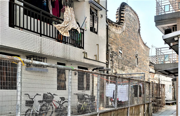
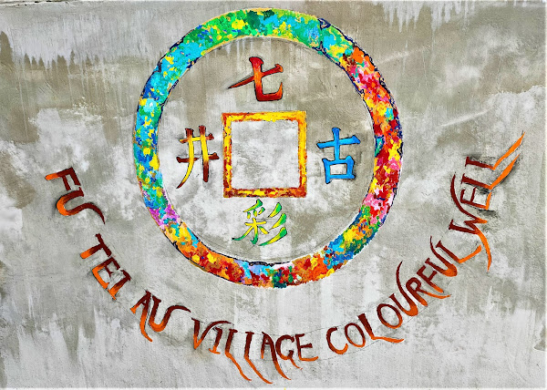
Opposite the first footbridge across the river downstream from Man Kam To Road, there is a path that leads through a large cluster of small houses, eventually emerging onto Fu Tei Au Road. I’ve often cycled through here, because it provides quite a stern test of one’s bike-handling skills. However, this was the first time I’d been here on foot, and therefore the first time I noticed this memorial stone:
Although it’s difficult to read after more than half a century, it commemorates a catastrophic flood in 1964, before the river was canalized, and the subsequent rebuilding efforts, which included this rather quaint brick-arch bridge over the connection between two large ponds that are currently covered in dead water hyacinths:
This path leads eventually, through quite a few twists and turns, to the firecracker vine that was the original motivation for this expedition:
The target vine is on the left; there was no vine on the right when I took the photo that I included in Jeepers Creepers #2.

This is a view looking down the path from Fu Tei Au Road:
The floral density of the vine on the roof is almost solid, but there were many more flowers above and right of the gate when I took the earlier photo. The building in the right middle distance is the Sheung Shui abattoir, the final destination for thousands of pigs from China every day.

Having taken several more photos here, which will be published later this week as part of this year’s survey of firecracker vines, I continued along Fu Tei Au Road to where it is joined by the DSD access road. My intention had been to cross a footbridge here and follow a footpath that runs alongside the slaughterhouse, but as a result of construction work here, unrelated to the construction in our neighbourhood, the path was blocked, so I had to backtrack along the DSD road instead.

This turned out to be a serendipitous move. After a short distance, I knew that I could join a path that runs parallel to the DSD road, and almost immediately that I did so, something in the distance caught my attention. From that distance, it appeared like printed material, because the colours were so bright, but it turned out, unexpectedly, to be a fascinating mural painted onto a brick wall:
It’s well worth taking a closer look:
I hadn’t realized at the time I took the photos that this is one contiguous scene, although I did notice that it was painted across a buttress in the wall, and the next buttress along was unpainted, thus separating this scene from a completely different scene further to the right.

You might think that the calendar on the wall is displaying a completely arbitrary date, but thanks to the plethora of homophones in the Chinese language, ‘two three’ sounds like ‘easy to accumulate riches’. The character on the calendar means ‘blessings’ and is seen everywhere around the time of the new year. This is clearly a new year scene, given the four-character invocations pasted on each side of the window. The one on the left means ‘one group happy’ (implying no arguments), while the one on the right means ‘plenty of money’.

Other things to note in this scene: the boy on the right is busy doing his homework, but the boy stealing around the buttress in the foreground, who should probably be doing his homework too, is more keen to join the two smaller children playing marbles. Note too the old-fashioned cathode ray tube television, and the collection of (presumably empty) wine bottles on the top shelf.

The right-hand painting is even more intriguing:
This photo was taken two days after my initial visit, partly because I’d inadvertently chopped quite a lot off the right-hand side of the image because I couldn’t get far enough away, given the width of the alleyway here, but mainly because I wanted Paula to see the mural (we waited two days because we’d planned to go out cycling on the intervening day, and given the dubious weather recently, that was a date that couldn’t be changed).

Paula was particularly amused by her observation that while the humans in this image are working hard (threshing rice, polishing rice, harvesting vegetables, fishing), the cat and the cow are taking it easy:
Incidentally, I haven’t seen rice being grown in Hong Kong since the 1970s, although I do recognize the threshing box being used to separate the rice grains from the rest of the plant.

It was only when I looked at the photo after we got home that it occurred to me that although it looks like a domestic pussy cat, the animal on the left is actually a tiger (and it’s slurping an ice cream cone), and cows are oxen (this cow is sipping a milk shake). And we are about to exit the Year of the Ox at midnight tonight, to be followed by the Year of the Tiger. So this part of the mural also has a new year significance, and I think that it must have been painted very recently, given the freshness of the colours.

By the way, I can’t explain the fish swimming in a pink sky, so if anyone can, please leave a comment.

Another thing I didn’t notice on my initial visit, but Paula did:
Easy to miss if you’re walking towards the camera: the sign reads ‘seven colours [rainbow?] ancient well’. The arrow points up a narrow alley, and of course we had to see where it led. It turned out to be a proverbial ‘blind alley’, but I noticed this painted plaque on one sidewall, just before the end:
The characters are the same as on the arrow, reading top, bottom, right, left. And the well is located in the left-hand corner at the end of the alley, surrounded on the two open sides by stainless steel railings:
Clearly, this well is no longer used as a source of water, but I wonder why it was considered ‘colourful’. I can only conjecture that evaporation of water from the well, combined with refraction of light through water vapour, somehow created a rainbow effect. I also wonder why its existence is both signposted and commemorated by a plaque, especially as very few people pass this way, even on the DSD access road. And I didn’t realize that Fu Tei Au is a village—there are no modern three-storey village houses here, or a public toilet—although perhaps I should have guessed, given that named roads in the New Territories tend to lead to wherever the road is named after.

I wasn’t about to return home the same way, so I crossed the river via the footbridge opposite the memorial stone, which leads to the road into the abattoir. I wasn’t paying attention, but when I came this way with Paula, she quickly spotted a truckload of pigs on their final journey. After that, I counted four more trucks carrying doomed pigs in the five minutes it took us to reach Po Wan Road. I may not have been paying attention to traffic on the road, but I couldn’t help but notice this on the opposite side of the road:
The question is almost too obvious to ask: how do you polish effluent? The logo on the right is that of the DSD. And there is another question. The boundary here appears to be a hedge, but notice that the letters are quite wobbly. How were they fixed to the hedge, which doesn’t appear to have obscured a single letter?

The rectangle on the left appears to be a site map superimposed on an aerial photograph:
I think that there may be other intriguing mysteries and talking points further left along the boundary fence, so I will probably be back at some time to take a closer look.

Meanwhile, on Po Wan Road:
I was tempted to shrug and say to myself “well, this is Hong Kong!”, and at least there is almost no traffic, but it isn’t possible to cross to the other side until the road changes from a dual to a single carriageway. And these are big articulated wagons blocking the pavement. I wonder how often the police check this road for illegal parking.

After a short distance along Po Wan Road, it’s possible to detour into a park next to the moat around part of Wai Loi Tsuen, which I wrote about in Historical Sites in Sheung Shui, where I came across this structure:
Gazebos are common in small parks all over the New Territories, but this is something rather more grand. It obviously has a religious significance, hence the rectangular box filled with sand, used to plant burning joss sticks, and the square structure on the left, used to burn paper representations of useful objects, like a motor car, that a deceased person could use in the afterlife.

Incidentally, you may think that the swept-up profile of the roof is a mere idiosyncrasy of Chinese architecture, but if a flying demon lands on the roof, it will slide down the roof and be swept back into the air. Makes sense.

My route home then follows a path between the moat and the houses where the walls of Wai Loi Tsuen, which were around 8 metres high, once stood:
Admittedly, I took this photo, looking back the way I’d just come, for the bougainvillea rather than to illustrate this excursion.

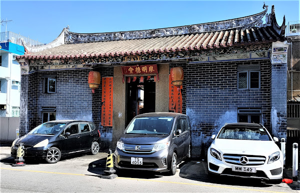
And I took this photo of the Liu Man Shek Tong Ancestral Hall as evidence that we were indeed approaching the new year:
Notice the pots of kumquats, popular at this time as a symbol of prosperity, and the pots of yellow flowers on each side of the door, which are probably chrysanthemums.

Having encountered a previously unknown herd of goats on my outward journey, it was probably inevitable that we would bump into our local herd when I repeated the route with Paula:
We actually spotted them some distance downstream, but they were herded along by a couple of day trippers in cars—the pre-construction route was inaccessible to motor vehicles. They would probably have wandered off to the right much earlier than they did, and when they did squeeze through the gaps in the barriers, they would have faced a barren landscape with almost nothing to eat.

At least I could have a cold beer when I got home, which isn’t far from where this last photo was taken.

Thursday 20 January 2022

egad! extraordinary egret expanse

Egrets are very common in aquatic environments in Hong Kong, especially around the fish ponds along the border west of Fanling and in the Kam Tin River—but only at low tide in the river. We frequently see groups of 30–40 individuals in the Kam Tin River, but we were unprepared yesterday for the sight that confronted us as we cycled along San Tin Tsuen Road.

This road, which circles around the northern and western edges of the group of villages collectively known as San Tin, carries so little traffic that there’s a point where we always encounter three or four dogs sleeping in the middle of the road! San Tin is worth a visit because it contains several historical buildings (New Fields), but we invariably follow this bypass because our objective lies much further west, and the design of the recently completed cycle track connecting Sheung Shui and Yuen Long, which avoids San Tin to the south, is a disjointed dog’s breakfast, so we use it only where we haven’t been able to find an alternative.

We’d started yesterday’s bike ride east of Fanling so that we could follow the Hok Tau country trails, after which we decided to continue along what we always refer to as ‘the frontier road’ on our way west. I’d described this road, which used to be another quiet ride with minimal traffic, as ‘like a rural cart track’ in a recent post as a result of damage caused by heavy construction vehicles, to be avoided if possible, but while I was out of action last month, Paula had ridden along it and reported that the damaged sections had been resurfaced, so I wanted to see whether that meant we could start using it again. We could.

From the western end of the frontier road, it’s necessary to follow Lok Ma Chau Road, which leads to a major crossing point into China, and it usually carries a lot of high-speed traffic, but the border has been closed since the start of the pandemic, and we’ve been using it during this period. We shall have to find an alternative once the border reopens though.

Anyway, the next section is San Tin Tsuen Road, which you can see on this map:
When we reached the fish pond marked by an X on the map, we were staggered to see hundreds of egrets. The pond had been drained—the egrets wouldn’t have been there otherwise—so we stopped to take a few photos. This is a view of the northeastern corner of the pond:
Not an exceptional number of birds here, or so you might think, but there is a high wire-mesh fence between the pond and the road, restricting the view. And there is quite a lot of vegetation in the way, although I deliberately included the bougainvillea in the next photo because, well, I like bougainvillea:
Despite the trees, you can get some idea of how many egrets there were here from this photo:
Having taken the previous photos, we continued on our way, but within a short distance the vegetation on the bank had been cleared, and we could therefore get a better view, so we stopped again:
Like all the photos I took yesterday, the previous photos are the view looking northeast.

At this point, Paula asked a question:

“Why are there so many egrets here?”

I thought that she was looking to me for an explanation, but she’d just spotted several fish floundering around the edge of the pond, which clearly didn’t have enough water for them to survive indefinitely. And they were therefore easy prey for the egrets—the avian equivalent of shooting fish in a barrel.

All the remaining photos are general views of the pond followed by enlarged versions of the area of interest. This is the first:
…the second:
…and the third:
As I mentioned, one of the reasons that I was able to take such clear photos of the egret population in the pond was the absence of vegetation on the near bank, but there was another factor—only in Hong Kong. There were a couple of chairs next to the fence—we’ve often seen people sitting there—and by standing on one I was able to position my camera above the fence. The first photos above were taken with my camera held at arm’s length above my head!

There was just one minor disappointment. Although we usually continue beyond the end of San Tin Tsuen Road, our intention this time, because we’d started ‘out east’, was to double back once we’d reached the end of the road. As we approached the western corner of the pond, we spooked more than a hundred egrets, which immediately took flight. I’d love to have captured that on video. Maybe next time.

Wednesday 12 January 2022

historical sites in sheung shui

When I wrote about a morning walk a couple of weeks ago, I mentioned that we had detoured through northeast Sheung Shui on the way home because I knew that there were historical buildings in the area that Paula hadn’t seen, but I also wrote that a detailed account of these buildings would be held over for a separate post. Well, this is it.

Whenever we cycle out west, we have to negotiate an underground cycle track interchange that corresponds with the junction of Jockey Club Road and Po Shek Wu Road, both of which carry heavy traffic. The interchange is effectively a T-junction, and when we turn off the cycle track that runs alongside Jockey Club Road to come down to the junction, we turn left to follow the cycle track that runs alongside Po Shek Wu Road. You can see the roundabout that marks the road junction towards the southeast corner of this map:
I used to wonder where a right turn at the T-junction would lead to, and one day, a few years ago, I decided to find out. In fact, the cycle track comes to an end the moment it reaches ground level, but it continues as a narrow lane, so I followed that. This is the first building of interest that I came across:
This is the former Sheung Shui police station, which was built in 1902, three years after the signing of the lease that granted Britain control of the New Territories for 99 years. It is now a Junior Police Call clubhouse. Except where indicated, all the photos that I’ve used in this post were taken during our recent visit, and I didn’t recall seeing it during my earlier exploration, but when I looked at the photos that I took during that initial visit (see below), I found that I had indeed photographed it then. Incidentally, Fanling and Sheung Shui were once separate population centres, but they are now contiguous, and I've no idea where the boundary between the two is located, but the modern-day Sheung Shui police station is actually in Fanling!

The entire area is filled with densely packed village houses—a legal definition stemming from the 1972 Small House Policy, which stipulated that any male who could trace their descent, through the male line, to males who had lived in the area prior to 1898 had the right to build a house, a right known as ding. The policy also stipulated that such houses must be no more than three storeys high, with a maximum footprint of 700 square feet. The stated aim was to improve the housing stock in the New Territories, although I had always thought that it was intended to halt the depopulation of the New Territories.

As you might guess, the policy has always been controversial, not least because it was blatantly sexist. It has also been fertile ground for corruption. In the village where we lived between 2005 and 2008, the native villagers scoured Europe to trace former residents of the village who had emigrated to work in Chinese restaurants there. No need to come back to Hong Kong: we will make an application on your behalf and build the house; then, when we sell it, we will forward you the money, less commission. The houses in that village were built very close together, albeit nowhere near as close as the houses in the area I’m describing here. You can see what I mean by a quick glance at the following satellite photo:
There are no fewer than nine ‘separate’ villages in the relatively small area northwest of the roundabout, although you would be hard-pressed to locate any boundaries between them nowadays.

Continuing north from the former police station, the next point of interest is the Liu Ming Tak Tong Ancestral Hall:
It was originally built in the early nineteenth century, but—I didn’t know it at the time of our recent visit—it was completely demolished in 1972 and rebuilt the following year with only the granite door frame retained from the original structure.

The next photo shows the dong chung, the wooden panel just inside the doorway that is there to prevent the ingress of evil spirits:
…and this is the central courtyard:
The rear hall of an ancestral hall always contains what are known as ‘soul tablets’, the earthly representations of important former members of the local clan:
Each horizontal row represents a single generation.

Notice the blue panels on each side of the soul tablets. This is a closer look:
They depict a phoenix (on the left) and a dragon (on the right), reflecting the female and male principles, respectively. At least I thought it was a dragon when I took the photo, but when I looked at the photo later, I saw that it is in fact a lungma, a cross between a dragon and a horse, although it doesn’t look remotely fierce, as these mythical creatures are supposed to be.

Directly in front of the Liu Ming Tak Tong Ancestral Hall is another historical building, facing in the same direction. At the time of my original visit, this hall was closed, and all I could do was photograph the door gods. I identified it as the Liu Ying Lung Study Hall, probably from Wikipedia, which still holds to this definition, but as you will see, it’s more like an ancestral hall. Study halls, which were once used to prepare candidates for the imperial civil service examination, didn’t have ceremonial drum platforms on each side of the entrance. It was built in 1838:
And this is the dong chung:
…while this is the central courtyard:
I did wonder about the reason for all the plastic stools, although it was obvious that their purpose was to prevent visitors from entering the area they enclosed. In fact, the roof is currently in quite a parlous state:
This is a look inside the rear hall:
Unlike the Liu Ming Tak Tong Ancestral Hall, this hall also features soul tablets in the alcoves on each side of the main shrine. These are usually reserved for clan members who have excelled in virtue (on the left), or made an important contribution to the clan or attained high rank in the imperial court. On that basis though, the three ancestors commemorated in the right-hand alcove must have been really high achievers:
Notice the object in the bottom right of the photo. I thought it was worth a closer look:
It appears to depict a line of people lining up to pay homage to the seated man on the right, although the man who is first in line is wearing a winged hat, a sign that he is of high rank in the imperial bureaucracy. And he appears to be holding a glass aloft as if proposing a toast. I’ve no idea why the woman is wearing what appears to be a feathered headdress, but the short man behind her is clearly striking an aggressive kung fu pose. The line of supplicants extends through the doorway (the absence of heads probably reflects damage rather than anything sinister).

Continuing north from the two ancestral halls, the next place of interest is Sheung Shui Wai (wai is Cantonese for ‘walled enclosure’). This is the southern entrance:
Although the label ‘Sheung Shui Wai’ appears to have been extended to almost the entire area, this is the only genuine wai hereabouts. It’s incredibly small (only about 20 metres square), and there isn’t a gatehouse, but it does feature a traditional bow-shaped Chinese gable end to a house just right of the entrance:
And there’s another on the opposite side of the wai:
…while this is the north entrance:
From this entrance, it’s possible to see the rear of the Liu Man Shek Tong Ancestral Hall, which was built in 1751:
I’ve used the photo I took on my earlier visit because the hall is currently undergoing extensive renovation, and the elaborate doorway on the left, which provided access to a narrow alleyway running alongside the hall, appears to have gone.

I took the following photo of the front elevation on a subsequent visit (see below) to take more photos. I’ve preferred it to the one I took when with Paula because this hall, as the only ‘declared monument’ in the area, is closed on Tuesdays, and this photo therefore shows the door gods:
Because of the renovation, we weren’t able to access the second and third halls—the view from the entrance across the first courtyard is just bamboo scaffolding and industrial sheeting, so I couldn’t take more photos inside, but this is the dong chung:
However, there are attractive friezes directly above the drum platforms on the front of the hall:
I’ve rotated the images to provide a better view, first on the left:
…and then on the right:
As you can see, they are traditional Chinese landscape paintings.

A short distance from the front of the Liu Man Shek Tong Ancestral Hall is a feature that I didn’t recall seeing on my earlier visit:
This is the gatehouse of Wai Loi Tsuen. According to Wikipedia:
Wai Loi Tsuen is a walled village.
No it isn’t! It was a walled village, but apart from this gatehouse, and a back gate:
…absolutely nothing now remains of the walls, which were probably demolished at some time during the past fifty years to make room for new houses. Judging by their designs, most of the houses around the perimeter were built after the introduction of the Small House Policy in 1972, although I did spot a two-storey house with a carved date plaque of 1968—putting the date on the front elevation of a house was a common practice in the 1950s and 1960s. I’ve seen a photograph, taken in 1950, that showed the walls, which looked imposing, although you can get some idea of how high they were by looking at the photo of the gatehouse.

Wai Loi Tsuen is the area’s original settlement, probably established in the sixteenth century. The walls were built in 1646/47. Unusually, however, the village still retains part of its original defensive moat, which is the crescent-shaped body of water on the above map:
I’d seen this on my earlier visit, but I’d assumed that it was merely an ornamental lake—there’s a park on the other side of the water from the village, and such lakes were a common feature of Victorian urban parks in England. However, it’s rare for defensive moats to have survived. The wai in the village where I live is surrounded on all four sides by car parks, because you can make money by filling in the moat then charging residents to park their cars.

Unlike Fanling Wai, where the central alley from the gatehouse to the rear entrance is distinctly claustrophobic, the central thoroughfare in Wai Loi Tsuen qualifies as a lane:
…although all the side alleys are a tight squeeze:
*  *  *
There’s a curious postscript to this story. A few days after our visit to the area, Paula and I were walking past the Tsz Tak Study Hall, near Fanling Wai. The doors of this hall are always closed, and as we walked past, I glanced at the door gods. I thought immediately that they had changed. The unconventional weaponry being toted by these ‘guardians at the gate’ hadn’t changed, but there was definitely something not quite right.

Consequently, when we got home, I checked my archives. I’d included a photo of these door gods in More Door Gods #2—and they had indeed changed—but I noticed that, in addition to the door gods on the buildings I’ve described above, I’d also included a photo of what I’d labelled ‘temple in sheung shui’ in this collection. I had a vague memory of photographing four pairs of door gods on the same day, so I went back to the area to look for this elusive temple, without success. But I did find the ‘temple’ when I returned home. When I looked at the other photos that I’d taken in May 2015, I realized that I’d also taken the photo of the door gods guarding the Tsz Tak Study Hall on the same day. And then it dawned on me: I’d mistakenly identified the Liu Ming Tak Tong Ancestral Hall as a temple. I hadn’t known that it had been demolished and rebuilt, and it certainly doesn’t look like an ancestral hall—ancestral halls don’t have windows, and there are no recessed drum platforms.