Saturday 28 January 2017

nuclear chicken

If you’ve been watching BBC News, then you will know that the year of the monkey came to an end at midnight on Friday, to be superseded by the year of the rooster. Except that this is ‘fake news’ (or an ‘alternative fact’ if you prefer). As happened two years ago with the year of the sheep (or year of the goat—the Chinese language does not distinguish), which was frequently announced at the time as ‘the year of the ram’, the commentators have fallen into the trap of seeing the animals of the Chinese zodiac in gendered terms, which is incorrect.

You may be wondering about the title of this post. Chinese astrologers will tell you that following the generally lighthearted mischief that characterizes years of the monkey, the world is heading into darker times. Although most people will be aware that there are twelve animals in the Chinese zodiac, not so many will know that the astrological cycle actually takes sixty years to complete, because overlapping the cycle of the animals is a cycle of the five elements. And this year is a fire year. There will be turbulence. There will be turmoil. And there will be trouble.

I’m not basing this assessment on astrology, which is complete hogwash, but on the new geopolitical climate following accession to the throne of Donald J. Trump. And nothing is more pressing in that sphere than the possible use of nuclear weapons. It is not a coincidence that the Bulletin of Atomic Scientists advanced its Doomsday Clock by two minutes last Thursday, and it is now at the latest it has been set since the end of the Cold War (three minutes to midnight). Trump has already stated that he will cancel the nuclear agreement with Iran signed by his predecessor, which can only destabilize even further the most volatile region of the world by encouraging Iran to return to its nuclear program (and Israel to attempt to stop it). And Stuxnet probably won’t work next time.

Even worse, he has already tweeted, in response to news that North Korea is close to having a missile capable of delivering a nuclear warhead to cities on the west coast of the USA, that “It won’t happen!” Which means that he is, in effect, playing chicken with a man who is even more deranged than he is. And the only workable strategy in a game of chicken is to know, in advance, at what point you will always pull out. I don’t think that Trump understands this principle, which is a serious worry given that the only certain way to stop the fat man is a pre-emptive nuclear strike.

Anyway, whatever the future, the new Chinese year always comes in with a bang in my village:


There are several different types of lion dance, and we were treated to one I’d never seen before today. In this first photograph, the lion is in the process of leaping onto the first platform, a feat that requires considerable leg strength from both performers. My friend Tom Li, who was the front end of a lion in his youth, used to tell me that I’d have made a good rear end, but this looks too much like hard work to me.


In the next photograph, the lion has just landed on the double bench between the two platforms:


Performing on the double bench requires some intricate footwork. This is our local lion dance troupe, and I notice that they have a new bass drum this year:


At the end of its performance, the lion is fed lettuce (Cantonese: sang choi); sang choi sounds like a phrase meaning ‘grow prosperity’, which is why the spectators try to catch pieces of the lettuce when the lion spits it out again:


A second lion now appeared on the scene, and it looked as if it was challenging the first lion. I didn’t understand the movements in this performance, but here are four photos that give some idea of what was going on:


Kung hei fat choi.

Monday 23 January 2017

disappearing world #2

The village of Fung Wong Wu (‘leg of the phoenix’), which is located close to the border with China, in an area of the so-called ‘closed area’ that was opened up only last year, is unusual in one respect: it has a modern village office. But it also has many much older buildings. The existence of the three-storey village office suggests that Fung Wong Wu is a prosperous village, and it’s worth noting that perhaps for this reason some of its older buildings have been restored quite sympathetically.

However, the building I’ve featured in this post has not been restored, and it’s easy to see why. The restored buildings do not have friezes or intricate plaster mouldings, while this one does. The following photograph provides an indication of how impressive a façade this is for what is fundamentally just a row of houses:


I’ve included photographs of the mouldings above each doorway but only a few images of the mouldings in between, mainly because the former are far more spectacular. It was necessary to take the photos from closer than I would have liked, because otherwise I would have been shooting directly into the sun. Nevertheless, it has been impossible to avoid some glare creeping into the pictures.

It was impossible to take a photo of the mouldings on the far left of the building without branches from a tree on the right intruding on the scene:


The doorway in the previous photo appears to have just a wooden lintel, but this one has a more prestigious (and expensive) diorite lintel:


This is a picture of part of the mouldings between the second and third doorways:


And this is easily the most impressive of the doorways:


There are two phoenixes in the central moulding, but the one on the right has lost its head and the one on the left its tail. Some remnants of the painting remain, but this (and the other mouldings) would once have been brightly coloured. However, the only place where you will see brightly painted mouldings nowadays is on prestigious buildings such as the Tang Chung Ling Ancestral Hall, because such work is expensive to maintain and can be countenanced only by the wealthiest clans.

The next doorway is almost as impressive. The central moulding features a pair of bats, and the octagonal mirror in the centre is there to ward off demons (eight is the lucky number in Chinese culture).


If you refer back to the first photo, you will notice that the fourth house in the terrace is slightly higher than the rest. I cannot state definitively why this should be so, but this is my conjecture: this block was once the entire village, and this house would have been occupied by the village headman and his family. If this sounds preposterous, given the size of villages in this area, I will cite the existence of named villages in more remote areas, such as the Sai Kung peninsula, that are even now just a single terrace.

The next picture shows the mouldings between the fourth and fifth doorways:


Although I referred above to the ‘fifth doorway’, this one has in fact been partly bricked up, leaving just a window, but the moulding remains (although it appears to be more damaged than the others):


As I stated in Disappearing World, I have no idea how old buildings like this are, and I’m equally ignorant when it comes to trying to explain what is being represented by the mouldings. Some of the designs are abstract, at least in part, and in some the word that springs immediately to mind is ‘kitchen’. Please leave a comment if you can enlighten me, or correct my delusions, or even if you simply want to tell me what these images remind you of.

other posts in this series
Disappearing World
Disappearing World #3
Disappearing World #4
Disappearing World #5

Friday 20 January 2017

room for improvement

One should never assume that a given endeavour, enterprise, project or venture cannot be improved, that whatever you’ve accomplished so far is the best you can do. Indeed, I spent the years between 1971 and 1984 promoting this philosophy as an instructor with Outward Bound. So how is it that I failed to live up to my own maxim with respect to the bike ride that I called ‘the long and winding road’?

Well, my excuse is that after I’d worked out the route, I didn’t do it that often anyway, preferring instead to concentrate on the journey to the west because it was longer and meaner, with some tough hills. However, because of ongoing problems with my knees this winter, I’ve been doing the shorter routes more often. And, inevitably, I started to wonder where paths went that I hadn’t paid attention to in the past, and whether I could incorporate them into the route.

The concept behind the long and winding road was to link the two roads that cross the area via narrow paths, and I’d managed to find three such paths between the two roads, meaning that it was then possible to follow all three in both directions (narrow paths present different problems, depending on the direction of travel). Those readers who are mathematically inclined will know that there are six possible ways of linking these three paths in both directions, assuming that you can’t immediately return along a path that you have just traversed, and this ‘rule’ was the motive for seeking a third link in the first place.

However, despite there being six different combinations, we always used to cycle the paths in the same order, mainly for historical reasons—this was the order in which the paths were originally explored. I did once turn right after crossing the river on the return leg of the third path. Almost immediately, I came to a short but steep hill, but this road led to the same place with little additional interest, so I didn’t think it worthwhile to incorporate it into the route:


However, a few days before Christmas, I decided to take another look. What I had failed to notice the first time was a rough track leading off to the right just before the top of the hill. When I followed it, I found that it led me first through the village of Lin Tong Mei (which, unsurprisingly, isn’t in the location indicated on Google maps), then through a series of quiet lanes, and finally, unexpectedly, to ‘the spiral ramp’. Here are two photos of Paula on this formidable obstacle, the gradient of which is well in excess of 25 percent near the top:


It’s also extremely narrow, and it’s difficult to hold the line. I failed on my first attempt, mainly because I wasn’t in the right gear, and you need to be in bottom gear from the start to have any hope of getting to the top. Needless to say, I proudly announced to Paula ‘a major upgrade to the long and winding road’ that evening. However, much to my surprise (and delight), there was more to come the following week.

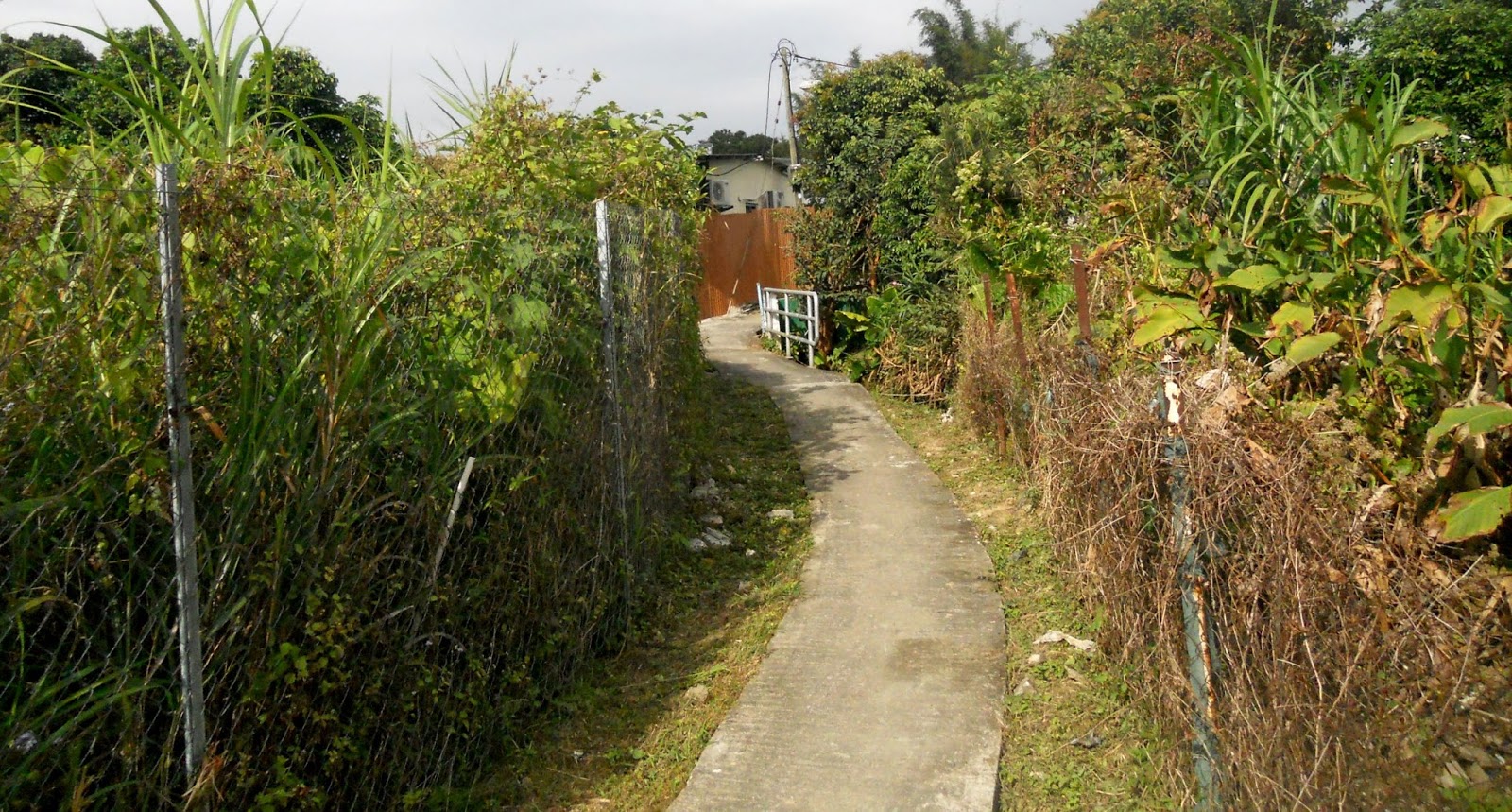
Merely to avoid cycling on the road, I’d been following a narrow path on the south side of Tsiu Keng Road, the second of the two roads referred to above, for quite a while, but it was only what I would class as ‘routine’. However, there was a junction with another path halfway along. I’d previously glanced along it and decided that it looked like a dead end. You’d think I’d know better by now, but I thought that I’d better check it out after the success of my ‘major upgrade’. Everything seemed very straightforward at first, but what had started as an easy concrete path soon turned into a narrow dirt path between two fences. Then I reached the river, and it looked as though I could go no further, but on closer inspection I found a narrow concrete path, again between two fences. The surface of this path is convex, which makes some of the tight turns quite tricky, but I eventually reached the river again at ‘the iron bridge’. This isn’t as nerve-racking as it might appear in the photograph below, and the path continues across farmland until it reaches the main Fan Kam Road close to its junction with Tsiu Keng Road.

The following map shows the section of path between the main road and the river. The entire path, which is about 900 metres in length, can now be done in both directions.


The numbers on the map refer to the positions from where the five photographs in the following sequence were taken while following the path in the opposite direction to that described. The continuation of the path can clearly be seen sweeping across to the left in the first photo. In the fifth photo, the right-hand path is the correct one. The left-hand option is a dead end.


And this is a photo of Paula on the iron bridge, taken from the same position as the previous photo:


The next two photos were taken where the route returns to the river, and the final three where the path finally becomes easy to follow. The path west of the river shown on the above map is not accurately located:


*  *  *

It goes without saying that I was delighted to have found such a long, exciting addition to the long and winding road, but I also had something else to check out once I’d ridden along the new path described above in both directions. Next to the start of the alleyway that leads to the spiral ramp, there is another path, less obvious, that drops down to the right and out of sight. I quickly discovered that after about 10–12 metres it reaches a T-junction. I intended to find out eventually where both directions would lead, but I initially turned left here, and after many twists and turns I ended up in the large village of Hang Tau. I continued through the village until I found an alleyway that led to a bridge across the river:


This photo was taken from an early section of the original route, which then continued past the entrance to the footbridge. However, it was obvious that reversing the route I’d just followed would be a major improvement, although it would have been very difficult to find the start of the path had I begun my initial exploration from this end. The first three photos were taken before the path leaves the village:


Once out in the open, the path is easy to follow:


After passing the small group of squatter houses seen in the last photo, the path crosses a bridge over a major drainage channel. The following photograph, taken from the bridge, shows a Drainage Services access path on the right of the channel, which is where the route goes next:


At the end of this access path, the route crosses the channel via the bridge seen in the distance in the next photo:


…and continues up yet another narrow path:


…eventually reaching the T-junction referred to above:


*  *  *

Having added two new narrow paths to the route in a single day, I found myself lying awake on the next few nights trying to figure out the optimum way of linking everything together. Clearly, the second path I’ve described would have to come at the beginning, and although it would be possible then to continue with the original sequence of three paths, this would have involved a long (and boring) road sequence.

It made more sense to start with the third of the three original paths, but then if the ‘rule’ about not returning immediately along the same path were to be adhered to, then a simple topological analysis shows that it would be impossible to leave the return along this third path to the end, yet that would be necessary if I wanted to include the spiral ramp in the route. I solved the problem by including a traverse of the ‘iron bridge path’ between out and back traverses of the second original path. I included the traverse of the iron bridge path in the opposite direction immediately following the outward traverse of the third original path.

I mentioned earlier that narrow paths present different challenges depending on the direction of travel, but there is one section where I’ve decided to waive this procedure. The top of the path shown in the previous photo leads immediately to the spiral ramp, so I’ve included this extreme test of handling skill in the revised route at this early point in the overall journey. However, the first of the new additions to the main route, which I described earlier, also included the spiral ramp, although it originally reached the top of this slope via a different pathway. “Why not do the ramp twice?” I thought. And in the process of trying to rationalize the various options here, I found that I could reach the T-junction from the opposite direction simply by taking a longer approach route:


What’s not to like? I’ve included three photos of the T-junction because, although the slope is not excessive at this point, the turn, from both directions, will catch you out if you are not in a sufficiently low gear, but especially if you are coming from the direction indicated by this final photo. Then, to finish, the second path described above, in reverse, completes the route.

I asked Paula her opinion of the new additions to the route. Her verdict? “Hard work” and “technical”. When I took my Aussie friend Bernie around the original route last Easter, he rated it as “thrilling”. I’ve told him that he will need to do it again the next time he’s in town after I’d discovered the spiral ramp, but I haven’t yet told him about the other new additions. I wonder what he’ll have to say.

Sunday 15 January 2017

a kaleidoscope of colour

When I posted The Long Way Home last November, I neglected to mention that there are two routes I could have followed: one that takes a wide swing to the north—the one that I described—and one that takes an equally wide swing to the south. It’s rare for me to follow this latter route on foot, because at some stage I will have to cross a busy main road, but it’s probably true to say that this option is more interesting.

One point of interest, which I wrote about in An Unhappy Garden, is Happy Garden, an abandoned garden with an ornate entrance that includes steps and a masonry gateway. At that time, this entrance was in a severely dilapidated condition, but in 2015, Drainage Services constructed a nullah* alongside the road that passes in front of the steps, during which the entire entrance was ‘restored’. The nullah, once completed, was covered with narrow concrete beams, which now function as a discrete ‘sidewalk’ alongside that stretch of road.

I cycle along this section of road quite frequently, but I hadn’t walked along it since the nullah had been completed—until yesterday, when rain and low temperatures combined to make my normal bike ride on a Saturday morning with Paula a distinctly unattractive proposition. We saw nothing unusual until we reached the sidewalk section, but at this point I was staggered to find the concrete beams awash with bright colours. The oil that was creating these colourful patterns could not have come from a motor vehicle, because there is a barrier between the road and the ‘sidewalk’, but the entire 30-metre section was covered with a thin veneer of something that was refracting the light. I wonder if it originated on the hillside above.

Anyway, as was previously the case with Colour Field Analysis and Christmas Flowers, in which all the images were collected on a single day, I’ve decided to post a selection of the photos I took yesterday. I’ve assigned purely neutral titles, but if anyone wants to suggest titles for any image in this collection, please feel free to do so. I would also welcome opinions on which of these images you find most appealing. My own favourite is #6.

* A nullah (one of a very small number of words that I’ve only ever encountered in Hong Kong), is what would be called a culvert in the UK.

kaleidoscope #1

kaleidoscope #2

kaleidoscope #3

kaleidoscope #4

kaleidoscope #5

kaleidoscope #6

kaleidoscope #7

kaleidoscope #8

kaleidoscope #9

kaleidoscope #10

kaleidoscope #11

kaleidoscope #12