What do the following have in common?No! It isn’t quite that easy. If you identify the correct criterion, you will see that it isn’t possible to add any more letters to the list.
D ● J ● Q ● W
Monday, 31 December 2018
an elementary puzzle
I used to post puzzles on New Year’s Eve that were designed to give you a hangover without the alcohol, but nobody seems able to solve my more difficult problems, so here’s another easy one instead:
Friday, 28 December 2018
cycling action photos #2
Since posting Cycling Action Photos in May last year, I’ve continued to add new images to the collection. Few can be regarded as ‘exciting’ in themselves, but taken overall they do provide an accurate sense of what Paula and I spend our time doing.
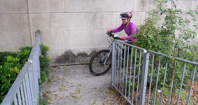
The first three photos show Paula on a then newly discovered addition to the long and winding road that I described in Room for Improvement. The slope isn’t excessive, but you will need to be in bottom gear at the start because the turn is more awkward than it appears:


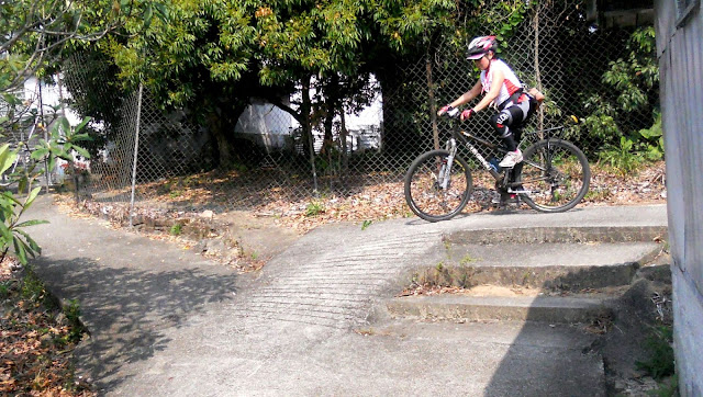
The next two photos, taken on the same day from the same vantage point, show the only remotely difficult part of ping kong ping pong. This ramp is almost as steep as the spiral ramp, but as you can see, there is plenty of wobble room, so it is much easier:


The next photo shows an addition to the final frontier that I described in Is That It? This path is no more than 45cm wide, and the drop off the inside of the curve is similar to that off the outside, so the secret is to go fast(ish) to avoid wobbling.

When I originally established journey to the west at the beginning of 2013, after crossing the expressway, I followed a path around an upmarket, low-rise housing complex. These photos show Paula on the exit ramp from that path onto Kwu Tung Road:

The ramp is easy, but the turn is slightly tricky.
The continuation of journey to the west on the other side of Kwu Tung Road involves yet another narrow path around another low-rise housing complex, and the next two photos show a section of the path just before it reaches the witch’s house and the official start of the long and winding road:


This section isn’t difficult either—as long as you’re in a suitably low gear.
Before moving on to images of sections that were discovered last winter, here is a photo of Paula on the path through a squatter area that we use every time we want to get from our local river to Sheung Shui and thence westwards:

There are no difficulties anywhere along this path, but there is a noticeable drop off both sides at this point.
When I came back to Hong Kong in October 2017, following the serendipitous discovery of a narrow path connecting it to Hok Tau Road, one of the first areas that I wanted to explore was the villages south of Sha Tau Kok Road, east of that road’s junction with Ping Che Road. This exploration turned up some interesting amusements, including this short ramp in the village of Ma Mei Ha:


If you think that this looks easy, take a look at the same ramp from below:

There is absolutely no wobble room!
By contrast, the following photos, showing part of serendipity #2, may look tricky, but this section is easy if your brakes are reliable:

The remaining images are all video stills. The first set shows the iron bridge path, one of my favourite sections of the long and winding road:


The next video still shows the last narrow path on the long and winding road:

There is nothing technically difficult here, but as I’ve commented previously, hills on narrow paths always seem like hard work compared with the same hill on an open road. And this hill certainly gets harder further up.
I was discussing swiss roll with Paula recently, and we agreed that it’s much harder than the spiral ramp:


Finally, oriental garden is an as yet undescribed alleyway linking Kam Hang Road with an unnamed dead-end road running parallel to the expressway. A few weeks ago, I had occasion to follow it backwards, and as a result, I found an even better way through. I simply had to show Paula. We had just invested in a second mounting bracket for the camera, and this is what Paula captured:

It is as steep as it looks! And the approach is at 90 degrees to the ramp, so you can’t see what’s coming up. I succeeded on my first attempt because I saw the yellow handrail and interpreted it as a warning, but I neglected to warn Paula in advance, and she stalled at this point.
Unfortunately, I’ve since been crocked with a mystery injury, so we haven’t yet been back, but I have no doubt that my wife will be able to handle this now that she knows what to expect.
The first three photos show Paula on a then newly discovered addition to the long and winding road that I described in Room for Improvement. The slope isn’t excessive, but you will need to be in bottom gear at the start because the turn is more awkward than it appears:


The next two photos, taken on the same day from the same vantage point, show the only remotely difficult part of ping kong ping pong. This ramp is almost as steep as the spiral ramp, but as you can see, there is plenty of wobble room, so it is much easier:


The next photo shows an addition to the final frontier that I described in Is That It? This path is no more than 45cm wide, and the drop off the inside of the curve is similar to that off the outside, so the secret is to go fast(ish) to avoid wobbling.

When I originally established journey to the west at the beginning of 2013, after crossing the expressway, I followed a path around an upmarket, low-rise housing complex. These photos show Paula on the exit ramp from that path onto Kwu Tung Road:


The ramp is easy, but the turn is slightly tricky.
The continuation of journey to the west on the other side of Kwu Tung Road involves yet another narrow path around another low-rise housing complex, and the next two photos show a section of the path just before it reaches the witch’s house and the official start of the long and winding road:


This section isn’t difficult either—as long as you’re in a suitably low gear.
Before moving on to images of sections that were discovered last winter, here is a photo of Paula on the path through a squatter area that we use every time we want to get from our local river to Sheung Shui and thence westwards:

There are no difficulties anywhere along this path, but there is a noticeable drop off both sides at this point.
When I came back to Hong Kong in October 2017, following the serendipitous discovery of a narrow path connecting it to Hok Tau Road, one of the first areas that I wanted to explore was the villages south of Sha Tau Kok Road, east of that road’s junction with Ping Che Road. This exploration turned up some interesting amusements, including this short ramp in the village of Ma Mei Ha:


If you think that this looks easy, take a look at the same ramp from below:

There is absolutely no wobble room!
By contrast, the following photos, showing part of serendipity #2, may look tricky, but this section is easy if your brakes are reliable:


The remaining images are all video stills. The first set shows the iron bridge path, one of my favourite sections of the long and winding road:


The next video still shows the last narrow path on the long and winding road:

There is nothing technically difficult here, but as I’ve commented previously, hills on narrow paths always seem like hard work compared with the same hill on an open road. And this hill certainly gets harder further up.
I was discussing swiss roll with Paula recently, and we agreed that it’s much harder than the spiral ramp:


Finally, oriental garden is an as yet undescribed alleyway linking Kam Hang Road with an unnamed dead-end road running parallel to the expressway. A few weeks ago, I had occasion to follow it backwards, and as a result, I found an even better way through. I simply had to show Paula. We had just invested in a second mounting bracket for the camera, and this is what Paula captured:

It is as steep as it looks! And the approach is at 90 degrees to the ramp, so you can’t see what’s coming up. I succeeded on my first attempt because I saw the yellow handrail and interpreted it as a warning, but I neglected to warn Paula in advance, and she stalled at this point.
Unfortunately, I’ve since been crocked with a mystery injury, so we haven’t yet been back, but I have no doubt that my wife will be able to handle this now that she knows what to expect.
Monday, 24 December 2018
then and now
It isn’t often that I capture an image that reveals a radical transformation of the location where the image was taken compared with an earlier image, but I’ve come up with two recently where the contrast is quite startling.
A few weeks ago, I was cycling along a quiet road in my neighbourhood when I caught up with a concrete mixer truck that was being trailed by a caravan of four or five cars. Like most of the back roads in the area, it was single-track, so the cars wouldn’t have been able to overtake the truck—there are few designated passing places—and the result of any motor vehicle coming in the opposite direction would have been total chaos.
No problem, I thought. I can take panty park path and thereby get ahead. This path is a narrow alleyway through a squatter area on a hillside, and following it is shorter than following the road, but since describing it, I haven’t done it very often because it doesn’t link to any of my established bike rides:

And I was in for a surprise:

I assume that this part of the path was damaged by heavy rain during the destructive passage of Typhoon Mangkhut back in September, and it looks as though a chain-link fence is being built to protect what is probably a big drop off the side of the path. I don’t usually mind cycling close to such a drop, but not when the surface I’m riding on is sloping towards that drop. So I turned back. And guess what: the predicted chaos did come to pass, so I simply sneaked through the gaps between the participating vehicles.
The second pair of images definitely reflects typhoon damage. Both are video stills of a section of the iron bridge path, which is part of the long and winding road:


The first video, which features Paula, was shot earlier this year, while the second image shows me in front and is taken from a video shot a couple of weeks ago. Given that bamboo has very shallow roots, I wonder why the second clump survived the wind when the larger one did not. Size is clearly not an advantage in all circumstances.
Sunday, 16 December 2018
safety first
On my first day back in Hong Kong last month, Paula and I did what we always do—go for a bike ride. Since 2013, that has meant the frontier road, which has no serious hills and presents no major technical difficulties. On this occasion though, as we approached the end of the road:

…we were stopped by two policemen. I hasten to add that we were not transgressing any traffic regulations; nor were we riding dangerously. They just wanted to give us a safety leaflet and take a photo with us, presumably to show their superiors how many cyclists they had passed the safety message on to.
The leaflet contained advice in twelve bullet points, in Chinese and English. Most were merely common sense, the kind of thing that any switched-on cyclist would do without being told, but there were some that I feel bound to comment on:
It is a common conceit that once you learn how to ride a bike, you never forget, but this applies only to staying upright while moving forward. So what happens when you want to stop? It is very common here to see a cyclist’s feet come off the pedals to scrape along the ground, which implies that they haven’t learned how to use their brakes. I would amend this point as follows:
Those were my comments on the advice, but there were also some glaring omissions. I would add the following:
And there are two contexts in which local cyclists should use their bells, but don’t. The first is when overtaking pedestrians or other cyclists on a shared section that has plenty of room for you to do so. Why would you need to do that? Because the pedestrian or cyclist may change direction suddenly if they are unaware that a bike is approaching from behind. Failing to sound your bell in the second context is a particularly egregious error. You must ring it when approaching a blind bend or corner, in case there is someone you can’t see around that corner.
While I applaud the efforts of the Road Safety Council—the producers of this leaflet—to promote safer cycling, I do wonder how many experienced cyclists it consulted before issuing its guidelines. And I also wonder how many people will see a copy of its leaflet, because the way many local, weekend and recreational cyclists ride suggests a complete ignorance of safe practices.
footnote
For definitions of the terms local, weekend and recreational cyclist, see Cycling in Hong Kong.

…we were stopped by two policemen. I hasten to add that we were not transgressing any traffic regulations; nor were we riding dangerously. They just wanted to give us a safety leaflet and take a photo with us, presumably to show their superiors how many cyclists they had passed the safety message on to.
The leaflet contained advice in twelve bullet points, in Chinese and English. Most were merely common sense, the kind of thing that any switched-on cyclist would do without being told, but there were some that I feel bound to comment on:
Wear a helmet, pads and other protective gear.I certainly don’t advocate that wearing a helmet be made compulsory, as is the case in Australia and New Zealand, but in Hong Kong the cyclists that are most likely not to be seen wearing a helmet are also the least competent. However, I was utterly astounded to discover that the leaflet recommended the wearing of knee and elbow pads (I haven’t misunderstood this point, because there are photos of the kind of pads often used by skateboarders). This might be fine on a skateboard, but I would have thought that the alternate bending and straightening of one’s knees when cycling would make wearing pads extremely uncomfortable.
…obey traffic rules, traffic signs, road markings and traffic light signals.I would like to emphasize this point, because in both the UK and Hong Kong, there are far too many cyclists who appear to believe that none of this applies to them. It is also the case that the majority of riders using dedicated cycle tracks in the New Territories appear not to be aware of the meaning of double white lines and give way markings at junctions, probably because nobody told them!
Ride in single file along the left side of the road near the kerb….Large groups of cyclists are invariably a nuisance, mainly because they do not follow this advice and are likely to spread out across the entire road if there isn’t much traffic, with individuals showing no awareness that the group, as a group, constitutes a serious traffic hazard. However, I did see a group of about forty a while ago near the frontier east of Ta Kwu Ling who followed this rule impeccably. Kudos to them.
Control your speed when riding on an inclined surface and allow room for braking.When I wrote about the sign instructing cyclists to get off their bikes and push a year ago, I wasn’t aware that a young woman had been killed after losing control of her bike on this particular hill. However, I’m not surprised that someone would lose their life in such a situation, because far too many local and weekend cyclists have no idea how to stop!
It is a common conceit that once you learn how to ride a bike, you never forget, but this applies only to staying upright while moving forward. So what happens when you want to stop? It is very common here to see a cyclist’s feet come off the pedals to scrape along the ground, which implies that they haven’t learned how to use their brakes. I would amend this point as follows:
Be aware of your speed when riding downhill and learn how to use your brakes.You will notice that I’ve amended the first part of this point too, because I do like to see how fast I can go on downhill sections, provided that there is a safe runout at the bottom. A good example of this is the switchback, part of the final frontier.
When passing, turning or stopping, always look around and make hand signals to alert other road users of [sic] your intentions.I had to suppress a chuckle here, because the only cyclist whom I’ve ever seen using hand signals is Paula, and she picked up the habit from me. To me, letting other people know what you’re about to do is simple common sense.
* * *
Those were my comments on the advice, but there were also some glaring omissions. I would add the following:
Never listen to music while cycling.A few days ago, I was cycling along a wide and relatively quiet road in Sheung Shui on my way out west. I was approaching a junction to the left, which I would pass, when I heard a car behind me. The sound made me suspect that the driver was slowing down to turn left, so although I didn’t change my own speed, I was aware that this might happen. I was right. The car came alongside and immediately started its turn. It was almost as if I wasn’t there. Had I not suspected that this might happen, this clown would have taken me out. And I wouldn’t even have been aware of his/her existence if I’d been listening to music. I depend on my sense of hearing when cycling. So should every cyclist.
Use your bell correctly.This may seem like a statement of the obvious. However, weekend cyclists seem to think that their bike’s bell is some kind of esoteric communication device. That was certainly my impression when I last ventured onto the cycle track between Shatin and Taipo on a weekend. I would ring my bell to let a group of weekenders know that I was about to overtake them, and they would all ring their own bells in response. Perhaps things have changed, because I keep away from busy areas at weekends nowadays.
And there are two contexts in which local cyclists should use their bells, but don’t. The first is when overtaking pedestrians or other cyclists on a shared section that has plenty of room for you to do so. Why would you need to do that? Because the pedestrian or cyclist may change direction suddenly if they are unaware that a bike is approaching from behind. Failing to sound your bell in the second context is a particularly egregious error. You must ring it when approaching a blind bend or corner, in case there is someone you can’t see around that corner.
* * *
While I applaud the efforts of the Road Safety Council—the producers of this leaflet—to promote safer cycling, I do wonder how many experienced cyclists it consulted before issuing its guidelines. And I also wonder how many people will see a copy of its leaflet, because the way many local, weekend and recreational cyclists ride suggests a complete ignorance of safe practices.
footnote
For definitions of the terms local, weekend and recreational cyclist, see Cycling in Hong Kong.
Tuesday, 11 December 2018
on the money
My last post described a not entirely new addition to our regular Saturday bike ride, and this post is an account of another segment, the existence of which I already knew about, that we’ve added to the ride. I discovered the connection between Hang Tau Road and Kam Tsin Road, in the area between the Sheung Yue River and Fanling golf course, last winter, but I’d only ever ridden down the crucial section. However, I worked out that if it turned out to be possible to ride up that section, then instead of taking the shortest and most obvious route from Kwu Tung Road to the start of ‘oriental garden’, we could add about 1.5 kilometres to the ride by following Kam Tsin Road, then doubling back along Kam Hang Road to the narrow alleyway we call ‘oriental garden’.
The following images are stills from a video that I shot last week, with comments where appropriate. The start looks (and is) straightforward:

However, the alleyway narrows and begins to climb:


The route turns to the left beyond the building:

…and starts to climb again:


There is a sharp (and awkward) turn to the left in the distance:

A closer look at that turn:

It isn’t obvious from the following image, but there is a drain on the right of the path (you can see its continuation in the previous image), so if you’re careless here, you are certain to come off your bike:

The angle eases off before the path joins an unnamed and presumably unregistered road:

The rest of the route is straightforward, although as you can see, the condition of the road surface is poor:


The car in the distance marks the top of the hill:

…and is followed by a fast downhill section through an obvious industrial area:

Kam Tsin Road, which is soon reached, is not a through road, so it carries relatively little traffic:


I asked Paula what name we should give to this connection. She didn’t notice that we had been cycling along Kam Tsin Road, but where this road eventually joins Kam Hang Road, she did spot that we were passing through the outskirts of the village of Kam Tsin. And kam tsin is Cantonese for ‘gold money’, so the name would have to be cash-related. This diversion serves its purpose admirably, so it’s on the money!
Thursday, 6 December 2018
easter island
In concluding my recent overview of our regular Saturday bike ride, I knew that I was tempting fate when I wrote the following:
What we now call ‘the frontier road’ was part of the so-called ‘frontier closed area’ until the beginning of 2013, which meant that ordinary members of the public, such as Paula and I, would have needed a permit to enter. It was an instant hit with us: the scenery is delightful; and there is almost no traffic (this remains the case). However, there are two drawbacks: it is too short to do by itself; and having reached the end of the road, it is then necessary to go back the way you’ve just come.
To tackle the second of these objections, I tried to find an alternative way to return to our starting point (or to reach the end of the frontier road by an alternative route, then follow the frontier road backwards). I succeeded, but it was never a popular option because it involved an extended portage section, and I haven’t cycled that way for quite a few years.
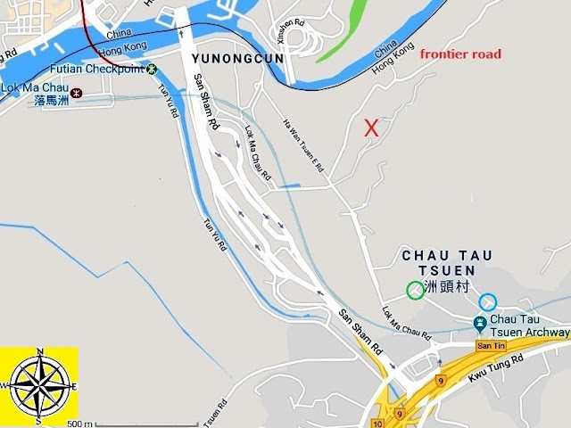
However, because I wanted to see if I could add anything more to the ride, I decided to take a closer look at that original alternative last week. You will see from the map that it isn’t possible to travel any further west after following the frontier road because there is a major crossing point into China. It isn’t merely a case of a casual cyclist being afraid to brave the traffic here, because both sides of the roads leading to the crossing are marked by impenetrable fences, and to circumvent this obstacle it is necessary to travel south to the extremely busy roads marked on the map.
I cycled through the village of Chau Tau on the aforementioned alternative, although I doubt that I would have noted the name (tsuen merely means ‘village’ and is not part of the formal name), so I wondered whether a tour around that village might be a feasible option. There is one slight problem. Lok Ma Chau Road does not carry a lot of traffic, but what there is (taxis and minibuses mainly) travels at high speed, so it is safer to ride on the pavement (sidewalk), something that I’m usually reluctant to do.
However, you are as likely to encounter a motor vehicle here as a pedestrian, and the distance is very short. This sequence of photos shows what is involved:


After about 450 metres, a side road is reached that leads into the village:

Unless you are familiar with rural Hong Kong, or with Chinese culture, you probably won’t know what this photo shows. It is an ossuary. Each of these large ceramic jars contains a human skeleton. I’m not going to go into how a skeleton can be fitted into such a small jar, because I don’t know, and to be honest, I’m not interested in finding out.
The next photo shows the first houses in the village:

Surprisingly, though, only a tiny part of the village is accessible to motor vehicles here, although there is a clear path for pedestrians and bikes:


It even begins to look like countryside for a short distance:


The cars in the second photo must negotiate an extremely devious route to reach this position, while the houses in the next two photos are not directly accessible by car:


The path eventually widens to become a narrow road:

An interesting feature of the next photo is the brown plaque next to the gate on the left. The three large characters proclaim the name of the premises (the leftmost character is universally known as ‘double happiness’), while the smaller characters translate as ‘Chau Tau village no. 278’. You probably think that there is nothing out of the ordinary in this, until I point out that village houses are usually numbered in the order they were built rather than in a scheme based on their relative positions—a nightmare for a new postman, or for anyone else trying to deliver items to a particular house!

The continuation of the road in the next photo is in fact the only way into the village for motor vehicles. This junction is marked by the blue circle on the map:

The turn to the right, Chau Tau South Road, is a one-way road:

I never cycled along this road when I passed through the village in the past, which is probably why I never spotted this:

Archways like this are not common, and this may be the most impressive I’ve seen. They usually mark the entrance to a village, but the road running beneath here is a dead end, except for pedestrians. And you shouldn’t make the mistake of thinking that this is some kind of historical monument. It was built in 2006, according to an inscription on one of the side pillars, and it commemorates auspicious events in the village’s history.
The bas relief mouldings on the crossbeams are definitely worth a closer look:

The top panel features two phoenixes, while the bottom panel has two dragons facing off against each other. The central panel appears to be a general scene of nature.
The reverse side of the crossbeams has a similar set of mouldings:

The main difference in subject matter is that the middle panel shows cranes in a lotus pond. I can’t provide an explanation for the pagoda between the two dragons in the bottom panel.
Unsurprisingly, the archway is guarded by two lions, which I’ve placed together in the following image to emphasize their ferocity and intimidating appearance:

Something that I’ve never understood is the significance of lions in Chinese culture. The range of Asiatic lions never extended so far east in historical times. And there’s an even more puzzling anomaly. Chinese lions ignore the sexual dimorphism of real lions: both the animals in my photo have manes, yet one is female (and one is male). Can you tell which is which?
Chau Tau, like many isolated villages, had its own fish pond (although it is no longer used for that purpose):

The red ‘flowers’ are bougainvillea.
The final photo shows the approach to the junction marked on the map by a green circle. The next road, Chau Tau West Road, is also one-way and thus doesn’t provide access to the village from Lok Ma Chau Road:

However, one can turn left here and follow Lok Ma Chau Road back to the frontier road.
Incidentally, the red X marks the correct location of the village of Lok Ma Chau, which is also the name of a station on the MTR network (see map) and a border crossing. Google locates the village about 150 metres south of its correct position, but that is merely Lok Ma Chau police station. Lok Ma Chau police operational base is several kilometres to the east along the frontier road.
Confused? You will be when I explain the title of this post. ‘Chau Tau’ is Cantonese for ‘island head(s)’, and of course I thought immediately of the island that is known for its stone heads. Sorry I mentioned it!
I don’t expect to be able to add anything else to this ride, but I’ve thought that in the past and been proved wrong, so who knows what the coming winter will bring….It hasn’t taken me long to find something new to add. Well, ‘something new’ may be overstating the case, as I will endeavour to explain.
What we now call ‘the frontier road’ was part of the so-called ‘frontier closed area’ until the beginning of 2013, which meant that ordinary members of the public, such as Paula and I, would have needed a permit to enter. It was an instant hit with us: the scenery is delightful; and there is almost no traffic (this remains the case). However, there are two drawbacks: it is too short to do by itself; and having reached the end of the road, it is then necessary to go back the way you’ve just come.
To tackle the second of these objections, I tried to find an alternative way to return to our starting point (or to reach the end of the frontier road by an alternative route, then follow the frontier road backwards). I succeeded, but it was never a popular option because it involved an extended portage section, and I haven’t cycled that way for quite a few years.
However, because I wanted to see if I could add anything more to the ride, I decided to take a closer look at that original alternative last week. You will see from the map that it isn’t possible to travel any further west after following the frontier road because there is a major crossing point into China. It isn’t merely a case of a casual cyclist being afraid to brave the traffic here, because both sides of the roads leading to the crossing are marked by impenetrable fences, and to circumvent this obstacle it is necessary to travel south to the extremely busy roads marked on the map.

I cycled through the village of Chau Tau on the aforementioned alternative, although I doubt that I would have noted the name (tsuen merely means ‘village’ and is not part of the formal name), so I wondered whether a tour around that village might be a feasible option. There is one slight problem. Lok Ma Chau Road does not carry a lot of traffic, but what there is (taxis and minibuses mainly) travels at high speed, so it is safer to ride on the pavement (sidewalk), something that I’m usually reluctant to do.
However, you are as likely to encounter a motor vehicle here as a pedestrian, and the distance is very short. This sequence of photos shows what is involved:


After about 450 metres, a side road is reached that leads into the village:

Unless you are familiar with rural Hong Kong, or with Chinese culture, you probably won’t know what this photo shows. It is an ossuary. Each of these large ceramic jars contains a human skeleton. I’m not going to go into how a skeleton can be fitted into such a small jar, because I don’t know, and to be honest, I’m not interested in finding out.
The next photo shows the first houses in the village:

Surprisingly, though, only a tiny part of the village is accessible to motor vehicles here, although there is a clear path for pedestrians and bikes:


It even begins to look like countryside for a short distance:


The cars in the second photo must negotiate an extremely devious route to reach this position, while the houses in the next two photos are not directly accessible by car:


The path eventually widens to become a narrow road:

An interesting feature of the next photo is the brown plaque next to the gate on the left. The three large characters proclaim the name of the premises (the leftmost character is universally known as ‘double happiness’), while the smaller characters translate as ‘Chau Tau village no. 278’. You probably think that there is nothing out of the ordinary in this, until I point out that village houses are usually numbered in the order they were built rather than in a scheme based on their relative positions—a nightmare for a new postman, or for anyone else trying to deliver items to a particular house!

The continuation of the road in the next photo is in fact the only way into the village for motor vehicles. This junction is marked by the blue circle on the map:

The turn to the right, Chau Tau South Road, is a one-way road:

I never cycled along this road when I passed through the village in the past, which is probably why I never spotted this:

Archways like this are not common, and this may be the most impressive I’ve seen. They usually mark the entrance to a village, but the road running beneath here is a dead end, except for pedestrians. And you shouldn’t make the mistake of thinking that this is some kind of historical monument. It was built in 2006, according to an inscription on one of the side pillars, and it commemorates auspicious events in the village’s history.
The bas relief mouldings on the crossbeams are definitely worth a closer look:

The top panel features two phoenixes, while the bottom panel has two dragons facing off against each other. The central panel appears to be a general scene of nature.
The reverse side of the crossbeams has a similar set of mouldings:

The main difference in subject matter is that the middle panel shows cranes in a lotus pond. I can’t provide an explanation for the pagoda between the two dragons in the bottom panel.
Unsurprisingly, the archway is guarded by two lions, which I’ve placed together in the following image to emphasize their ferocity and intimidating appearance:

Something that I’ve never understood is the significance of lions in Chinese culture. The range of Asiatic lions never extended so far east in historical times. And there’s an even more puzzling anomaly. Chinese lions ignore the sexual dimorphism of real lions: both the animals in my photo have manes, yet one is female (and one is male). Can you tell which is which?
Chau Tau, like many isolated villages, had its own fish pond (although it is no longer used for that purpose):

The red ‘flowers’ are bougainvillea.
The final photo shows the approach to the junction marked on the map by a green circle. The next road, Chau Tau West Road, is also one-way and thus doesn’t provide access to the village from Lok Ma Chau Road:

However, one can turn left here and follow Lok Ma Chau Road back to the frontier road.
Incidentally, the red X marks the correct location of the village of Lok Ma Chau, which is also the name of a station on the MTR network (see map) and a border crossing. Google locates the village about 150 metres south of its correct position, but that is merely Lok Ma Chau police station. Lok Ma Chau police operational base is several kilometres to the east along the frontier road.
Confused? You will be when I explain the title of this post. ‘Chau Tau’ is Cantonese for ‘island head(s)’, and of course I thought immediately of the island that is known for its stone heads. Sorry I mentioned it!
Subscribe to:
Posts (Atom)

