Sunday, 1 October 2017

photographic abstraction #24

My latest collection of abstract photographs features the usual mixture of old and new motifs. Further details follow each image.

bloody hell

jigsaw

Jigsaw makes use of a motif that I’ve employed previously on Blood, Sweat and Tears (Photographic Abstraction #16), Surface of the Moon (#18) and Sheep May Safely Graze (#19). If you compare these four images, you will see that this is probably the most versatile motif I use.

leapfrog

Leapfrog is the only photo in this collection to feature a completely new motif, and I’d be surprised if anyone can identify what it is actually a photograph of. I know, I’ve written that before and been proved wrong, so see if you can work it out.

naff giraffe

Naff Giraffe comes from the same source as Distribution in Photographic Abstraction #23. For the origin of these images, I refer you to the photo of the staithe featured in Photographic Highlights 2016–17. There are steps leading down to the water at each end of the staithe, and the side walls have the most amazing patterns, which I believe have been created by lichen.

phantasmagoria

I no longer recall where I took this photo, but I’m fairly sure that it’s an image of the staining on the exterior walls of a squatter hut.

shattered dreams

Shattered Dreams derives from the same source as The Crystal Maze (Photographic Abstraction #20). Some time ago, Paula and I came across a discarded car windscreen by the side of the road, and these two images are the result.

Friday, 15 September 2017

connections?

I’ve got a little list…
WS Gilbert, The Mikado.
I don’t usually post puzzles at this time, but this is not intended to be a serious attempt to bamboozle my readers. Below are eight photos of Penrith landmarks, all of which are identified and described. The order in which they appear is not significant. So what do these landmarks have in common?

The first two photos are of gateposts:

Gateposts: Corney House, Stricklandgate

Gateposts: Mansion House, Friargate

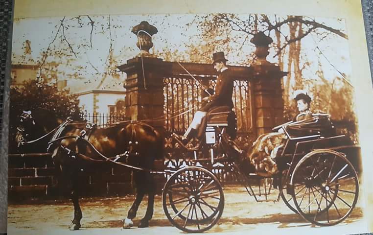
The second pair of gateposts were once topped by carved stone urns, as the following photograph, taken circa 1910, shows. It was originally captioned ‘The doctor’s wife’, implying that there was only one doctor in town at the time. This seems unlikely:


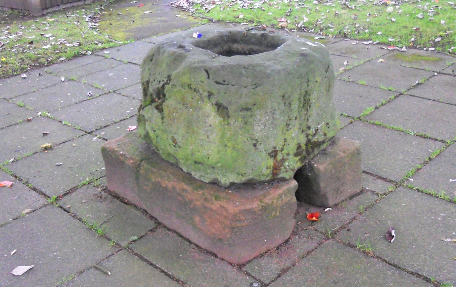
During the Middle Ages, Penrith was, like most small towns, ravaged periodically by bubonic plague. This probably continued into the eighteenth century. Victims were buried in mass graves to the east of town, in areas that were built on in the nineteenth century. When the plague was raging, all financial transactions between townspeople and outsiders required the buyer to place coins into a stone basin filled with vinegar. Given that the transmission vector for bubonic plague is the fleas living on the backs of rats, I doubt the efficacy of such a procedure.

According to Wikipedia, Penrith’s ‘plague stone’ was fashioned in ‘whinstone’. I had always thought it to be sandstone, but on closer examination I found Wikipedia to be correct, which it often isn’t. ‘Whinstone’ is a quarryman’s term for dolerite, a chemical equivalent of basalt that forms shallow intrusions such as the Whin Sill, which underlies the mountain limestone of the North Pennines a dozen miles to the east of Penrith.

Plague stone

The next photo features more gateposts, these ones dating from the eighteenth century:

Gateposts: Dockray Hall, Great Dockray

The next two photos are of landmarks in the graveyard of the local parish church, St Andrew’s:

War memorial

Memorial to the men who built the L&CR

The war memorial, which takes the form of a Celtic cross, was constructed in 1919 to commemorate the Great War. The Lancaster and Carlisle Railway was completed in 1846 and was subsequently taken over by the London and North Western Railway.

There aren’t many of the traditional telephone boxes designed by Giles Gilbert Scott around nowadays, but here is one outside Penrith’s railway station:

K6-type phone box outside Penrith station

The final photo is of another war memorial, this time to remember the Boer War. It is otherwise known as ‘the Black Angel’ and once stood outside the town hall, but it was moved to Castle Park in the 1960s because it was being damaged by traffic fumes.

Black Angel, Castle Park

This list is incomplete.

Wednesday, 6 September 2017

backyard penrith

At the beginning of the nineteenth century, the population of my home town, Penrith, was around 3,800, and at that time, many residents lived in named yards in what is now considered the town centre. Many of these were accessible only through a single narrow passageway, which served a defensive function—Penrith is 30 miles from the Scottish border, and in earlier times it was a regular target of cross-border raiders (the sandstone hill that marks the town’s eastern perimeter is still called ‘the Beacon’, a reference to the practice of lighting fires on its summit to warn the townspeople that yet another raiding party was on its way).

Not many of these old yards still survive. In the 1950s, the local council embarked on a program of what it probably thought of as ‘slum clearance’. Several yards were flattened to build car parks. Some were rebuilt in a more modern style, while several others have had doors or gates placed across the entrance by their residents, so they are effectively off-limits to someone like me, who merely wants to record their existence. Nevertheless, I have been able to put together a collection of photos that I hope readers will find interesting.

Some yards are more like alleyways connecting two streets—there were once four such alleys between Middlegate and Bluebell Lane, but only Three Crowns Yard survives in anything close to its original state (the paving is relatively new, and I suspect that the building on the right in the first photo is new too):


This photo was taken from the end of Bluebell Lane looking down the yard, while the next photo shows the narrow passageway leading into Middlegate:


Notice the external staircase, which was a common feature in such yards.

Starting from the same place as Three Crowns Yard but leading to Cornmarket is White Hart Yard, which is wide enough to drive down, although nobody does nowadays:


The next photo was taken from the same point as the previous one looking back up the yard:


Griffin Yard leads off to the right close to the external staircase in the previous photo. The following photo shows the end of the yard, while the next image was taken looking back towards White Hart Yard:


The next photo was taken in what I originally identified as Sutton Yard, but thanks to diligent research by a friend, I can confirm that it is Ramsey Yard—it no longer has a nameplate over the entrance on Middlegate. It now has little of architectural interest apart from the passage leading to Middlegate, with its two date stones, neither of which, I suspect, belonged originally to the building of which they are now part (the buildings on both sides are modern):


In the same general area, there is an unnamed alleyway connecting Elm Terrace with the bottom of Castlegate. The external staircase in the following photograph is no longer in use, because the door to which it once led has been bricked up:


Across the road from the exit shown in the previous photo is Gloucester Yard. There is no name sign here, and the yard takes its name from the Gloucester Arms, one of four Grade I listed buildings in Penrith. Even though the present owners of this public house have reverted to the name it bore before it became a pub—Dockray Hall—the yard has kept the older name. The first photo is a view looking up the yard, while the second, taken from the same place, shows the entrance to the yard. The third photo was taken further up the hill looking down:


The final photo was taken in the now unnamed alleyway connecting Friargate with King Street and shows the passage leading to the latter:


All the photos here except those of Griffin Yard are of through routes. A few courtyard-style yards still survive, but they are now inaccessible.

Saturday, 26 August 2017

corporal clegg and friends

When I came to work at the Outward Bound School of Hong Kong in January 1974, I’d been attracted by the statement that ‘there are miles and miles of unexplored sea cliffs’. At the time, the school’s rock-climbing program was inadequate, so there was an urgent need to develop a more demanding alternative. The first location I visited was Fat Tong Point, in the far southeast of the New Territories (see map), which overlooks the narrow channel—Fat Tong Mun—between the mainland and Tung Lung Island.


In those days, it was common to see Chinese sailing junks negotiating Fat Tong Mun (mun is Cantonese for ‘door’), and I was most impressed by the levels of seamanship on display, because it was often necessary to perform complicated manoeuvres if the wind was blowing from an unfavourable direction. Incidentally, the logo of the Hong Kong Tourist Association is a sailing junk, but I haven’t seen a real one in Hong Kong harbour for decades. There is a motorized junk that plies the waters of the harbour, but this is merely an attraction for tourists, much like the rickshaws that used to line up next to the Star Ferry piers in Kowloon and on Hong Kong Island.

Fat Tong Point proved to be an ideal climbing venue for Outward Bound students, and we started using it a few months after I arrived in Hong Kong. We would go there with a group of twelve students for two days, camping overnight. On the first day, we tried to do as many easier climbs as we could on the section of cliff directly overlooking the narrowest part of the channel. The following photo is of a page from my records of the time. It shows four of these climbs, which range in length between 40 and 100 feet. The procedure was that I or my colleague for the exercise would lead a climb, and a student would then follow. They would then take the instructor’s place at the top and throw the rope down for the next student, a procedure that was repeated until everyone had done the climb.


The second day was a much tougher proposition. We identified four climbs graded VS (very severe, a respectable level of difficulty), and the challenge for the students was to climb all four. The next two photos show me leading the first of these climbs, Corporal Clegg. I had at the time a penchant for naming climbs after Pink Floyd songs, and this one is named after a track on the band’s second album, Saucerful of Secrets:
Corporal Clegg
Had a wooden leg.


Incidentally, the hardest climb at Fat Tong Point, Astronomy Domine, is named after a track on Pink Floyd’s first album, Piper at the Gates of Dawn. It would have been too dangerous for students to attempt.

The next climb is The Stoat, and the next two photos show my colleague David Lam leading the upper section. The lower section features a vicious finger-jamming crack that feels as if it’s trying to bite your fingers off, so I named it Weasel Crack. However, this climb continues up the easy section to the right of the climber, and I thought that the sloping ramp would make a better (i.e. harder) finish.


I don’t have any photos of the third climb, Right-Hand Wall, which was the only open wall climb among the four.

I named the fourth climb Cumbrian’s Chimney because I’m a native of Cumbria in the UK. Whenever I needed to get from the bottom to the top of a climb, I could go around the easy way, but I was always more likely to climb a route solo instead, as I’m seen doing in the next photo:


 Most of the climb succumbs to straightforward chimneying techniques, but in the photo, I’ve just reached the crux move. The chimney has closed to a narrow crack, so it is necessary to pull over an overhang. The conventional handholds are poor, but there are bomb-proof hand jams in the narrow crack.

I remember few specific incidents from the time we climbed here, but there is one that has remained lodged in my memory for more than 40 years. It was the second day, and as usual the target was for everyone to climb the four routes I’ve just described. A student came up to me:

“Sir! Sir!” he said. “I’m very tired.”

“How many climbs have you done James?” I asked.

“Two sir.”

“That means you have two more to do then!”

I don’t think this was the reply he wanted, but I never had any hesitation in taking advantage of aspects of Chinese culture—in this case that no Chinese will gainsay a teacher—in order to push students to step outside their personal comfort zones. And there is a postscript: James did climb the other two routes, and when we were being ferried back to school, the executive director, who was driving the school launch, asked who one of the students was. It was James, who now had a distinct swagger in his bearing.

We stopped going to Fat Tong Point for climbing in 1976, mainly because of the difficulty in extricating a party should there be a typhoon in the area. Now, the area has been taken over by the Clearwater Bay Golf and Country Club, and access to the climbing areas is much more difficult.