When I worked at the Hong Kong Outward Bound School between 1974 and 1984, I was frequently given copies of photographs that had been taken by students. Most of these were simply group photos that the students had posed for, but the occasional one was much more interesting. I’ve been looking through some of these photos since I came back to the UK last month, and I thought that relating the stories behind a few of them would be a worthwhile exercise:
When I applied to work at the Hong Kong Outward Bound School, I was attracted by two statements in the job description: that there were ‘miles and miles of unclimbed sea cliffs’, and the requirement that the successful candidate be able to lead climbs with a difficulty rating of very severe (VS), which, incidentally, was uncommon among Outward Bound instructors at the time. When I arrived, all the school’s rock-climbing activities took place on Spider Crag, a cluster of small outcrops within easy walking distance of the school.
The climbs were short and easy, and impossible to take seriously.
On the occasion when the above picture was taken, I’d been climbing up one of the routes that the students would be climbing later, without a rope or other encumbrances, when I decided to call for a top rope. This is usually a last-gasp emergency procedure, but my colleague clearly thought that I wasn’t being serious, which is why he dangled such a short length of rope down the rock face. What else could I do but grab it with my teeth?
It wasn’t long before I’d started exploring the unclimbed sea cliffs, and within three months we were taking groups to Fat Tong Point, a remote headland in the southeast of the New Territories, for two-day climbing expeditions. For several months thereafter, I wondered whether it might be possible to jump from the top of the cliff, across the descent gully, onto a flat-topped pinnacle about 4 metres away. The landing area was significantly less than 1 square metre, the take-off sloped towards the camera at about 30 degrees, and there was the small matter of a 15-metre drop onto some particularly nasty-looking sharp-edged boulders below the jump, so I was hesitant.
The remarkable aspect of this story is not that I did finally succeed in making the jump but that when I did, someone photographed me in the act!
After a first day climbing as many shorter and easier climbs as possible, the program for the second day was straightforward: four climbs, each graded VS and about 30 metres high. This photo is of one of these climbs, Cumbrian’s Chimney, which I named after my native county in the UK. The rope hanging down is for the benefit of the next student to climb up—the only reason I’m on the climb is that it’s a more enjoyable way to the top of the cliff than slogging up a crumbling hillside.
Chimneys are usually climbed by a technique known as back-and-footing, which the photo illustrates quite well. However, at the top the chimney closes to a narrow crack guarded by a pronounced overhang. It appears from my expression that I’m just about to make the crucial move: which involves stretching for a bomb-proof hand jam in the crack above my head. It’s easy enough if you know how to jam, but this is a technique that’s counterintuitive to most non-climbers, so I saw many improvised alternatives in the years that the school used this climbing venue.
While the first three photos were taken between 1974 and 1976, this one was taken after 1981. I know this because it is a shot of me crossing the eighth and final waterfall in the traverse of Luk Wu Ravine, which I didn’t discover until that year. It is straightforward under normal conditions, such as are depicted in the photo, but in flood conditions the traverse is potentially very dangerous and should be tackled only by people who know what they’re doing. Ropes are essential.
I used to attach a rope sling to the tree root above and right of my right hand to assist those students who weren’t tall enough to keep hold of the root and get their foot onto the big foothold where my right foot is in the photo. However, on a course that I ran for the American International School, several students decided to ignore my briefing. In turn, they grabbed the sling with both hands and launched gung-ho into space. At the end of the swing, they had no option but to let go and thus drop into the pool below the waterfall. I recall that I found it difficult to conceal my amusement.
Thursday, 13 June 2013
Friday, 24 May 2013
rainbow river
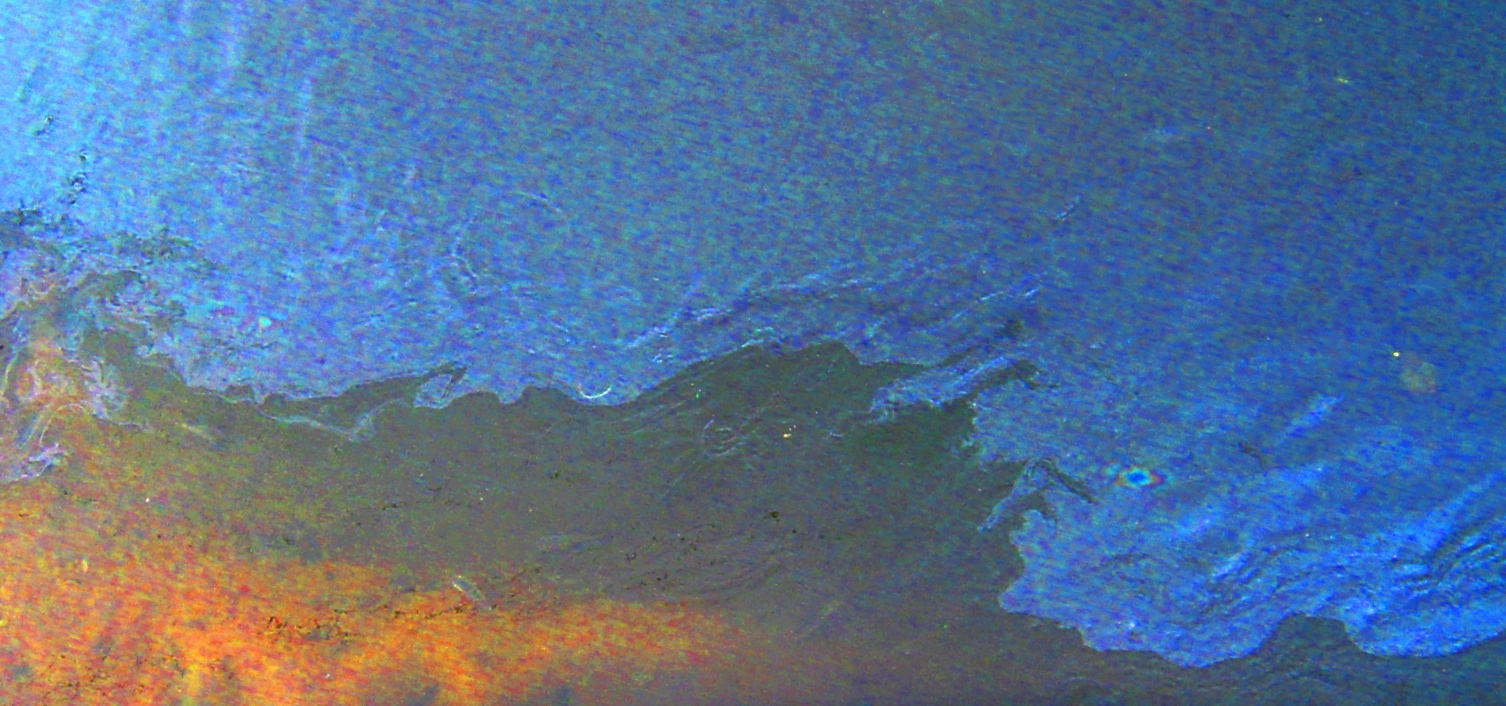
I am constantly on the lookout for opportunities for abstract photography, and the sight of oil and similar pollutants on the surface of my local river is too good an opportunity to miss. I have seen three significant such pollution incidents in the past 12 months, and the interesting aspect of the photos I took on each occasion is how different they are.
Although these photographs have been manipulated (increased contrast; increased colour saturation; altered tonal balance), it isn’t possible to change any of the pictures of one incident so that they resemble pictures from another. There are three significant variables that may account for the differences:
A photograph taken at the same time as the first one above appeared in Photographic Abstraction #3 under the title Rainbow, while the pollution incident depicted in the second photo was the subject of Troubled Waters. No photos from the third and fourth incidents have appeared previously.
I can say little for certain regarding the source of the pollution shown in these photos, except that the tributary on which the following photo was taken flows through Fanling’s industrial district, and careless disposal of oil-based waste is more likely here than anywhere else. However, once pollutants reach the main river, it becomes almost impossible to identify the source.
I am currently in the UK and will not be returning to Hong Kong until October, so this is likely to be my last post about the territory for some time, apart, that is, from a post that I have tentatively titled Saturday Morning Adventure, which will be about cycling and which I hope to finish soon.
17th April 2012.
8th November 2012.
21st March 2013.
Although these photographs have been manipulated (increased contrast; increased colour saturation; altered tonal balance), it isn’t possible to change any of the pictures of one incident so that they resemble pictures from another. There are three significant variables that may account for the differences:
- Light conditions at the time the pictures were taken. It was overcast when the first photo was taken, cloudy but bright for the second, and sunny for the third.
- The nature of the pollutants involved. All three photos above appear to be of light compounds such as kerosene or diesel, but contrast these with the picture below, taken in the winter channel of a tributary of the main river. The pollutant here appears to be heavy engine oil.
- The angle of the camera relative to the surface of the water. The first picture was taken from a footbridge over the river, looking almost directly down. The second picture was taken from the top of the embankment overlooking the river, while the third was taken from the water’s edge, making it the shallowest of the three angles.
A photograph taken at the same time as the first one above appeared in Photographic Abstraction #3 under the title Rainbow, while the pollution incident depicted in the second photo was the subject of Troubled Waters. No photos from the third and fourth incidents have appeared previously.
I can say little for certain regarding the source of the pollution shown in these photos, except that the tributary on which the following photo was taken flows through Fanling’s industrial district, and careless disposal of oil-based waste is more likely here than anywhere else. However, once pollutants reach the main river, it becomes almost impossible to identify the source.
5th May 2013.
I am currently in the UK and will not be returning to Hong Kong until October, so this is likely to be my last post about the territory for some time, apart, that is, from a post that I have tentatively titled Saturday Morning Adventure, which will be about cycling and which I hope to finish soon.
Labels:
art,
hong kong,
photography
Thursday, 9 May 2013
the mystery of the holes
Whenever I see any kind of natural phenomenon, I want to know how it happened, and why. A recent example has been the round holes that occur in mud banks in the local rivers, which I first noticed several months ago. The following photo, taken yesterday in the Shum Chun River on my way back from a journey to the west, shows how extensive this phenomenon is.
So how were these surprisingly regular holes in the mud of the river, each about 30cm in diameter, formed? I originally came up with two hypotheses, neither of which was even remotely convincing.
All the rivers in the northern New Territories have been canalized as a flood prevention measure, which means that the beds of the rivers were constructed using prefabricated concrete sections. And these concrete sections have neat rows of holes, each just slightly smaller than the holes in the mud. These holes remain full of water even when the river level is very low, making them ideal fishing holes for the local egrets, although it does appear, from passing observations, that this is the avian equivalent of shooting fish in a barrel. Unfortunately for my hypothesis, the holes in the mud are anything but regular in their spacing.
The second hypothesis centred on the notion of turbulence when the mud is underwater. The problem here is that it is impossible to imagine the kind of turbulence that would be required to produce so many holes, although one can imagine that the amount of water coming down the river for this to happen exceeds the design specifications of the flood defences.
It may be that the holes had always been filled with water whenever I saw them, so an obvious third hypothesis didn’t present itself: that the holes are the work of a horde of unknown creatures. This idea occurred to me only yesterday, when I saw the sandbank about 200 metres downstream from where the first photo was taken:
The holes at the water’s edge are filled with water, but those slightly higher are dry, and I was surprised to see that they are quite shallow. As can be seen in the photo, there is a small parapet of debris around each of the dry holes, which makes it highly likely that the holes were excavated. There is no sign of a burrow at the bottom of any of the holes, which would confirm the third hypothesis, so this photo is merely evidence, not proof. I suspect that crabs are the culprits, but this is just a guess at this stage.
You might wonder why I bother with such a trivial pursuit. After all, absolutely nothing of note hangs on solving this mystery. However, in an era of mobile communications, I prefer to pay attention to my environment, to listen to the sounds of nature rather than to a disembodied voice emanating from a smartphone, to look at whatever is happening in my immediate vicinity rather than at the screen of a mobile device. Unfortunately, my observations to date may have provided a mechanism for how these holes were formed, but I still don’t have any idea why. My best guess at the moment is that the holes are intended as a trap for potential prey, although I wouldn’t expect this to work if the holes are full of water.
So how were these surprisingly regular holes in the mud of the river, each about 30cm in diameter, formed? I originally came up with two hypotheses, neither of which was even remotely convincing.
All the rivers in the northern New Territories have been canalized as a flood prevention measure, which means that the beds of the rivers were constructed using prefabricated concrete sections. And these concrete sections have neat rows of holes, each just slightly smaller than the holes in the mud. These holes remain full of water even when the river level is very low, making them ideal fishing holes for the local egrets, although it does appear, from passing observations, that this is the avian equivalent of shooting fish in a barrel. Unfortunately for my hypothesis, the holes in the mud are anything but regular in their spacing.
The second hypothesis centred on the notion of turbulence when the mud is underwater. The problem here is that it is impossible to imagine the kind of turbulence that would be required to produce so many holes, although one can imagine that the amount of water coming down the river for this to happen exceeds the design specifications of the flood defences.
It may be that the holes had always been filled with water whenever I saw them, so an obvious third hypothesis didn’t present itself: that the holes are the work of a horde of unknown creatures. This idea occurred to me only yesterday, when I saw the sandbank about 200 metres downstream from where the first photo was taken:
The holes at the water’s edge are filled with water, but those slightly higher are dry, and I was surprised to see that they are quite shallow. As can be seen in the photo, there is a small parapet of debris around each of the dry holes, which makes it highly likely that the holes were excavated. There is no sign of a burrow at the bottom of any of the holes, which would confirm the third hypothesis, so this photo is merely evidence, not proof. I suspect that crabs are the culprits, but this is just a guess at this stage.
You might wonder why I bother with such a trivial pursuit. After all, absolutely nothing of note hangs on solving this mystery. However, in an era of mobile communications, I prefer to pay attention to my environment, to listen to the sounds of nature rather than to a disembodied voice emanating from a smartphone, to look at whatever is happening in my immediate vicinity rather than at the screen of a mobile device. Unfortunately, my observations to date may have provided a mechanism for how these holes were formed, but I still don’t have any idea why. My best guess at the moment is that the holes are intended as a trap for potential prey, although I wouldn’t expect this to work if the holes are full of water.
Labels:
hong kong,
mysteries,
nature,
photography
Saturday, 4 May 2013
optical illusion
When I worked in the Australian Outback in 1970, I used aerial photographs to assist my production of geological maps and the staking out of mineral claims on behalf of my company. When aerial photos are used for this purpose, it is customary for there to be an 80 percent overlap between adjacent shots. There are two reasons for this practice: to avoid the distortion that occurs close to the edge of such a photo; and to allow the viewer to look at the same point on the ground from two different angles.
The advantage of this last point may not be obvious, but consider that popular Victorian parlour toy the stereoscope. By looking at two slightly different images through a special viewer, the user could see a composite, three-dimensional picture. No one is going to lug a clunky wooden contraption around the bush, but small folding stereoscopes that will fit into a breast pocket have been around a long time.
And the resulting 3D pictures are remarkable. Trees stand out above their shadows, and small natural features are so easy to spot on the photos that it becomes straightforward to find wherever you are on them. However, there is an interesting phenomenon that happens occasionally, usually without warning. Trees and buildings become holes in the ground, and small hills become round hollows. This so-called ‘pseudoscopic’ image can be difficult to shake off when once seen, even though you know what the image should look like.
Which brings me to the point of this post. Last night, I was browsing through my folder of abstract photos when I experienced a similar phenomenon. I have the advantage of knowing the subject of the photo below, but for the purposes of this exercise let me just say that it is either a picture of pebbles on a beach or a kind of grating with irregularly distributed round holes in it. I could see only the incorrect interpretation, and I found it extremely difficult to force the optical processing system in my brain to switch images. However, the switch eventually took place automatically, and unexpectedly.
This is where you, the reader, come in. I hypothesize that each viewer will always see the same image first, that they will have difficulty switching to the alternative, and that this reflects how their brain is wired. Your assistance in either validating or refuting this hypothesis will be greatly appreciated. Please study the picture below before answering the following questions.
Which of the two images did you see first? Please record your answer in the poll on the right. Could you see both images? Did you have difficulty switching to the other image? Although this isn’t directly relevant to my inquiry, do you know what the real subject of this photograph is? I mention this because the origin of the round shapes is a mystery to me, and I have already disproved a couple of initially plausible hypotheses.
The advantage of this last point may not be obvious, but consider that popular Victorian parlour toy the stereoscope. By looking at two slightly different images through a special viewer, the user could see a composite, three-dimensional picture. No one is going to lug a clunky wooden contraption around the bush, but small folding stereoscopes that will fit into a breast pocket have been around a long time.
And the resulting 3D pictures are remarkable. Trees stand out above their shadows, and small natural features are so easy to spot on the photos that it becomes straightforward to find wherever you are on them. However, there is an interesting phenomenon that happens occasionally, usually without warning. Trees and buildings become holes in the ground, and small hills become round hollows. This so-called ‘pseudoscopic’ image can be difficult to shake off when once seen, even though you know what the image should look like.
Which brings me to the point of this post. Last night, I was browsing through my folder of abstract photos when I experienced a similar phenomenon. I have the advantage of knowing the subject of the photo below, but for the purposes of this exercise let me just say that it is either a picture of pebbles on a beach or a kind of grating with irregularly distributed round holes in it. I could see only the incorrect interpretation, and I found it extremely difficult to force the optical processing system in my brain to switch images. However, the switch eventually took place automatically, and unexpectedly.
This is where you, the reader, come in. I hypothesize that each viewer will always see the same image first, that they will have difficulty switching to the alternative, and that this reflects how their brain is wired. Your assistance in either validating or refuting this hypothesis will be greatly appreciated. Please study the picture below before answering the following questions.
Which of the two images did you see first? Please record your answer in the poll on the right. Could you see both images? Did you have difficulty switching to the other image? Although this isn’t directly relevant to my inquiry, do you know what the real subject of this photograph is? I mention this because the origin of the round shapes is a mystery to me, and I have already disproved a couple of initially plausible hypotheses.
Labels:
geography,
photography,
science
Subscribe to:
Posts (Atom)