Sunday, 26 December 2021

a morning walk

In a recent post, I mentioned being unable to ride a bike as a result of aggravating a long-term lower back injury, but at least I can walk, meaning that when I finally get back on my bike, I won’t have to deal with quite the same degree of loss of fitness as I had to put up with after enduring a tedious 21-day quarantine when we came back to Hong Kong in September.

Although we have quite a few walking options from where we live, in a village a short distance east of Fanling, we usually head south or east. However, Paula had said that she wanted a longer walk, so I thought that if we headed west, following the Ng Tung River, and return via the Shek Sheung River, then that should meet her requirements.

Unfortunately, our local river isn’t quite the scenic delight it was a year ago, with work on the so-called Fanling North bypass now steaming ahead:
To say that this bypass is unnecessary is an understatement. Ma Sik Road, which runs alongside the line of high-rise apartment blocks that you can see in some of the photos below, is a dual carriageway that joins Sha Tau Kok Road, also a dual carriageway, which is the main road east out of Fanling. Where’s the need for another bypass?

Anyway, the first new obstacle to be negotiated on our way downstream is a temporary footbridge:
I have no idea why part of the bridge has been caged off, which makes the usable part uncomfortably narrow if you happen to meet someone coming the other way. The sign reads ‘Please dismount and push’ and is repeated every 2 metres across the bridge—an injunction that the majority of cyclists ignore:
It feels very strange to walk along too: the red, black and grey sections are made up of rubber pimples of different sizes!

Having crossed to the north side of the river downstream (see below), the new road will recross the river just upstream from the temporary footbridge. This is a shot of the work done here to date:
It is still possible to capture a few picturesque scenes as we make our way downstream. This is a view of the first permanent footbridge from the south side of the river:
…and this is a shot of the river, looking downstream, from that first footbridge:
Construction work on the downstream crossing point of the bypass, next to the second permanent footbridge, can be seen in the distance. And this is what it looks like from a much closer viewpoint:
This is an even closer look at the construction work here, first on the north bank:
…then on the south bank:
There is currently no construction work downstream from this point, but there will be, eventually. This is a view of the river from a point downstream from a minor road that crosses the river:
The high-rise buildings in the distance are in Shenzhen.

And this is a view of the bridge carrying Man Kam To Road, a major highway into China, looking back upstream:
The section downstream from Man Kam To Road is quiet and peaceful, but it eventually comes to an end at the main railway line into China. However, it’s possible to cross the railway via a tunnel:
When I first started exploring ‘out west’, this is the way I came. Being on a bike, I didn’t notice whether there was a sign here, but on foot, you have time to check out this kind of thing. The sign on the left reads:
WARNING
TO PREVENT ACCIDENTS
PLEASE STAY AWAY
I remember when I first started using this tunnel, I wrote to the local district council to ask whether it could arrange for the floor of the tunnel to be concreted. It is broken and rife with potholes, but nothing was ever done to rectify it. However, the tunnel isn’t the problem here. This is:
I estimate the slope angle at around 35 degrees, but the difficulty on a bike here is not just the steepness. It’s a 90-degree turn onto the start of the ramp, so it isn’t possible to hit it with any momentum, and if you do stray offline and hit one of the lumps on either side, you will stall immediately. In fact, the first time I cycled this way, I assumed that it was impossible, so I would get off and push my bike up the slope, but I eventually gave it a try, and to my surprise, and delight, I managed to ride up the ramp.

I wasn’t always successful though. It didn’t help that my tyres were often wet after riding through puddles in the tunnel, and I occasionally failed to hold the line and ended up hitting one of the lumps. Anyway, I found a much better route west years ago, and I no longer cycle this way. However, I still pass the exit point, and I’ve noticed that it remains popular with recreational cyclists, so I assume that accidents do happen here. I’m not about to disclose the alternative though, because it involves cycling through a squatter area, where large groups of cyclists would be a nuisance.

The path then emerges onto a Drainage Services Department (DSD) access road just downstream from the confluence of the Sheung Yue River (right) and the Shek Sheung River:
Until a few years ago, we used to see a feral buffalo regularly further up the Shek Sheung River, and, naturally we called him ‘Bill’. I took a photo every time we saw him, which you can see in Buffalo Bill, although, sadly, he’s no longer around.

Had we been cycling home from this point, we would simply have followed the cycle track that starts where the DSD access road ends, but being on foot, I thought that we should cross the railway via a footbridge that leads to a tight cluster of nine villages that now form part of northeastern Sheung Shui. My aim was to show Paula the historical buildings in the area, which I’d visited several years ago but I knew Paula had never seen. These will be the subject of a future post, but here is a view of the front of the Liu Man Shek Tong Ancestral Hall, which was built in 1751:
After our tour of the local history, our route home would take us across the forecourt of Sheung Shui Fire Station, and just as we were about to cross, we became aware that a fire engine was about to pull out:
I did think that more appliances were getting ready, but we had time to both cross the forecourt and the road. Then I looked behind, and a second appliance was on its way out of the station:
After taking this photo, I put my phone away, but I should have known better. I knew that the standard protocol for urban fires is for multiple appliances to attend, no matter how small the reported fire. Had I waited, I might have captured a photo of three fire engines in a line roaring off down the road.

The rest of the walk home was uneventful.

Thursday, 23 December 2021

another fine mess on the ground

‘A mess on the ground’ has been a running joke between Paula and me for several years now. It has developed from a conversation that Paula had with a fellow passenger while travelling to Fanling station from our village. She happened to remark that the cotton trees (Bombax ceiba) were looking particularly beautiful that year. The reply?

“Yes, but they leave a mess on the ground!”

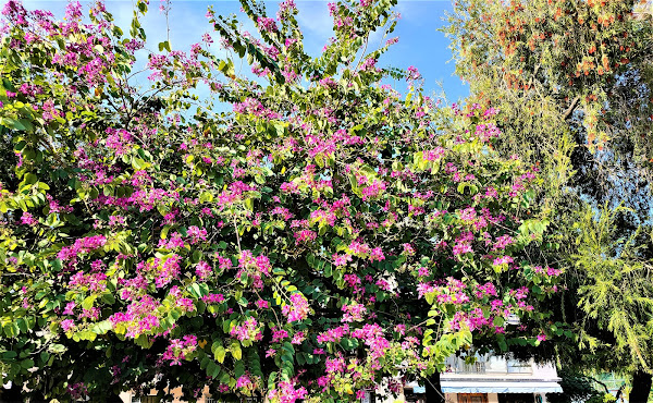
There aren’t any cotton trees in our village, but there is a line of bauhinia (Bauhinia variegata) trees, which produce Hong Kong’s ‘national’ flower:
The red in the top right of this photo is produced by bottle-brush flowers.

I took the photo more than a month ago, and for the past week the flower petals have been falling to the ground more and more frequently. In the past, I’ve often thought how nice it would be to see this pink debris accumulate. Unfortunately, however, this never happens, because one of the Food and Environmental Hygiene Department’s employees based in our village sweeps everything up first thing every morning before carrying out her other duties. She probably thinks it’s a mess anyway.

However, yesterday was different. We’ve just endured two days of constant rain, the first for two months and the result of being hit by the outer rain bands of the remnants of Super Typhoon Rai, which had ravaged the southern Philippines a few days ago. The constant rainfall accelerated the fall of flower petals, and I don’t think any of what had accumulated on the ground had been swept up while it was still raining.

We were on the minibus from Fanling station to Siu Hang, a village on the other side of the Ng Tung River, when I looked out of the window and saw the result. We were due to alight about 25 metres further along the road, and when we’d done so, I said that I simply had to go back and take some photos:
This is a close-up of the area of interest in the previous photo:
I walked around the trees in an anticlockwise direction, stopping to take photos at key points:
The previous two photos are of a separate line of trees on the other side of the entrance to the car park.
You may have noticed bars of sunlight in some of the photos. It was quite late in the day, and when we got home, I decided to go up onto our roof and take some photos of the sunset:
Not especially noteworthy, you’re probably thinking, but this is a view looking northeast! I particularly like the orange cloud blanketing the mountain ridge in the distance, which is in mainland China.

These are the first and last photos that I took looking west:
Thanks to the ubiquitous air pollution here, sunsets like this are not common, but they are nowhere near as rare as the kind of mess on the ground that I documented above.

Friday, 17 December 2021

an unexpected discovery

Whenever we go out for a walk or a bike ride, Paula usually leaves it up to me to decide the route, but a few days ago, I thought that I should leave it up to her to determine the route for that day’s walk. She opted to follow our local river downstream, where in the past we could simply follow the Drainage Services Department (DSD) access road that runs alongside the river.

The first part of this road, which is gated off and therefore only accessible by cyclists and pedestrians, is straightforward, but it is soon blocked by construction barriers, next to a temporary footbridge that allows people to cross to the other side of the river, where there is a makeshift road that was constructed by slathering concrete onto the ground. It isn’t ideal, because it allows access by motor vehicles to the ‘development’ area.

As we walked along this road, I happened to ask, rhetorically, where the goats go now that the area has been denuded of vegetation. There is a large herd of free-range goats in the area, which I saw a couple of weeks ago before the area being cleared was blocked off.

“There!” said Paula, pointing to the river bank under the first permanent footbridge that crosses the river.

I was reminded of an incident a couple of years ago, when it was still possible to walk into Fanling by a direct route. I happened to remark that I hadn’t seen a squirrel for ages. As if it had heard me, we immediately saw a squirrel scurrying up a nearby tree.

Anyway, I waited until we were well downstream of the footbridge before taking this photo:
The goats must have reached here by jumping the fence between the river and the road at some point. Along this section, the DSD access road no longer exists, although there is a path, which few people know about, on the far side of the construction area.

Further downstream, a minor road crosses the river, and beyond that there is currently no construction, so it remains a pleasant location for a walk. However, I’ve only ever cycled along this section, so although I was aware of this tree, I hadn’t noticed that it has completely engulfed the fence:
This is a view looking downstream, in which you can see a bridge that carries Man Kam To Road across the river:
This road is a major highway that leads to the border and carries a lot of freight traffic into and out of China. When we reached it, I learned that Paula’s plan had been simply to double back the way we’d come. Why not follow Man Kam To Road south and come back by a different route, I suggested.

That turned out to be a mistake, a serious error of judgement, because the pavement running alongside the road is extremely narrow, and having big trucks roar by isn’t pleasant. However, after a short distance, I spotted a path leading off to the side that ran alongside a large nullah (storm drain):
The streetlight was an encouraging sign.

“Look!” I said. “There appears to be a park ahead on the right”:
At one point, the path, which had been running tightly alongside the nullah, veered away to the left:
…and we were immediately confronted by a truly impressive banyan between the path and the nullah:
“Bloody hell!” I exclaimed.

You will probably understand my reaction. It certainly knocks the banyan in the forecourt of the Big Tree Temple, which I described in my last post, into a cocked hat! The large leaves around the base of the tree are elephants’ ears.

Here the path crosses to the other side of the nullah:
…and here both the path and the nullah turn abruptly to the left:
I imagine that most readers will know someone who had a rubber plant in a pot in their living room. Well, this is what they could become if allowed to grow unchecked, complete with prop roots:
There are several rubber trees like this along the perimeter of what I’d originally thought was a park but eventually realized was a school’s playing fields:
This cannot possibly be a government school. I base this opinion on two factors: if it had been a government school, the playing fields, which boast two football pitches and a hockey pitch, would have been built on; and no government school would include the word ‘innovative’ in its name.

All this time, I’d been wondering whether we would eventually reach a dead end, which is quite common with DSD access paths, and we’d have to double back:
Fortunately, though, there is a continuation path:
I invariably photograph impromptu wayside shrines that I come across, like the one near the start of this continuation path, but it was only when I looked at the photo I’d taken here that I spotted something odd:
This is a closer look at the main area of interest:
The figure on the left is obviously the Buddha, but why are there only two of the three immortals? The left-hand figure is Luk, who is usually portrayed with a winged hat, which symbolizes power and influence—such hats were once worn by civil servants—but he can also symbolize prosperity, the character on the cup in front of him. Next to him is Sau, who represents longevity, which is also symbolized by the peach in his left hand.

The missing immortal, Fuk, is usually portrayed with a scroll in one hand and a small child in the other, which suggests that the Buddha has been assigned this role here. This does seem odd though, because Fuk is usually associated with good fortune, the third component of an ideal life in Chinese culture. The figure on the right is an anonymous goddess. Notice that the cup in front of Luk, which probably contains rice wine, is larger than the other cups. The supplicant here clearly prioritizes prosperity, which probably reflects the location—an unofficial squatter site.

And notice too the child’s toy, which may be a model of the Space Shuttle or a delta-wing military aircraft. The significance of this is completely beyond my ability to explain.

After a short distance, this path emerges onto Tin Ping Road, which I’ve cycled along dozens of times, but I never noticed this (left of the parked car):
Of course, my oversight is because I don’t consider it prudent to look around me when cycling along urban roads.

This is a satellite photo of the area I’ve just described:
The two yellow X’s show the start and finish of the route, starting from the more northerly X and looping around the school playing field, indicated by a blue X. The Ng Tung River can be seen towards the east and in the northwest corner of the photo.

By the time we’d returned to the DSD access road on our way home, it was getting late, and I took this photo looking downstream from the first permanent footbridge across the river, having followed the little-known path that I referred to above:
After we’d crossed the temporary footbridge mentioned above, I took these last photos, which show the temporary footbridge:
…and which seem like a fitting finale to an extremely interesting excursion that exemplifies why I love Hong Kong: you never know what will be around the next corner.