Although I first visited the San Tin area two years ago (New Fields), my primary focus of attention was the fish ponds in the area (Pond Life). However, last winter, I decided to check out Tun Yu Road, which runs from Castle Peak Road—a major traffic artery—to an unmanned crossing point into China, although I didn’t know that this was the case until I reached it.
There was also a second road, which branches off Tun Yu Road before the latter narrows from a conventional width to a single-track road with passing places:
This is a fine bridge to be crossing what is merely a small river, so I wanted to see where it would lead to. However, I’d barely turned the corner off the bridge:
…when I came to a point where several large trucks had been parked on both sides of the road, so I concluded, wrongly, that it merely led to yet more quasi-industrial sites—there are several on the wider section of Tun Yu Road—and I decided to turn back.
However, back in October, I was cycling in the area and decided to take another look. This is a satellite photo of the area:
The bridge at the start of the road is circled. The cruciform shape in the centre of the image is a major freight crossing point into and out of China, which is fenced off along the sides (the fence can be seen in several of the photos below). The MTR’s Lok Ma Chau spur line can be seen snaking its way to the terminus in the northwest corner of the image, while Tun Yu Road is clearly visible to the west of the crossing point.
And this time there were no parked wagons, so I continued:
There is one quasi-industrial site along this road, but it doesn’t appear to be particularly busy. This is the turn-off, to the left, to that site:
Just around the corner seen in the previous photo, there is an official-looking building:
According to Google Maps, a notoriously unreliable source, this is the ‘Department of Health (Outbound) Office’, but this is what is actually written on the sign on the wall:
Customs Detector Dog Division
Lok Ma Chau Dog Base
Immediately after passing the Customs building, there is a large pond that is choked with a plant that I’ve seen in some of the disused fish ponds along the frontier road. I can’t provide a specific identification, although I imagine that it is some type of reed:
And then it is a guaranteed quiet road:
There are two things to note about the previous image: the floodlight—these occur every 15–20 metres, although I can’t imagine their being turned on at night nowadays—and the speed limit sign. I can easily exceed 8km/hr, even on a bike!
Whatever hit this pole was probably also exceeding the speed limit:
And this is a final view of the pond, just before it comes to an end:
The following sequence of photos gives a good idea of how quiet the continuation of the road is:
…and how pleasant it is to cycle along.
Believe it or not, this is a passing place:
On a recent foray down this road, Paula and I encountered three dogs, which I assumed were feral and which I also assumed had crossed the border from China, for reasons that I explain below. Yesterday, while taking the photos for this report, I spotted two more. The first dived into the undergrowth the moment it saw me, but the second merely ambled down the road, giving me a chance to take this photo:
The railings in the distance lead up to a bridge over a slime-filled tributary to the river that runs parallel to this road on the left, while the next photo was taken from the bridge, looking back in the opposite direction. It shows the Lok Ma Chau spur line passing overhead:
And this is where the road eventually leads to:
I took the previous photo on my first foray down this road, but some serious clearance of vegetation has taken place since:
If you look closely at the next photo, you will see that there is a hole in the fence closest to the camera position:
The sign in the middle of the photo proclaims that this seemingly abandoned road has a name: Sai Kwo Road. This does seem bizarre, given that we cycle along many roads that are unnamed. But this sign is repeated at regular intervals along the road—you can see it on both sides of the road in my first photo above.
And here’s another hole:
The fence here is in extremely poor condition, and there are at least half a dozen other holes like the ones pictured, which is why I think the dogs we’ve seen came through one of them—they’re unlikely to have crossed the river, or followed the road from its beginning, especially as there’s nothing for them to eat here.
So if this road leads nowhere, why do we continue to cycle along it. That should be obvious: it makes a pleasant interlude between the more demanding sections of our ride, and it adds a couple of kilometres to the overall distance cycled!
I wrote about ‘ignoble hill’, a large squatter area on the northern edge of Fanling, last year, and in that report, I included photos of two murals in what might whimsically be called ‘the main street’. However, there are others in side alleys, and this report is a comprehensive survey of everything I’ve come across when cycling through the area.
I should point out that ‘ignoble hill’ is not the area’s official name. I gave it this rather facetious sobriquet as a counterpoint to Noble Hill, an upmarket housing estate on the opposite side of Ma Sik Road, a busy four-lane dual carriageway that marks part of the northern and eastern boundaries of Fanling. This is a satellite photo of the area:
You can see that it is laid out in quite an orderly fashion. Ma Sik Road cuts across the northwest corner of the image, while the road that slices across the southeast corner provides the only access into the edge of the area for motor vehicles. The area to the southeast of this road is not part of ignoble hill.
The first mural that I encounter when cycling through the area is on the gable end of what I’ve conjectured is some kind of community building at the northern end of the area (marked by a blue X on the satellite photo). There are always cars parked here, so I’ve been unable to take a straight-on photo of the entire mural. This is my best effort to date:
…and this is a view of the left-hand end obscured by the parked car:
This is a real window!
My route then follows an excruciatingly steep path through the wooded area towards the red X, which marks the top of the main street. There are four murals on the walls of this alleyway, two of which didn’t exist when I wrote my original report. This is the first one you will encounter, on the left:
I’ve included the third photo to provide a better look at the dog enjoying an ice-cream cone, which I think is hilarious.
The next mural has a distinctly aquatic theme:
This mural is directly opposite the first of the new murals:
The second new mural can be glimpsed further down the alley, and the tower in the distance is part of Noble Hill. You can tell that it’s an upmarket estate by the height—only 15 storeys—and by the existence of penthouses.
The next two photos provide more detail of this new mural:
The Chinese characters on what I take are meant to be mah jong tiles—even though it takes four to play the game—read ‘si dor’, which is a transliteration of ‘store’. And there is a store at the top of the alley.
And this is the fourth mural:
The Chinese characters translate as ‘five street’, so there are formal addresses in ignoble hill!
Further down the main street, there is a cross-alley to the right that is navigable on a bike (most of the cross-alleys have flights of steps), and this is a mural that I spotted here:
I had thought that I could get everything in one shot, but the mural extends to the right, so I took an additional photo on a subsequent visit:
The end of the cross-alley is marked by the next mural:
This alleyway is extremely narrow, making it impossible to get it all in one photo, so here is what this mural looks like from the left:
…and from the right:
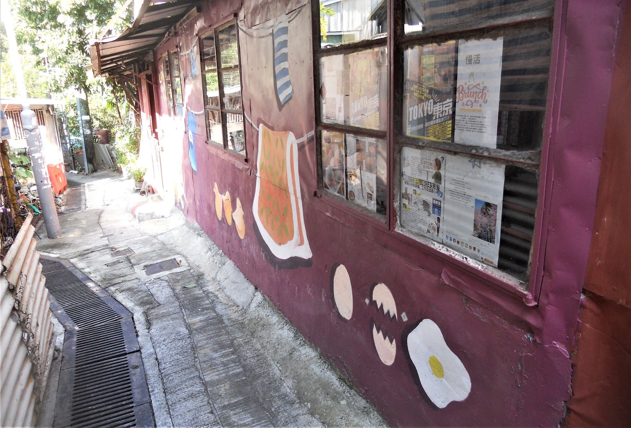
You will notice the sunlight on the left-hand end of the mural in the first photo, which obscured the detail of the chicken laying eggs on the dog in this photo and in my original photo from the left, so I took a replacement photo on my follow-up visit.
The final mural is located around the corner to the left at the top of the alley in the previous photo:
I’d only ever cycled past this mural in the past, and it is located above eye level, even on a bike, so I didn’t notice it. However, my follow-up visit was on foot, and my attention was drawn upwards by the red, white and blue vertical stripes, which may be intended as part of the work, as I walked past. The Chinese characters on the bottle proclaim the contents to be an orange juice drink that used to be popular with young children. In fact, all the items depicted in this mural can be recognized as children’s favourites.
Although all the artwork here is best described as ‘primitive’, I still find it interesting. I do wonder what the residents think though, because it is my guess that it is all the work of outside artists. It certainly brightens the place up.
Last week started well but then went steadily downhill, although Sunday was something of a landmark. Since completing my 14 days of home quarantine in mid-October, I’ve been getting out regularly on my bike, racking up at least 70km per ride. However, perhaps it’s my age, but I always felt far too tired the following day to consider going out again. That changed on Sunday.
Although I’d completed a 70km ride the previous day, I felt that I couldn’t miss doing ‘the final frontier’, which is only practical on Sundays and public holidays because of the amount of industrial traffic on key road sections. This, my favourite ride, passes through a long section of what had been, until 2016, part of the ‘frontier closed area’, so I’d never carried out any exploration northeast of Fanling until I heard that this restriction had been lifted.
Over the past few years, I’ve usually done this ride by myself, because Paula goes to church on Sundays, but following a recent surge in coronavirus cases, she has had to make do with a virtual church service, so she would be available once the service had finished. And the final frontier is only about 50km, so I did a short ride while she was otherwise occupied. I opted for the ‘detour de force’, which I hadn’t done previously since returning to Hong Kong.
Once out on the ride, we stopped at a public toilet on Ng Chow Road, and while Paula was using the facility, I noticed a rather grand village house that stood alone nearby:
The vast majority of such houses, which are restricted by law to a maximum of three storeys and a maximum footprint of 700 square feet, have a far more prosaic design, and most are subdivided into three separate apartments, but I suspect that this house has a single occupant. The clues include the difference in balconies between the first and second floors, and the guardian lions at the gate, which could well be solid bronze.
I took the photo because I thought that I might compile a collection of photos of other village houses to compare architectural features (see below).
The ride went well enough, although on the climax, ‘the switchback’:
I had to drop to the small chainring on the first hill, which is a bit of a grunter, for the first time ever. The video starts from the top of that first hill. It isn’t often that I come across hills in Hong Kong where brakes are not required—except in an emergency, of course—but the first two downhills are real screamers where I’m exceeding the speed limit for motor vehicles (50km/hr) as I hit the bottom.
Although that would have been enough to qualify as a good day’s work, I thought that a detour to take in an alleyway that connects the Ng Tung River with Fu Tei Au Road would make a fitting conclusion to the ride. As you can see from this photo, the exit is quite steep:
The following day, I wasn’t about to do any more cycling, so I decided to walk to the villages of Kwan Tei and Fu Tei Au, a couple of kilometres east of Fanling, to take a few photos of village houses. Having done so, I was on my way home when I was suddenly accosted by a man who kept screaming:
“Why did you take a photo of my home?”
I would have told him, but I couldn’t get a word in edgeways. And, he told me, he’d called the police. I did consider sloping off when he wasn’t paying attention, but I thought it better to wait for the coppers, because as far as I was concerned, I’d done nothing wrong. When the police finally arrived, I gave them my camera to examine, and they happily accepted my explanation that I merely wanted to compare architectural features. I imagine that the screaming man thought that I had some criminal intent.
And the week didn’t get any better. On Wednesday, Paula wanted to do ‘the long and winding road’, which we had yet to do this winter. An Australian friend described this ride as “thrilling”—and that was before I upgraded it to include ‘the spiral ramp’! Everything went well enough until we embarked on ‘the iron bridge path’ segment:
The last time we’d done this, the section between 2.36 and 2.50 on the video had been choked with vegetation, and, having decided to try to ride through it, I’d then spent 15 minutes removing twigs and other vegetative matter from my chain and gears. I was prepared to get off and push this time if it was still overgrown, while making a mental note to avoid it in future.
But it had been cleared. Unfortunately, all the vegetative debris had simply been piled up at the start of the previously overgrown section, leaving a fairway no more than 30cm wide—OK for anyone on foot, but far too dangerous to attempt on a bike, given the two-metre drop on the right.
Worse was to come. The dirt road section:
…provides access to a small temple, and for the past few years to a small motocross area where we often noticed people riding scrambler motorbikes and small four-wheel-drive vehicles. This time, however, we couldn’t help but notice that earth-moving machinery was being used to expand this area, and when we embarked upon the dirt road, it was obvious that it had been altered significantly. We had no option but to proceed with extreme caution.
Towards the end of the ride, the route follows a Drainage Services Department (DSD) access path that runs alongside a large nullah (storm drain). This gets overgrown too, but it’s cleared from time to time by DSD staff. However, this time the trimmings had simply been left in place. We could ride over this, although I was concerned that a wooden splinter might puncture one of my tyres—a concern that proved remarkably prescient. Paula did get some vegetation in her gears, which took a while to remove.
So the long and winding road is no longer going to be a regular excursion in future, although I will have to work out some way to continue to test ourselves on the spiral ramp.
After this disappointment, Paula had to head off home because she had something else to do, so I thought that I would do some more by myself. I decided that I would start with ‘ping kong ping pong’, but as I was riding along the road to the village of Ping Kong, I suddenly began to hear a cyclical click from one of my tyres. I thought that I must have picked up a piece of paper or similar debris, but when I stopped to investigate, this is what I discovered:
It had penetrated the tread of my back tyre. I don’t carry a spare inner tube, or repair equipment, so I had to push my bike to the bike shop we always use in Sheung Shui, a distance of about 3km. I was in no mood to continue after my bike had been fixed, so I came home. And, according to my speedo, I’d done just 4km that day! The battery obviously needed replacing.
On Friday, after obtaining a new battery for my speedo, we would do ‘the frontier road’:
As you can see from the video, this used to be a quiet road with almost no traffic (it had been part of the ‘frontier closed area’ until 2013), but in the past year or so it has become infested with construction traffic. This road was never built to handle heavy vehicles and is now pitted with potholes, some of which are impossible to avoid. On this occasion, we encountered no fewer than eight big tipper trucks laden with earth on the section of the road east of a police operational base—and the road is so narrow here that you have to get off it completely to allow one of these behemoths to pass.
West of the police base, the road has been widened, so this isn’t a problem, but I began to think about returning via a different route to avoid any more encounters with tipper trucks—the frontier road has usually been an out-and-back excursion. The obvious choice would have been the new cycle track connecting Sheung Shui and Yuen Long, but both Paula and I think it’s boring, as well as being very poorly designed. However, a few years ago, I’d discovered an alternative over the hills that we’d stopped using because it involves a short but difficult portage section. On our way to join the cycle track, I suddenly remembered this alternative, so that’s the route we decided to take.
None of this route seemed remotely familiar—I wasn’t sure we were even on the right road—and at one point we came to a massive construction site (constructing what, in such a remote location, I cannot say). We had to cross over from one road to another via some steel plates that had been placed across some otherwise open trenches, and until it was too late, I didn’t notice that they were wet. Suddenly, my front wheel slid violently to the left, and I was on the deck, the impact concentrated on the fingertips of my left hand.
Although I was able to get up, gingerly, almost straight away, the index finger of my left hand did feel quite sore. However, we continued, and eventually we reached a location that we both recognized: a flight of rudimentary stairs that was the portage section I referred to earlier. In this direction, the steps lead downhill, which is easier, and I was able to get my bike down them without too much trouble.
In fact, we continued with our planned route, which involved a sequence of narrow but quiet roads through an area southeast of the large village of Hang Tau. We eventually reached a small pavilion next to ‘the witch’s house’, where we always stop for a short break. Our next objective would be ‘swiss roll’, which both Paula and I rate as harder than the spiral ramp! My finger was definitely sore though, and I couldn’t grip the handlebar as tightly as I would have liked, so I suggested that we miss it out. However, having set off, and before we had to make the turn towards swiss roll, I suddenly decided that I can still do it. And I could!
The following day, we were walking through Luen Wo Hui, the easternmost district of Fanling, when Paula noticed that the local 7-eleven convenience store was selling 500ml cans of Heineken for just HK$7 each. She suggested that we come back later to buy a few, so we returned with my airline carry-on wheeled suitcase and took home a full case.
As Shakespeare wrote, all’s well that ends well. I think I’ll have another beer.
There are five ways out of our village. Two are single-track roads (with passing places); one is a footpath that eventually reaches the same place as one of the roads; and one is the footpath we follow if walking into Fanling. The fifth route is the Drainage Services Department (DSD) access road that runs alongside the Ng Tung River:
Although the signs are explicit—‘No Entry’—it didn’t take us long to notice that nobody appeared to pay any attention to them, and we found that a stroll along the river was a pleasant experience, because although the DSD access road is not accessible to motor vehicles, pedestrians and cyclists could simply pass through the conveniently provided gap.
Other branches of government were clearly aware that this road was a popular leisure resource for locals:
I wrote in 2011 (Owt Fresh?) about the solar-powered streetlights that had been installed by North District Board while I’d been away in the UK for the summer, and prior to that, the Home Affairs Department had built covered seating at strategic intervals along the river, presumably after consulting the DSD. Although the DSD continued to maintain its ‘keep out’ stance (I took the above photo last winter), this prohibition has now been relaxed. ‘No Entry’ is no longer inscribed on the signs at the access point.
Unfortunately, back in October signs appeared warning people that access would be prohibited from 1st November. The signs referred to a ‘Fanling east bypass’, which struck me as both unnecessary and unwelcome. The eastern boundary of Fanling is currently defined by Ma Sik Road, a four-lane dual carriageway that carries a lot of traffic but is never congested, but between this road and the river, there is a wide area of land that was extensively cultivated when we moved here in 2008.
However, in 2011, a local property developer began fencing off the area (Turf Wars), and construction of what I imagine will eventually be a high-rise private residential estate began a couple of years ago. I suspect that the existence of this estate is the main reason behind the plan to construct a ‘bypass’ even further east.
We had been using this DSD access road regularly whenever we wanted to cycle out west, but there are alternatives. However, these involve following cycle tracks through the urban area, which I would prefer not to have to do, because they involve crossing roads at light-controlled junctions, where legally I’m required to get off and push, although I never do so. In any case, the prohibition on the DSD access road hasn’t been rigorously enforced, although some sections have been temporarily blocked off. These can be avoided by paths that only locals like myself know about, but as you can see below, the level of destruction that is envisaged here is truly horrifying, and access for cyclists, and pedestrians, will be impossible.
A few days ago, I noticed that all the trees along the river had been tagged either ‘retain’ or ‘fell’:
…and I couldn’t believe the extent of the planned destruction, which has already started:
These trees are all slated for ‘demolition’:
There are two footbridges across the river, and I’d initially assumed that the planned tree clearance applied only to the section downstream from the first bridge, but that was because the tagging process hadn’t been completed. Every tree between that first bridge and our village is also doomed:
…including two trees that are around 15 metres high:
This implies that the proposed bypass will eventually reach our village, from which, as I pointed out above, the only exits for motor vehicles are single-track roads. But there are other ‘obstacles’ in the way of clearance, and I do wonder whether they will go too. This is an example of the covered seating that I referred to above:
…while this is a pavilion and seating area, outside the DSD road, that was already there when we moved into the area:
This is a view of the final section of the road before it joins the road linking our village with the nearby village of Siu Hang:
The two eucalyptus trees in the photo are also about 15 metres tall.
The building in the previous photo is a public toilet that was opened just a couple of years ago:
Is that also slated for destruction?
Incidentally, there aren’t many trees on the river side of the DSD road, but the one in this photo has also been tagged ‘fell’, even though it has a trunk almost a metre in diameter, and it doesn’t appear to interfere with any planned new road hereabouts (I featured the red flowers that you can see in Autumn Flowers #3):
Hong Kong is always changing, but from my perspective this is one change too far!
I'm an ex-geologist, an ex-Outward Bound instructor and administrator, an ex-journalist, and an ex-book editor. I still consider myself a scientist. I'm now retired and spend seven months of each year in Fanling, a town in Hong Kong's New Territories, and five months in Penrith, my home town in England.
Although many people regard graffiti as just another form of vandalism, I’m a huge fan and consider it a valid art form. The Writing on the Fence, which I recorded in Manchester in 2018, underlines my view.