Although Paula and I agree that the most enjoyable bike ride we’ve done this year was our ride up to Haweswater (
Haw! Haw! Haw!), in terms of scenery, a ride that we did last week comes very close, even though we didn’t see any lakes.
We started by heading to Greystoke, a village about five miles west of Penrith. We didn’t follow the B5288, which we consider too dangerous for cyclists because of the speed at which some cars are driven. Instead, we cycled through Newton Reigny and Blencow, which adds a couple of miles to the ride but is far safer. Because we cycle through all three of these villages quite frequently, I didn’t take any photos, but we continued west of Greystoke along the B5288 because it’s preferable to the road that runs parallel to the main road to the north—the problem here is racehorses, which can be both difficult and dangerous to overtake on such a narrow road.
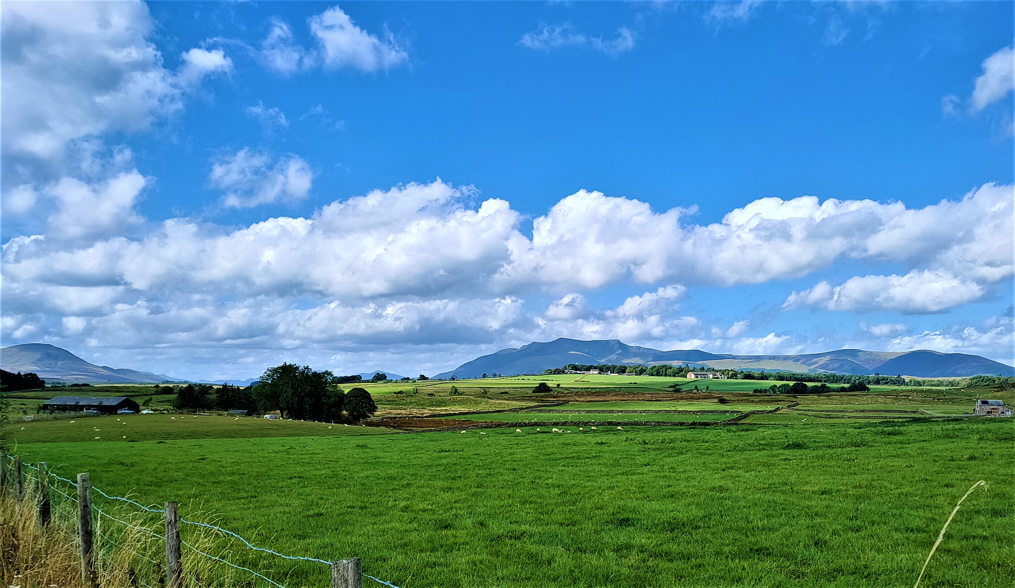
On the way to Motherby, a hamlet about two miles further down the road, I stopped to take this photo:
The significance of this photo may not be obvious, but it was our first sighting of a mountain that dominates the next few miles (see below).
And this is a view looking back down the road, with the Pennines on the distant horizon:
We stopped briefly in Motherby, where I took this photo looking back:
…and this photo showing the road ahead:
Immediately after leaving Motherby, I stopped to take this photo of the mountain:
Relatively few locals have an extensive knowledge of local toponyms, but everyone recognizes this, one of the few mountains in the Lake District with a name of Cumbric origin (Blencathra). Mind you, they are much more likely to refer to it by a name that reflects its distinctive and easily recognizable profile (Saddleback).
My objective was to follow the former main road to Keswick as far as the turn-off to the village of Mungrisdale. It has long since been superseded by the A66, to which it runs parallel, although I didn’t know how much of it still existed (it isn’t marked on my map). This photo of Saddleback was taken shortly after joining the old road:
The next photo shows a pile of logs by the side of the road a short distance ahead:
Shortly after we’d stopped to take some closer photos of the logs, two pick-up trucks pulled up, and when the driver of one got out of his vehicle, I asked him where the logs had come from.
“The wood at the top of the hill [on the right]” he answered.
“Are there any trees left?” I asked.
“Not many!” he replied.
It didn’t occur to me to ask what they would be used for, and I’m no expert on the subject, but there are several commercial plantations in the area, all of conifers. You can make your own guesses as to the ultimate use of the logs. Pine furniture or wood pulp? This photo provides some indication of just how many logs had been piled up here:
I stopped to take the next photo mainly because of the stand of pink flowers on the left. This is rose bay willow herb, which is a glorious and common sight on roadsides because it always grows in large stands like this, although in this case it was late summer, so the display had faded:
This is the final photo that I took of Saddleback:
As I mentioned above, I had no idea how much of the old road still existed, and on two occasions it diverted from its arrow-straight trajectory to join the A66. Fortunately, however, in each case there was a dedicated cycle track running alongside a road that no cyclist in their right mind would want to ride along. The second of these ended at the road to Mungrisdale, and we could get away from the noise of fast-moving traffic for the remainder of the ride.
I didn’t stop to take any photos on our way to Mungrisdale, although there were one or two locations that in retrospect would have been ideal. Instead, I took the next photo as we reached Mungrisdale:
And this is the reason we chose to stop here:
…while this is a view from the bench:
We continued through Mungrisdale, which is a small village, and I stopped to take this photo of the road ahead on the way to Mosedale, which is even smaller:
Notice that the hillside on the left comes right down to the road, although there are no hills on the road itself along this section.
I took the next three photos from the same place just outside Mosedale, most of which is located at the start of a dead-end road that leads up this valley, which was carved by the headwaters of the River Caldew:
I have particular memories of this valley. As a student of geology at Manchester University, I chose it as the site for my final-year mapping project in 1966/67. There is an abandoned wolfram (tungsten) mine at the end of the road, the mineral being part of the ‘juices’ from the Skiddaw granite intrusion that underlies the upper reaches of the valley. There were once many lead, zinc and copper mines in these mountains, but all have long since closed.
Continuing the geological theme, this is a view of Carrock Fell, on the north side of the valley (
fell derives from the Old Norse word for ‘mountain’ and remains the local word, both in proper names and in the generic term ‘the fells’):
Carrock Fell is unique in England as the only example here of a gabbro intrusion. You’ve probably heard of basalt, which is a common volcanic rock (e.g., the Giant’s Causeway in Northern Ireland); gabbro is chemically identical, but it cools deep underground, so the crystals are much coarser.
This is a stone bridge over the river, which may have carried the original road hereabouts:
I suspect that flooding may once have been quite common here, because the banks have been built up with stonework.
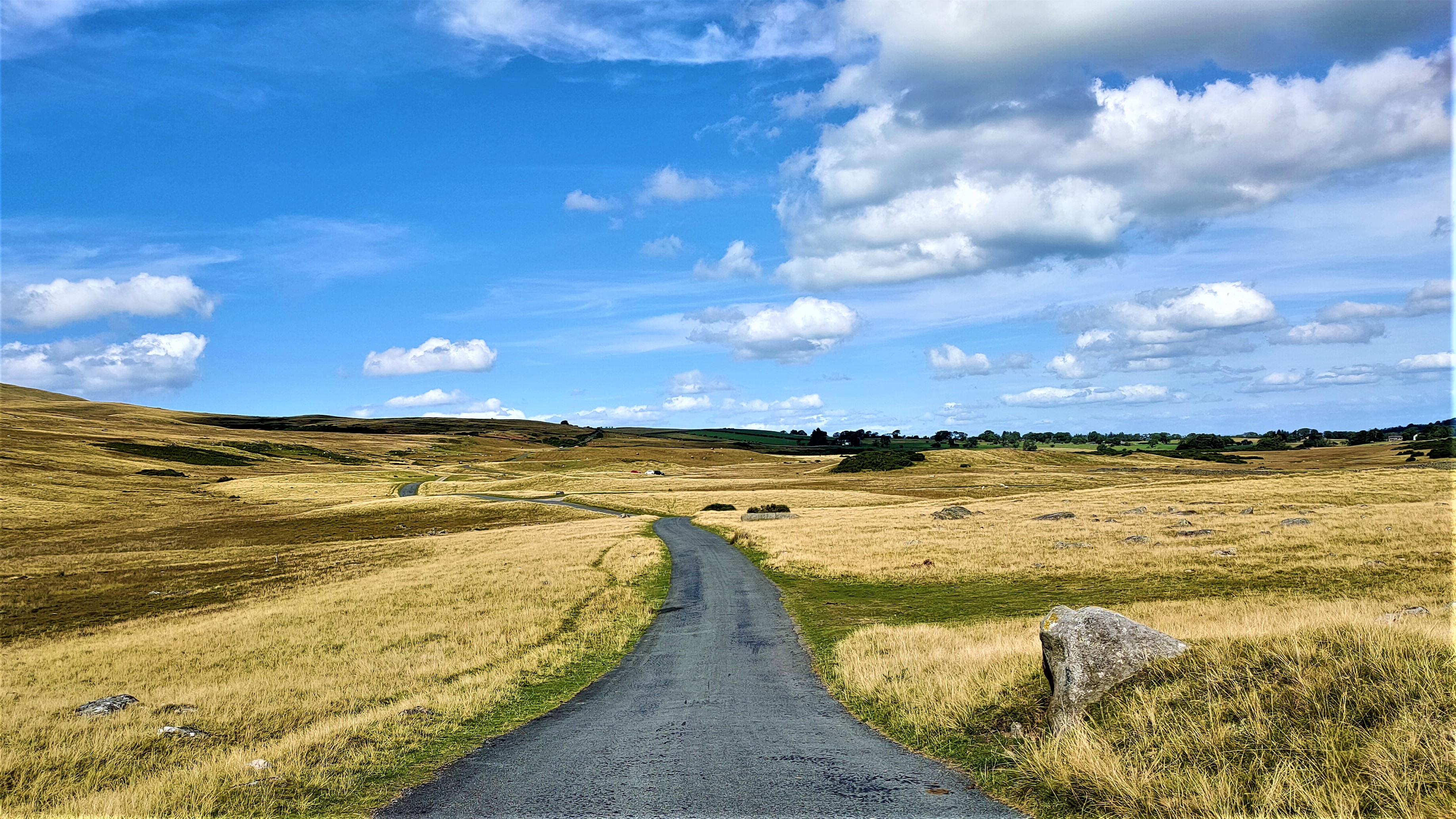
Beyond Mosedale, the road continues over open moorland. This is a view looking back after a short distance the way we’ve just come:
…and this is the road ahead, taken from the same point:
When we cycled this way last year, having reached Mosedale via Hutton Roof, we continued along the road that you see in the previous photo to Millhouse. However, on this occasion I spotted a not very obvious turn to the left, not signposted. I suspected that this road could be a bit hilly, but I asked Paula: shall we? Of course, she said ‘yes’! A short distance further on, this road comes to a ford across a
beck (another Old Norse word, meaning ‘stream’) and immediately begins to climb alarmingly. I had absolutely no hesitation: straight down to the small chainwheel. Mercifully, the steep section didn’t last long, although the road did continue to climb. The furthest point on the road in this photo marks the top of the steep section:
I took this photo of the view to the east, with the Pennines in the distance, from the same point:
And this is the road ahead:
Notice the fell ponies under the tree on the right. The road continues through the obvious gap in the trees on the horizon before beginning the long descent into Hesket Newmarket.
We did have one small problem to resolve though when we set off again. One pony had escaped the tumbledown walls of its enclosure and was stood in the middle of the road facing away from us. We wouldn’t be able to get past it in order to continue unless I could, somehow, persuade it to move over.
I don’t remember how exactly I eventually managed to succeed in this endeavour, only that I was careful not to spook the animal in case it kicked out with its hind legs. But we did finally manage to pass it.
And so began the long descent into Hesket Newmarket. We visited this village earlier this summer for the first time as part of a ride that also included Caldbeck, yet another addition to our never previously visited list. This is a view of the centre of the village:
The village pub, the Old Crown, is on the left. And this is the view from the same spot, looking in the opposite direction:
We arrived in the village via the road on the right of the photo, and we would leave via the road on the left. There is a sign here indicating a steep hill (16%), but fortunately it is downhill from here. There is a second sign, partially obscured by foliage, indicating a ‘weak bridge’ ahead.
We stopped to take some photos of the bridge, which crosses the River Caldew:
We didn’t take any more photos during this ride, but I should probably have taken one of the T-junction a short distance beyond the bridge. There was a signpost, or, more accurately, there was a post but no sign. Paula suggested following the priority road, which would have meant turning left, but I thought that continuing straight on would take us in a more favourable direction.
As it turned out, however, following my choice brought us to a series of hills, which grew increasingly taxing, to the point that I had to drop to the small chainwheel. However, we did eventually reach the long, wide and straight section of road that leads to the B5299. In retrospect, we should have turned right at the first opportunity and followed a road that leads to Castle Sowerby church (not on the map) and Lamonby (not on the signpost).
Instead, we continued to the B5299 and followed that for about three miles before turning right for Skelton. Traffic on this road isn’t heavy, but it’s fast-moving, so when we do this ride again next year, as we surely will, we will take the option via Lamonby. The road from there to Skelton is entirely downhill. Having reached Skelton on this occasion, the remaining six miles into Penrith is also easy. Yet another grand day out!
You can follow the route we took on this occasion on this map:
You may notice that the left- and right-hand sides of this map are not precisely aligned. This is because the two halves are on different pages of the Ordnance Survey road atlas that I use to plan our bike rides.


Enjoying your local tours. Places and things we saw but didn’t observe. Your references to local placenames and rapidly disappearing dialects are familiar and reassuring. I’ve biked ( we never cycled in Penrith) most of the same roads but never as purposefully as you. Keep up the good work.
ReplyDeleteThank you for the feedback John. In reply to your comment, I use the term ‘cycling’ rather than ‘biking’ because my audience includes people from many other countries. Look out for my next report, which will be the last this summer.
DeleteThank you Dennis . Biking was tongue in cheek 😊
DeleteIt WAS a day full of surprising discovery and it IS why we ENJOY so MUCH cycling in the UK!!!!!!!!!!
ReplyDeleteDiscoveries are always surprising! I’m delighted to hear you enjoyed it all.
DeleteCount me as one of the locals who prefers the name Blencathra, which means almost the same as Saddleback, but is much more poetic and romantic linking us to the oldest part of our Cumbrian heritage. Saddleback is a nice enough name but where Cumbric names like Blencathra exist, and there are many in our area, we should use them to stop losing them as they are the oldest names we have.
ReplyDeleteIt was the tourist industry in late 19th Century who attempted to change the name as they have in many places, but obviously initially it was those locals who refused to change who kept the name alive. I tend to find those who are most familiar with the mountain that are most likely to call it Blencathra.
I'm not a big fan of foxhunting but the Blencathra pack has existed for probably more than 200 years indicating that was the local name then.
In the first half of the 20th Century the tourist industry got most people to use its preferred name but now I hear more people using the Celtic name. It's good that alongside our Norse, Danish and Anglo Saxon heritage we have an even older Celtic one.
Bob
Thanks for the recent historical background Bob. I prefer the older name too, especially as there aren’t many mountains with Cumbric names now, and the language itself became extinct a thousand years ago.
Delete